Difference between revisions of "2022-03-01 47 -122"
([live picture]Stream [https://openstreetmap.org/?mlat=47.75076900&mlon=-122.28094400&zoom=16 @47.7508,-122.2809]) |
|||
| Line 1: | Line 1: | ||
| − | + | {{meetup graticule | |
| − | |||
| − | |||
| − | |||
| − | |||
| − | |||
| − | |||
| − | |||
| − | |||
| lat=47 | | lat=47 | ||
| lon=-122 | | lon=-122 | ||
| date=2022-03-01 | | date=2022-03-01 | ||
| − | }} | + | | graticule_name=Seattle |
| + | | graticule_link=Seattle, Washington | ||
| + | }} | ||
__NOTOC__ | __NOTOC__ | ||
== Location == | == Location == | ||
| − | + | Likely private property next to the Burke Gilman trail in Lake Forest Park | |
== Participants == | == Participants == | ||
| − | + | * [[User:Thomcat|Thomcat]] | |
| − | |||
== Plans == | == Plans == | ||
| Line 24: | Line 17: | ||
== Expedition == | == Expedition == | ||
| − | + | Not too far from [[2017-07-25_47_-122]], this was easy enough to check out on the way to work. | |
| + | |||
| + | I pulled into the Sheridan Beach neighborhood and drove past the fenced yard containing the geohash - house not for sale. This will be a no public access geohash. | ||
| + | |||
| + | After parking, I walked along the trail to see the view from that angle - 18 meters away - then around the block to walk in front of the house - 20 meters away. | ||
| + | |||
| + | Running through the property is McAleer creek, and quite nearby is a McAleer creek bypass, required to prevent flooding. We got more than 2" of rain this last weekend, so this bypass was running with a lot of water. Cool stuff - though I wonder what the basements of some of the older houses look (and smell) like. | ||
| + | |||
| + | Anyhow, interesting expedition, but point not reached. | ||
== Tracklog == | == Tracklog == | ||
| Line 50: | Line 51: | ||
<!-- Add any achievement ribbons you earned below, or remove this section --> | <!-- Add any achievement ribbons you earned below, or remove this section --> | ||
| − | |||
| − | |||
| − | |||
| − | |||
| − | |||
| − | |||
| − | |||
| − | |||
| − | |||
| − | |||
| − | |||
| − | |||
| − | |||
| − | |||
[[Category:Expeditions]] | [[Category:Expeditions]] | ||
| − | |||
[[Category:Expeditions with photos]] | [[Category:Expeditions with photos]] | ||
| − | |||
| − | |||
| − | |||
| − | |||
| − | |||
| − | |||
| − | |||
| − | |||
| − | |||
[[Category:Coordinates not reached]] | [[Category:Coordinates not reached]] | ||
| − | |||
| − | |||
| − | |||
| − | |||
| − | |||
[[Category:Not reached - No public access]] | [[Category:Not reached - No public access]] | ||
| − | |||
| − | |||
| − | |||
| − | |||
| − | |||
| − | |||
| − | |||
| − | |||
Revision as of 01:54, 3 March 2022
| Tue 1 Mar 2022 in Seattle: 47.7509797, -122.2811608 geohashing.info google osm bing/os kml crox |
Location
Likely private property next to the Burke Gilman trail in Lake Forest Park
Participants
Plans
Expedition
Not too far from 2017-07-25_47_-122, this was easy enough to check out on the way to work.
I pulled into the Sheridan Beach neighborhood and drove past the fenced yard containing the geohash - house not for sale. This will be a no public access geohash.
After parking, I walked along the trail to see the view from that angle - 18 meters away - then around the block to walk in front of the house - 20 meters away.
Running through the property is McAleer creek, and quite nearby is a McAleer creek bypass, required to prevent flooding. We got more than 2" of rain this last weekend, so this bypass was running with a lot of water. Cool stuff - though I wonder what the basements of some of the older houses look (and smell) like.
Anyhow, interesting expedition, but point not reached.
Tracklog
Photos
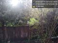
From the trail @47.7511,-122.2813
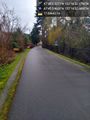
Burke Gilman eastbound @47.7511,-122.2813
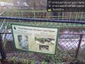
Bypass @47.7517,-122.2810
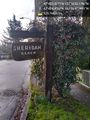
Sheridan Beach @47.7518,-122.2800
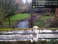
Stream @47.7508,-122.2809


