Difference between revisions of "2022-03-06 50 7"
Gefrierbrand (talk | contribs) ([live picture]sunset) |
Gefrierbrand (talk | contribs) |
||
| (5 intermediate revisions by 2 users not shown) | |||
| Line 1: | Line 1: | ||
| − | + | {{meetup graticule | |
| − | |||
| − | |||
| − | |||
| − | |||
| − | |||
| − | |||
| − | |||
| − | |||
| lat=50 | | lat=50 | ||
| lon=7 | | lon=7 | ||
| date=2022-03-06 | | date=2022-03-06 | ||
| − | }} | + | }} |
__NOTOC__ | __NOTOC__ | ||
== Location == | == Location == | ||
| − | + | Slightly off the Limestrail near Bendorf-Stromberg | |
== Participants == | == Participants == | ||
| − | + | [[User:Gefrierbrand|Gefrierbrand]] | |
| − | |||
| − | == | + | == Expedition == |
| − | + | As usual, Geohashdroid alerted me of a potentially nearby hash and other than usual, I had the time and opportunity to actually go explore it. I was traveling anyways and could adjust my route in such a way that going on a geoahasing adventure was only a very slight detour. | |
| − | + | First, I intended to go to the [https://en.wikipedia.org/wiki/Grenzau_Castle Grenzau Castle] because it popped up on the map as something interesting near to the hash. The route led through the tiny but very nice village of Grenzau, which I would have never even heard of if not for geohashing, and that's awesome. Discovering new and interesting stuff is a big part of the fun for me. I parked at the base of a hill and went along on foot climbing upwards to the castle. Unfortunately, the ruin is not open to the public at this time of year, but the view from it was still very nice and worth it. | |
| − | + | ||
| + | I had initially planned to walk towards the hash from there but a quick glance at the maps revealed no good path, so I went back to my car and used it to get to a better spot. After arriving at a nice parkingplace, I noticed quite a lot of other people walking and hiking there and wondered if they might be other hashers, but it turned out that I accidentally stumbled upon a quite frequented part of the [https://www.limesstrasse.de/deutsche-limes-strasse/trail/?L=1 Limestrail] which also happened to have a barbecuing-hut along my route where the others where flocking towards. | ||
| + | After walking for quite a while I had no trouble at all to reach the hashpoint, which was just a few meters of the Limestrail in the forest next to a somewhat larger tree. I did not feel like continuing to walk towards the other POIs in the area since it would have meant having to travel the same distance back again, I returned back home directly leaving the roman watchtower and an old railway-bridge for another time. | ||
| − | |||
| − | |||
== Tracklog == | == Tracklog == | ||
| − | + | {{tracklog | T2022-03-06-18-01 gh limes.gpx}} | |
== Photos == | == Photos == | ||
| − | |||
| − | |||
| − | |||
<gallery perrow="5"> | <gallery perrow="5"> | ||
| − | + | Image:2022-03-06_50_7_Gefrierbrand_1646594320773.jpg|view on Grenzau | |
| − | Image:2022-03-06_50_7_Gefrierbrand_1646594215619.jpg| | + | Image:2022-03-06_50_7_Gefrierbrand_1646594303018.jpg|Grenzau Castle |
| − | + | Image:2022-03-06_50_7_Gefrierbrand_1646594282892.jpg|sunset in the forest | |
| + | Image:2022-03-06_50_7_Gefrierbrand_1646594215619.jpg|StupidGrin<sup>TM</sup> | ||
Image:2022-03-06_50_7_Gefrierbrand_1646594257807.jpg|proof | Image:2022-03-06_50_7_Gefrierbrand_1646594257807.jpg|proof | ||
| − | |||
| − | |||
</gallery> | </gallery> | ||
== Achievements == | == Achievements == | ||
{{#vardefine:ribbonwidth|800px}} | {{#vardefine:ribbonwidth|800px}} | ||
| − | + | {{land geohash | |
| − | + | | latitude =50 | |
| − | + | | longitude = 7 | |
| − | + | | date = 2022-03-06 | |
| − | + | | name = Gefrierbrand | |
| − | + | }} | |
| − | + | {{Ribbon | |
| − | + | |icon = Border.PNG | |
| − | + | |color = darkblue | |
| − | + | |user = Gefrierbrand | |
| − | [[ | + | |achievement = historical Border geohash achievement |
| − | -- | + | |action = crossing the ancient roman empires border on [[2022-03-06 50 7|2022-03-06]] |
| − | + | |category = Border geohash achievement | |
| − | + | }} | |
| − | |||
| − | |||
[[Category:Expeditions]] | [[Category:Expeditions]] | ||
| − | |||
[[Category:Expeditions with photos]] | [[Category:Expeditions with photos]] | ||
| − | |||
| − | |||
| − | |||
| − | |||
| − | |||
[[Category:Coordinates reached]] | [[Category:Coordinates reached]] | ||
| − | + | {{location|DE|RP|MYK}} | |
| − | |||
| − | |||
| − | |||
| − | |||
| − | |||
| − | |||
| − | |||
| − | |||
| − | |||
| − | |||
| − | |||
| − | |||
| − | |||
| − | |||
| − | |||
| − | |||
| − | |||
Latest revision as of 15:43, 7 March 2022
| Sun 6 Mar 2022 in 50,7: 50.4424864, 7.6064815 geohashing.info google osm bing/os kml crox |
Location
Slightly off the Limestrail near Bendorf-Stromberg
Participants
Expedition
As usual, Geohashdroid alerted me of a potentially nearby hash and other than usual, I had the time and opportunity to actually go explore it. I was traveling anyways and could adjust my route in such a way that going on a geoahasing adventure was only a very slight detour.
First, I intended to go to the Grenzau Castle because it popped up on the map as something interesting near to the hash. The route led through the tiny but very nice village of Grenzau, which I would have never even heard of if not for geohashing, and that's awesome. Discovering new and interesting stuff is a big part of the fun for me. I parked at the base of a hill and went along on foot climbing upwards to the castle. Unfortunately, the ruin is not open to the public at this time of year, but the view from it was still very nice and worth it.
I had initially planned to walk towards the hash from there but a quick glance at the maps revealed no good path, so I went back to my car and used it to get to a better spot. After arriving at a nice parkingplace, I noticed quite a lot of other people walking and hiking there and wondered if they might be other hashers, but it turned out that I accidentally stumbled upon a quite frequented part of the Limestrail which also happened to have a barbecuing-hut along my route where the others where flocking towards.
After walking for quite a while I had no trouble at all to reach the hashpoint, which was just a few meters of the Limestrail in the forest next to a somewhat larger tree. I did not feel like continuing to walk towards the other POIs in the area since it would have meant having to travel the same distance back again, I returned back home directly leaving the roman watchtower and an old railway-bridge for another time.
Tracklog
Photos
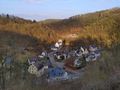
view on Grenzau
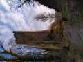
Grenzau Castle
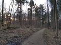
sunset in the forest

StupidGrinTM
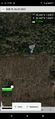
proof


Achievements
Gefrierbrand earned the Land geohash achievement
|
Gefrierbrand earned the historical Border geohash achievement
|