Difference between revisions of "2022-03-11 50 8"
From Geohashing
(→Tracklog) |
|||
| Line 52: | Line 52: | ||
<!-- Add any achievement ribbons you earned below, or remove this section --> | <!-- Add any achievement ribbons you earned below, or remove this section --> | ||
| − | |||
| − | |||
| − | |||
| − | |||
| − | |||
| − | |||
| − | |||
| − | |||
| − | |||
| − | |||
| − | |||
| − | |||
| − | |||
| − | |||
[[Category:Expeditions]] | [[Category:Expeditions]] | ||
| − | |||
[[Category:Expeditions with photos]] | [[Category:Expeditions with photos]] | ||
| − | |||
| − | |||
| − | |||
| − | |||
| − | |||
[[Category:Coordinates reached]] | [[Category:Coordinates reached]] | ||
| − | |||
| − | |||
| − | |||
| − | |||
| − | |||
| − | |||
| − | |||
| − | |||
| − | |||
| − | |||
| − | |||
| − | |||
| − | |||
| − | |||
| − | |||
| − | |||
| − | |||
| − | |||
Revision as of 19:16, 18 March 2022
| Fri 11 Mar 2022 in 50,8: 50.2343601, 8.6326822 geohashing.info google osm bing/os kml crox |
Location
In the Hardtwald forest right next to Bad Homburg. 20 meters off the trail.
Participants
Plans
Walk from Seulberg to the hash point and continue to Bad Homburg.
Expedition
This is my first attempt at reaching a hash point. I don't have a car, so the location needs to be reachable via public transport and hiking. This one seemed pretty easy.
I walked here on foot from Seulberg on this sunny Friday in early spring. Lots of people passing by. I arrived at the hash point at 14:15. It was a beautiful sunny spot. I sat down on a tree trunk that was placed directly at the coordinates. It was warm and comfortable here, so I stayed for some time to chill and read a book. At 15:00 I continued on my walk to Bad Homburg main station.
Tracklog
Photos
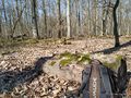
hash location
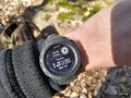
proof
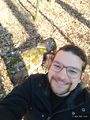
the face picture


