Difference between revisions of "2022-03-16 53 6"
(Created page with "{{subst:expedition}}") |
|||
| Line 1: | Line 1: | ||
| − | + | {{meetup graticule | |
| − | |||
| − | |||
| − | |||
| − | |||
| − | |||
| − | |||
| − | |||
| − | |||
| lat={{#explode:{{SUBPAGENAME}}| |1}} | | lat={{#explode:{{SUBPAGENAME}}| |1}} | ||
| lon={{#explode:{{SUBPAGENAME}}| |2}} | | lon={{#explode:{{SUBPAGENAME}}| |2}} | ||
| date={{#explode:{{SUBPAGENAME}}| |0}} | | date={{#explode:{{SUBPAGENAME}}| |0}} | ||
| − | }} | + | }} |
__NOTOC__ | __NOTOC__ | ||
== Location == | == Location == | ||
| − | + | The hash is very close to my home. It seems to be in a park which is easily accessible, but for some reason I currently can't remember exactly what it looks like there. But it's close enough to walk, so I'll just go there and see. | |
== Participants == | == Participants == | ||
| − | + | [[User:Shevek|Shevek]] ([[User talk:Shevek|talk]]) | |
| − | |||
== Plans == | == Plans == | ||
| − | + | I considered getting the juggernaut achievement. It's rare that that would be reasonably doable and this seemed to be that case. I'd just need to jump into or swim through a few small canals. However, after reading the conditions I found that I would be disqualified because the hash was too close. So that will have to wait for some other time. The new plan is to just go there and check it out. | |
== Expedition == | == Expedition == | ||
| − | + | The hash is close to a canal. I often go for a walk on the other side of that, so I went there first. Then I realized why the location didn't ring a bell for me before: it's on the terrain of a sports club, with a fence around it. I probably wasn't allowed to go there! | |
| − | + | But I didn't give up so easily. I want around it to the entrance, to see if perhaps it was open. While doing that, it was already obvious that nobody was playing on the field at that time, so it was unlikely. But checking doesn't hurt. | |
| − | + | ||
| + | When I arrived at the gate, I found it open. But after going through it, I immediately encountered a sign saying I wasn't allowed to enter. That made me stop, because I don't like breaking the law. So I was about to turn back and report a failed expedition, but then I saw that there was a car parked a bit further. I thought maybe there was someone there who I could ask for permission to go to the hash. Because the hash was not even on the field, I'm sure it would have been fine. So I went onto the terrain towards the parked car. | ||
| + | |||
| + | But when I got there, there was nobody around. They were probably in the building. I didn't feel like bothering them, so I decided to leave. But then I saw that I was already almost at the hash. So I couldn't help myself and I went there anyway. I took a few pictures and left. | ||
== Photos == | == Photos == | ||
| − | |||
| − | |||
| − | |||
<gallery perrow="5"> | <gallery perrow="5"> | ||
| + | Image:2022-03-16_53_6_fence.jpg | The fence was open | ||
| + | Image:2022-03-16_53_6_forbidden.jpg | and though I wasn't allowed to enter... | ||
| + | Image:2022-03-16_53_6_reached.jpg | I did anyway | ||
| + | Image:2022-03-16_53_6_proof.png | and I reached the hash! | ||
</gallery> | </gallery> | ||
== Achievements == | == Achievements == | ||
{{#vardefine:ribbonwidth|800px}} | {{#vardefine:ribbonwidth|800px}} | ||
| − | + | {{land geohash | latitude = 53 | longitude = 6 | date = 2022-03-16 | name = Shevek | image = 2022-03-16_53_6_reached.jpg }} | |
| + | {{bicycle geohash | latitude = 53 | longitude = 6 | date = 2022-03-16 | name = Shevek | distance = 500 m | bothways = true | image = 2022-03-16_53_6_fence.jpg }} | ||
| − | |||
| − | |||
| − | |||
| − | |||
| − | |||
| − | |||
| − | |||
| − | |||
| − | |||
| − | |||
| − | |||
| − | |||
| − | |||
| − | |||
[[Category:Expeditions]] | [[Category:Expeditions]] | ||
| − | |||
[[Category:Expeditions with photos]] | [[Category:Expeditions with photos]] | ||
| − | |||
| − | |||
| − | |||
| − | |||
| − | |||
[[Category:Coordinates reached]] | [[Category:Coordinates reached]] | ||
| − | + | [[Category:Shevek]] | |
| − | + | {{location|NL|GR}} | |
| − | |||
| − | |||
| − | |||
| − | |||
| − | |||
| − | |||
| − | |||
| − | |||
| − | |||
| − | |||
| − | [[Category: | ||
| − | |||
| − | |||
| − | |||
| − | |||
| − | |||
Latest revision as of 20:46, 30 March 2022
| Wed 16 Mar 2022 in 53,6: 53.2428920, 6.6079597 geohashing.info google osm bing/os kml crox |
Location
The hash is very close to my home. It seems to be in a park which is easily accessible, but for some reason I currently can't remember exactly what it looks like there. But it's close enough to walk, so I'll just go there and see.
Participants
Plans
I considered getting the juggernaut achievement. It's rare that that would be reasonably doable and this seemed to be that case. I'd just need to jump into or swim through a few small canals. However, after reading the conditions I found that I would be disqualified because the hash was too close. So that will have to wait for some other time. The new plan is to just go there and check it out.
Expedition
The hash is close to a canal. I often go for a walk on the other side of that, so I went there first. Then I realized why the location didn't ring a bell for me before: it's on the terrain of a sports club, with a fence around it. I probably wasn't allowed to go there!
But I didn't give up so easily. I want around it to the entrance, to see if perhaps it was open. While doing that, it was already obvious that nobody was playing on the field at that time, so it was unlikely. But checking doesn't hurt.
When I arrived at the gate, I found it open. But after going through it, I immediately encountered a sign saying I wasn't allowed to enter. That made me stop, because I don't like breaking the law. So I was about to turn back and report a failed expedition, but then I saw that there was a car parked a bit further. I thought maybe there was someone there who I could ask for permission to go to the hash. Because the hash was not even on the field, I'm sure it would have been fine. So I went onto the terrain towards the parked car.
But when I got there, there was nobody around. They were probably in the building. I didn't feel like bothering them, so I decided to leave. But then I saw that I was already almost at the hash. So I couldn't help myself and I went there anyway. I took a few pictures and left.
Photos
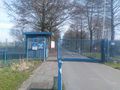
The fence was open
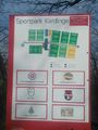
and though I wasn't allowed to enter...

I did anyway
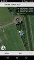
and I reached the hash!


Achievements
Shevek earned the Land geohash achievement
|
Shevek earned the Bicycle geohash achievement
|