Difference between revisions of "2022-03-23 48 11"
Clearlucid9 (talk | contribs) (→Photos) |
|||
| Line 12: | Line 12: | ||
| date=2022-03-23 | | date=2022-03-23 | ||
}}<!-- edit as necessary --> | }}<!-- edit as necessary --> | ||
| − | |||
== Location == | == Location == | ||
<!-- where you've surveyed the hash to be --> | <!-- where you've surveyed the hash to be --> | ||
| Line 21: | Line 20: | ||
--> | --> | ||
[[User:Clearlucid9|Clearlucid9]] ([[User talk:Clearlucid9|talk]]) | [[User:Clearlucid9|Clearlucid9]] ([[User talk:Clearlucid9|talk]]) | ||
| − | |||
| − | |||
| − | |||
== Expedition == | == Expedition == | ||
| Line 29: | Line 25: | ||
I decided to try reaching this hash going on my bicicle. It took me about 45 minutes to get there and then I had to find my way through the underwood to reach the coodrdinates. On my way back I took a break in the Kugler Alm - a well known beergarden where they suposedly invented the shandy ("Radler" in German, which in Bavaria also means "cyclist"): on a hot day when they had so many cyclist coming there from Munich city and they were afraid to run out of beer and stared to mix it with lemonade... | I decided to try reaching this hash going on my bicicle. It took me about 45 minutes to get there and then I had to find my way through the underwood to reach the coodrdinates. On my way back I took a break in the Kugler Alm - a well known beergarden where they suposedly invented the shandy ("Radler" in German, which in Bavaria also means "cyclist"): on a hot day when they had so many cyclist coming there from Munich city and they were afraid to run out of beer and stared to mix it with lemonade... | ||
After consuming half a grilled chicken with potato salad and a Radlerhalbe (1/2 litre of shandy), I cycled back home, ariving tired, but well fed. | After consuming half a grilled chicken with potato salad and a Radlerhalbe (1/2 litre of shandy), I cycled back home, ariving tired, but well fed. | ||
| − | |||
| − | |||
| − | |||
== Photos == | == Photos == | ||
| Line 49: | Line 42: | ||
<!-- Add any achievement ribbons you earned below, or remove this section --> | <!-- Add any achievement ribbons you earned below, or remove this section --> | ||
| − | + | __NOTOC__ | |
| − | |||
| − | |||
| − | |||
| − | |||
| − | |||
| − | |||
| − | |||
| − | |||
| − | |||
| − | |||
| − | |||
| − | |||
| − | |||
[[Category:Expeditions]] | [[Category:Expeditions]] | ||
| − | |||
[[Category:Expeditions with photos]] | [[Category:Expeditions with photos]] | ||
| − | |||
| − | |||
| − | |||
| − | |||
| − | |||
[[Category:Coordinates reached]] | [[Category:Coordinates reached]] | ||
| − | |||
| − | |||
| − | |||
| − | |||
| − | |||
| − | |||
| − | |||
| − | |||
| − | |||
| − | |||
| − | |||
| − | |||
| − | |||
| − | |||
| − | |||
| − | |||
| − | |||
| − | |||
Revision as of 10:46, 8 April 2022
| Wed 23 Mar 2022 in 48,11: 48.0358862, 11.5663449 geohashing.info google osm bing/os kml crox |
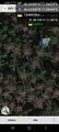
Location
in the Forrest behind a well known Biergarden in Oberhaching
Participants
Expedition
I decided to try reaching this hash going on my bicicle. It took me about 45 minutes to get there and then I had to find my way through the underwood to reach the coodrdinates. On my way back I took a break in the Kugler Alm - a well known beergarden where they suposedly invented the shandy ("Radler" in German, which in Bavaria also means "cyclist"): on a hot day when they had so many cyclist coming there from Munich city and they were afraid to run out of beer and stared to mix it with lemonade... After consuming half a grilled chicken with potato salad and a Radlerhalbe (1/2 litre of shandy), I cycled back home, ariving tired, but well fed.
Photos
Logproof @48.0359,11.5664
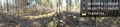
Panoramic view from the hash coordinates @48.0358,11.5665