Difference between revisions of "2022-03-23 48 11"
Clearlucid9 (talk | contribs) (An expedition message sent via Geohash Droid for Android.) |
m |
||
| (13 intermediate revisions by 3 users not shown) | |||
| Line 12: | Line 12: | ||
| date=2022-03-23 | | date=2022-03-23 | ||
}}<!-- edit as necessary --> | }}<!-- edit as necessary --> | ||
| − | |||
== Location == | == Location == | ||
<!-- where you've surveyed the hash to be --> | <!-- where you've surveyed the hash to be --> | ||
| + | in the Forrest behind a well known Beergarden in Oberhaching | ||
== Participants == | == Participants == | ||
<!-- who attended: If you link to your wiki user name in this section, your expedition will be picked up by the various statistics generated for geohashing. You may use three tildes ~ as a shortcut to automatically insert the user signature of the account you are editing with. | <!-- who attended: If you link to your wiki user name in this section, your expedition will be picked up by the various statistics generated for geohashing. You may use three tildes ~ as a shortcut to automatically insert the user signature of the account you are editing with. | ||
--> | --> | ||
| − | + | [[User:Clearlucid9|Clearlucid9]] ([[User talk:Clearlucid9|talk]]) | |
| − | |||
| − | |||
== Expedition == | == Expedition == | ||
<!-- how it all turned out. your narrative goes here. --> | <!-- how it all turned out. your narrative goes here. --> | ||
| − | + | I decided to try reaching this hash going on my bicicle. It took me about 45 minutes to get there and then I had to find my way through the underwood to reach the coodrdinates. On my way back I took a break in the Kugler Alm - a well known beergarden where they suposedly invented the shandy ("Radler" in German, which in Bavaria also means "cyclist"): on a hot day when they had so many cyclist coming there from Munich city and they were afraid to run out of beer and stared to mix it with lemonade... | |
| − | + | After consuming half a grilled chicken with potato salad and a Radlerhalbe (1/2 litre of shandy), I cycled back home, ariving tired, but well fed. | |
| − | |||
== Photos == | == Photos == | ||
| Line 34: | Line 31: | ||
--> | --> | ||
<gallery perrow="5"> | <gallery perrow="5"> | ||
| + | |||
| + | Image:2022-03-23_48_11_Clearlucid9 _1648039928509.jpg|Logproof [https://openstreetmap.org/?mlat=48.03586280&mlon=11.56644420&zoom=16 @48.0359,11.5664] | ||
| + | |||
| + | Image:2022-03-23_48_11_Clearlucid9 _1648039982158.jpg|Panoramic view from the hash coordinates [https://openstreetmap.org/?mlat=48.03577320&mlon=11.56654830&zoom=16 @48.0358,11.5665] | ||
| + | |||
| + | Image:2022-03-23 14.24.47.jpg|in the Biergarten | ||
</gallery> | </gallery> | ||
| Line 40: | Line 43: | ||
<!-- Add any achievement ribbons you earned below, or remove this section --> | <!-- Add any achievement ribbons you earned below, or remove this section --> | ||
| − | + | __NOTOC__ | |
| − | |||
| − | |||
| − | |||
| − | |||
| − | |||
| − | |||
| − | |||
| − | |||
| − | |||
| − | |||
| − | |||
| − | |||
| − | |||
[[Category:Expeditions]] | [[Category:Expeditions]] | ||
| − | |||
[[Category:Expeditions with photos]] | [[Category:Expeditions with photos]] | ||
| − | |||
| − | |||
| − | |||
| − | |||
| − | |||
[[Category:Coordinates reached]] | [[Category:Coordinates reached]] | ||
| − | + | {{location|DE|BY|M}} | |
| − | |||
| − | |||
| − | |||
| − | |||
| − | |||
| − | |||
| − | |||
| − | |||
| − | |||
| − | |||
| − | |||
| − | |||
| − | |||
| − | |||
| − | |||
| − | |||
| − | |||
Latest revision as of 10:24, 9 April 2022
| Wed 23 Mar 2022 in 48,11: 48.0358862, 11.5663449 geohashing.info google osm bing/os kml crox |
Location
in the Forrest behind a well known Beergarden in Oberhaching
Participants
Expedition
I decided to try reaching this hash going on my bicicle. It took me about 45 minutes to get there and then I had to find my way through the underwood to reach the coodrdinates. On my way back I took a break in the Kugler Alm - a well known beergarden where they suposedly invented the shandy ("Radler" in German, which in Bavaria also means "cyclist"): on a hot day when they had so many cyclist coming there from Munich city and they were afraid to run out of beer and stared to mix it with lemonade... After consuming half a grilled chicken with potato salad and a Radlerhalbe (1/2 litre of shandy), I cycled back home, ariving tired, but well fed.
Photos
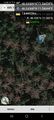
Logproof @48.0359,11.5664
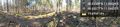
Panoramic view from the hash coordinates @48.0358,11.5665
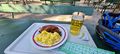
in the Biergarten
