Difference between revisions of "2022-03-28 49 8"
([live picture]Hash success at Lake Forrestduck...) |
m |
||
| (5 intermediate revisions by 3 users not shown) | |||
| Line 14: | Line 14: | ||
__NOTOC__ | __NOTOC__ | ||
== Location == | == Location == | ||
| − | + | The hash was located right next to a small pond near the Böllenfalltor in Darmstadt. | |
== Participants == | == Participants == | ||
| − | + | *[[User:Santu|Santu]] | |
| − | + | *Pedro the dog | |
| + | *[[User:Rincewind|Rincewind]] | ||
== Plans == | == Plans == | ||
| − | + | The hash seemed to be a rather easy one so I didn't bother to do much of planning. But apparently I should have at least announced my non-plans so a meeting with Rincewind would have easily been possible. Apologies for messing this up! | |
== Expedition == | == Expedition == | ||
| − | + | I just grabbed Pedro and we got onto the bus to the Böllenfalltor from where we walked towards the police HQ. As there was no trace of a path in GMaps I decided to circle the area clockwise and eventually found a nice little path that led directly to the hash. | |
| + | |||
| + | Only my reluctance to crawl through the bushes prevented me from making a fool of myself by forcing my way to the hash from south! Gladly the botanical close-up could be avoided and I detected an interesting giang oak with some part of the bark looking like a secret door. | ||
| − | |||
| − | |||
== Photos == | == Photos == | ||
| Line 33: | Line 34: | ||
Image:2020-##-## ## ## Alpha.jpg | Witty Comment | Image:2020-##-## ## ## Alpha.jpg | Witty Comment | ||
--> | --> | ||
| + | Rincewind: | ||
<gallery perrow="5"> | <gallery perrow="5"> | ||
| + | Image:2022-03-28_49_8_Rincewind_1648489870903.jpg|Hash success at Lake Forrestduck... | ||
| − | + | ||
| + | </gallery> | ||
| + | Santu: | ||
| + | <gallery perrow="5"> | ||
| + | File:2022-03-28 49-8 Oak.JPG|Giant oak with secret door | ||
| + | File:2022-03-28 49-8 Proof.jpg|Proof for Santu and Pedro | ||
| + | File:2022-03-28 49-8 Grin.JPG|StupidGrin<sup>TM</sup> by Santu and Pedro | ||
</gallery> | </gallery> | ||
| Line 42: | Line 51: | ||
<!-- Add any achievement ribbons you earned below, or remove this section --> | <!-- Add any achievement ribbons you earned below, or remove this section --> | ||
| − | |||
| − | |||
| − | |||
| − | + | [[Category:Expeditions]] | |
| − | + | [[Category:Expeditions with photos]] | |
| − | |||
| − | [[Category: | ||
| − | |||
| − | |||
| − | |||
| − | |||
| − | |||
| − | |||
| − | |||
| − | |||
| − | |||
| − | |||
| − | |||
| − | |||
[[Category:Coordinates reached]] | [[Category:Coordinates reached]] | ||
| − | + | {{location|DE|HE|DA|city=true}} | |
| − | |||
| − | |||
| − | |||
| − | |||
| − | |||
| − | |||
| − | |||
| − | |||
| − | |||
| − | |||
| − | |||
| − | |||
| − | |||
| − | |||
| − | |||
| − | |||
| − | |||
Latest revision as of 22:10, 28 March 2022
| Mon 28 Mar 2022 in 49,8: 49.8519055, 8.6640472 geohashing.info google osm bing/os kml crox |
Location
The hash was located right next to a small pond near the Böllenfalltor in Darmstadt.
Participants
Plans
The hash seemed to be a rather easy one so I didn't bother to do much of planning. But apparently I should have at least announced my non-plans so a meeting with Rincewind would have easily been possible. Apologies for messing this up!
Expedition
I just grabbed Pedro and we got onto the bus to the Böllenfalltor from where we walked towards the police HQ. As there was no trace of a path in GMaps I decided to circle the area clockwise and eventually found a nice little path that led directly to the hash.
Only my reluctance to crawl through the bushes prevented me from making a fool of myself by forcing my way to the hash from south! Gladly the botanical close-up could be avoided and I detected an interesting giang oak with some part of the bark looking like a secret door.
Photos
Rincewind:
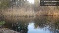
Hash success at Lake Forrestduck...

Santu:
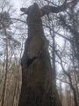
Giant oak with secret door
Proof for Santu and Pedro

StupidGrinTM by Santu and Pedro


