Difference between revisions of "2022-04-06 -37 145"
([live] Success LLC) |
|||
| Line 1: | Line 1: | ||
| − | + | [[File:PXL_20220406_073324263.jpg|400px|thumb|left]] | |
| − | |||
| − | + | {{meetup graticule | |
| − | |||
| − | |||
| − | |||
| − | |||
| lat=-37 | | lat=-37 | ||
| lon=145 | | lon=145 | ||
| Line 17: | Line 12: | ||
== Participants == | == Participants == | ||
| − | + | *[[User:Stevage|Stevage]] | |
| − | |||
| − | |||
== Plans == | == Plans == | ||
<!-- what were the original plans --> | <!-- what were the original plans --> | ||
== Expedition == | == Expedition == | ||
| − | + | What is it about geohashing that turns the simplest, most straightforward plans into complicated off-track bushbashing adventures slogging up precarious slopes with bike balanced improbably over one shoulder? | |
| + | |||
| + | Let's back up. After a series of disappointly faraway points in locations of questionable accessibility, today's geohash lands squarely in a patch of apparently accessible bushland, on a regular old suburban road, not far from the outer train station of Hurstbridge. The home of many mountain bike adventures, owing to its base at the foothills of the Christmas Hills, and on the way up to Kinglake. | ||
| + | |||
| + | Due to a self-inflicted waste of an afternoon, I didn't have all that much time to get there and back before a planned evening of swim, spa, sauna and steam room. So, the hero of this adventure plans to take the train like a good little boy, ride a short distance along a sealed road, quickly scramble up a small slope, and do all the above in reverse. Easy. Simple. Hard to see how this could go wrong, really. | ||
| + | |||
| + | It starts well. The first train at Westgarth arrives just as we do. We touch on. We board. We octupus-strap our bike securely to a railing. We begin listening to a podcast, "Dolly Parton's America". I'm not sure I really want to know more about Dolly Parton, or about America, but Jad Abumrad is an amazing radio producer, and on that basis, we give it a go. | ||
| + | |||
| + | At Eltham Station, however, the train unexpectedly terminates, leaving us with a decision: wait 20 minutes for the next, or just ride a bit further, along the Diamond Creek Trail? You may have guessed which way we decide. | ||
| + | |||
| + | Although I have done this section of trail a few times before, somehow I'm always surprised by how crappy the experience is. It weaves randomly back and forth across the track, across roads, across the creek. It feels more like a random assortment of footpaths glued together by a bureaucrat than a real coherent trail. Even following the map on my phone, it's a tedious and unflowful experience. | ||
| + | |||
| + | And then we reach a fence across the trail, imploring us not to continue, but to instead follow a detour via -- well, had I bothered to read the sign, I'd be able to tell you -- but we do indeed continue, following a well worn grove through the grass. We enter semi-forbidden territory. | ||
| + | |||
| + | Soon, I notice to our right a gaping hole where apparently a bridge ought to be. It's an impressive absence. A sort of stark missingness, the only presentness being pieces of bridge normally not noticed - stumps and footings and anchors and such. But as far as a decking to ride over, or any such luxuries, no such luckery. We continue along the same side of the creek, trusting that it will all work out somehow. It does not. | ||
| + | |||
| + | Our path leads soon to streets. Consulting the map leads to an unwelcome conclusion that these streets will not take us where we want to go, but only back where we have come from, which is incorrect. There is yet another boring sign full of tiresome details about some kind of detour that frankly we just don't have the patience to read. We need to ''go somewhere'', not stand around ''reading things''. | ||
| + | |||
| + | Alternatively, we can continue off the sealed path onto that extremely rough dirt goat's track that follows the creek, which surely will take us exactly where we want to go, right? It's a fun little ride at first. The vegetation is open, the riding is easy. Until it isn't. The bush closes around us, the scrub as prickly as Dolly and Porter Waggoner's relationship, and the dirt track becomes increasingly bumpy. In our heart, we know this isn't going to work out, but it's easy enough to ignore that voice because turning around wouldn't be fun, and we're doing this for fun. | ||
| + | |||
| + | But now the hill to our left has become a towering cliff above us, and to our right there is a sheep drop down to the creek. The gap between these two things narrows and narrows until there is really nothing between them other than a very sketchy slopey little slippery sandy embankment that we can tiptoe across maybe but not while carrying a bike, and in any case where would be trying to get to because this clearly isn't going to get any better. | ||
| + | |||
| + | With some kind of melodramatic sigh, we accept our fate and return towards the missing bridge, tearing up slightly as we hear the strains of "I will always love you" and its original context of Dolly exiting what had become a toxic business partnership and relationshp of uncertain nature. | ||
| + | |||
| + | We notice something that had slipped our grasp before: there is in fact a narrow plank down at creek level in the midst of the non-existent bridge. It is easy to get down to and across. But here we find ourselves beneath a steep, very slippery bank with the bike on the shoulder, as in so many previous geohashing expeditions. We wonder where we went wrong. Was it the choice of footwear? Would tying the laces tighter have made a big difference? Perhaps just a lighter load? Was there a better way up this slope? Whatever the case, eventually we emerge at the top, fractionally triumphant, moderately irritated, but our resolve undaunted. Onwards. | ||
| + | |||
| + | The trail improves dramatically, and now we are flowing northward, outward, enjoying trees and birds and dogs and snatches of strangers' overheard conversations and the mysterious phenomenon known as Dollywood. | ||
| + | |||
| + | Effortless we glide into Hurstbridge and then out of it, connecting with the road network at curious point, where the road narrows so much for a bridge that traffic alternately backs up in each direction. We watch the phenomenon for a few iterations, working out the pattern, then leap into the fray like a frog leaping onto fast-floating lilypad, and we skilfully avoid a flattening. | ||
| + | Then almost at once we are at the place. The embankment is so much higher and steeper than we imagined, and to be perfectly honest, we've done enough steep embankment scrambling for one day, so we back up a bit and find a way to creep our way up onto it across the grass. It's not at all clear what this piece of land is. Is it private property? There's a rusty barbed wire fence but no sign of any houses, just a few mounds of dung from some possibly unfamiliar animal. | ||
| + | |||
| + | Mindful of being extremely visible (high vis clothing sometimes has that effect) to neighbours in all directions, not to mention the busy evening traffic, we decide to make our dash as quick as possible. A quick commando roll under the barbed wire fence (helpfully some previous person had forced open a hole and left it propped open) and scurry quickly to the point. Our app flashes green, we take a couple of quick photos, we make a run for it. Our battery is low but our spirits are high. | ||
| + | |||
| + | In Hurstbridge, we round out the adventure with a series of terrible (but un-storyworthy) decisions involving takeaway noodles and eventually get a train home. There is a Herald-Sun to read, which seems fitting. Alas, our misadventures (actually, mostly the takeaway noodle bit) preclude the proposed pool party which will have to wait for another time. | ||
| − | |||
| − | |||
| − | |||
== Photos == | == Photos == | ||
| − | |||
| − | |||
| − | |||
<gallery perrow="5"> | <gallery perrow="5"> | ||
| + | File:PXL_20220406_063404791.jpg|A mysterious hobbit hole. | ||
| + | File:PXL_20220406_062145354.jpg|The path is getting sketchier... | ||
| + | File:PXL_20220406_061904402.jpg|...and sketchier | ||
| + | File:PXL_20220406_062316753.jpg|The creekside path becomes too non-existent to continue. | ||
| + | File:PXL_20220406_072809608.jpg|The final embankment as seen from the roadway. | ||
| + | File:PXL_20220406_063910762.jpg|The case of the missing bridge. | ||
| + | File:PXL_20220406_073333129.jpg|The hash! | ||
| + | File:PXL_20220406_073324263.jpg|With me in it! | ||
</gallery> | </gallery> | ||
| Line 42: | Line 70: | ||
<!-- Add any achievement ribbons you earned below, or remove this section --> | <!-- Add any achievement ribbons you earned below, or remove this section --> | ||
| − | |||
| − | |||
| − | |||
| − | |||
| − | |||
| − | |||
| − | |||
| − | |||
| − | |||
| − | |||
| − | |||
| − | |||
| − | |||
| − | |||
[[Category:Expeditions]] | [[Category:Expeditions]] | ||
| − | |||
[[Category:Expeditions with photos]] | [[Category:Expeditions with photos]] | ||
| − | |||
| − | |||
| − | |||
| − | |||
| − | |||
[[Category:Coordinates reached]] | [[Category:Coordinates reached]] | ||
| − | |||
| − | |||
| − | |||
| − | |||
| − | |||
| − | |||
| − | |||
| − | |||
| − | |||
| − | |||
| − | |||
| − | |||
| − | |||
| − | |||
| − | |||
| − | |||
| − | |||
| − | |||
Revision as of 10:12, 6 April 2022

| Wed 6 Apr 2022 in -37,145: -37.6329324, 145.1853723 geohashing.info google osm bing/os kml crox |
Location
Participants
Plans
Expedition
What is it about geohashing that turns the simplest, most straightforward plans into complicated off-track bushbashing adventures slogging up precarious slopes with bike balanced improbably over one shoulder?
Let's back up. After a series of disappointly faraway points in locations of questionable accessibility, today's geohash lands squarely in a patch of apparently accessible bushland, on a regular old suburban road, not far from the outer train station of Hurstbridge. The home of many mountain bike adventures, owing to its base at the foothills of the Christmas Hills, and on the way up to Kinglake.
Due to a self-inflicted waste of an afternoon, I didn't have all that much time to get there and back before a planned evening of swim, spa, sauna and steam room. So, the hero of this adventure plans to take the train like a good little boy, ride a short distance along a sealed road, quickly scramble up a small slope, and do all the above in reverse. Easy. Simple. Hard to see how this could go wrong, really.
It starts well. The first train at Westgarth arrives just as we do. We touch on. We board. We octupus-strap our bike securely to a railing. We begin listening to a podcast, "Dolly Parton's America". I'm not sure I really want to know more about Dolly Parton, or about America, but Jad Abumrad is an amazing radio producer, and on that basis, we give it a go.
At Eltham Station, however, the train unexpectedly terminates, leaving us with a decision: wait 20 minutes for the next, or just ride a bit further, along the Diamond Creek Trail? You may have guessed which way we decide.
Although I have done this section of trail a few times before, somehow I'm always surprised by how crappy the experience is. It weaves randomly back and forth across the track, across roads, across the creek. It feels more like a random assortment of footpaths glued together by a bureaucrat than a real coherent trail. Even following the map on my phone, it's a tedious and unflowful experience.
And then we reach a fence across the trail, imploring us not to continue, but to instead follow a detour via -- well, had I bothered to read the sign, I'd be able to tell you -- but we do indeed continue, following a well worn grove through the grass. We enter semi-forbidden territory.
Soon, I notice to our right a gaping hole where apparently a bridge ought to be. It's an impressive absence. A sort of stark missingness, the only presentness being pieces of bridge normally not noticed - stumps and footings and anchors and such. But as far as a decking to ride over, or any such luxuries, no such luckery. We continue along the same side of the creek, trusting that it will all work out somehow. It does not.
Our path leads soon to streets. Consulting the map leads to an unwelcome conclusion that these streets will not take us where we want to go, but only back where we have come from, which is incorrect. There is yet another boring sign full of tiresome details about some kind of detour that frankly we just don't have the patience to read. We need to go somewhere, not stand around reading things.
Alternatively, we can continue off the sealed path onto that extremely rough dirt goat's track that follows the creek, which surely will take us exactly where we want to go, right? It's a fun little ride at first. The vegetation is open, the riding is easy. Until it isn't. The bush closes around us, the scrub as prickly as Dolly and Porter Waggoner's relationship, and the dirt track becomes increasingly bumpy. In our heart, we know this isn't going to work out, but it's easy enough to ignore that voice because turning around wouldn't be fun, and we're doing this for fun.
But now the hill to our left has become a towering cliff above us, and to our right there is a sheep drop down to the creek. The gap between these two things narrows and narrows until there is really nothing between them other than a very sketchy slopey little slippery sandy embankment that we can tiptoe across maybe but not while carrying a bike, and in any case where would be trying to get to because this clearly isn't going to get any better.
With some kind of melodramatic sigh, we accept our fate and return towards the missing bridge, tearing up slightly as we hear the strains of "I will always love you" and its original context of Dolly exiting what had become a toxic business partnership and relationshp of uncertain nature.
We notice something that had slipped our grasp before: there is in fact a narrow plank down at creek level in the midst of the non-existent bridge. It is easy to get down to and across. But here we find ourselves beneath a steep, very slippery bank with the bike on the shoulder, as in so many previous geohashing expeditions. We wonder where we went wrong. Was it the choice of footwear? Would tying the laces tighter have made a big difference? Perhaps just a lighter load? Was there a better way up this slope? Whatever the case, eventually we emerge at the top, fractionally triumphant, moderately irritated, but our resolve undaunted. Onwards.
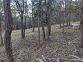
The trail improves dramatically, and now we are flowing northward, outward, enjoying trees and birds and dogs and snatches of strangers' overheard conversations and the mysterious phenomenon known as Dollywood.
Effortless we glide into Hurstbridge and then out of it, connecting with the road network at curious point, where the road narrows so much for a bridge that traffic alternately backs up in each direction. We watch the phenomenon for a few iterations, working out the pattern, then leap into the fray like a frog leaping onto fast-floating lilypad, and we skilfully avoid a flattening.
Then almost at once we are at the place. The embankment is so much higher and steeper than we imagined, and to be perfectly honest, we've done enough steep embankment scrambling for one day, so we back up a bit and find a way to creep our way up onto it across the grass. It's not at all clear what this piece of land is. Is it private property? There's a rusty barbed wire fence but no sign of any houses, just a few mounds of dung from some possibly unfamiliar animal.
Mindful of being extremely visible (high vis clothing sometimes has that effect) to neighbours in all directions, not to mention the busy evening traffic, we decide to make our dash as quick as possible. A quick commando roll under the barbed wire fence (helpfully some previous person had forced open a hole and left it propped open) and scurry quickly to the point. Our app flashes green, we take a couple of quick photos, we make a run for it. Our battery is low but our spirits are high.
In Hurstbridge, we round out the adventure with a series of terrible (but un-storyworthy) decisions involving takeaway noodles and eventually get a train home. There is a Herald-Sun to read, which seems fitting. Alas, our misadventures (actually, mostly the takeaway noodle bit) preclude the proposed pool party which will have to wait for another time.
Photos
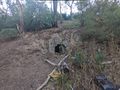
A mysterious hobbit hole.
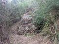
The path is getting sketchier...
...and sketchier
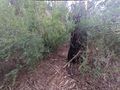
The creekside path becomes too non-existent to continue.
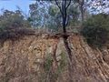
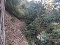
The final embankment as seen from the roadway.
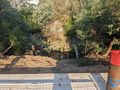
The case of the missing bridge.
The hash!
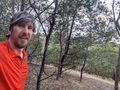
With me in it!


