Difference between revisions of "2022-04-12 59 17"
Enjoythecode (talk | contribs) (my first expedition) |
m (Location) |
||
| (9 intermediate revisions by 2 users not shown) | |||
| Line 1: | Line 1: | ||
| − | + | [[Image:{{{image|2022-04-12_59_17_enjoythecode_no_trespassing.jpg}}}|thumb|right]] | |
| − | + | {{meetup graticule | |
| − | [[Image:{{{image| | ||
| − | |||
| − | |||
| − | |||
| − | |||
| − | |||
| − | |||
| lat=59 | | lat=59 | ||
| lon=17 | | lon=17 | ||
| date=2022-04-12 | | date=2022-04-12 | ||
| − | }} | + | }} |
__NOTOC__ | __NOTOC__ | ||
| − | |||
| − | |||
| − | |||
| − | |||
| − | |||
| − | |||
| − | |||
| − | |||
| − | |||
| − | |||
| − | |||
| − | |||
| − | |||
| − | |||
| − | |||
| − | |||
| − | |||
| − | |||
| − | |||
| − | |||
| − | |||
| − | |||
| − | |||
| − | |||
| − | |||
| − | |||
| − | |||
| − | |||
| − | |||
| − | |||
| − | |||
| − | |||
| − | |||
| − | |||
| − | |||
| − | |||
| − | |||
| − | |||
| − | |||
| − | |||
| − | |||
| − | |||
| − | |||
| − | |||
| − | |||
| − | |||
| − | |||
| − | |||
| − | |||
| − | |||
| − | |||
| − | |||
| − | |||
| − | |||
| − | |||
| − | |||
| − | |||
| − | |||
| − | |||
| − | |||
| − | |||
| − | |||
| − | |||
| − | |||
| − | |||
| − | |||
| − | |||
| − | |||
| − | |||
== Location == | == Location == | ||
| Line 92: | Line 16: | ||
== Plans == | == Plans == | ||
| − | I scouted this hash as my first potential expedition in class in | + | I scouted this hash as my first potential expedition in class in [https://goo.gl/maps/28izyd4HXtqovLyVA Stockholm School of Economics]. A quick look at Google Maps, and I thought I could go up there with public transport with a combination of train and commuter rail. Then, I could either take a bus to go within 3 minutes walking distance of the hash, or I could walk the 2 kms from the rail stop to the hash. I also planned to pick up lunch nearby. |
== Expedition == | == Expedition == | ||
| Line 98: | Line 22: | ||
The public transport section was smooth, as the Swedish train system usually is. It was my first time in the commuter rail, and it felt like being in the airport due to the large amount of people traveling to Arlanda Airport. The weather was great for walking when I reached Sollentuna, so I walked to the proximity of the hash; about 20-30 minutes. | The public transport section was smooth, as the Swedish train system usually is. It was my first time in the commuter rail, and it felt like being in the airport due to the large amount of people traveling to Arlanda Airport. The weather was great for walking when I reached Sollentuna, so I walked to the proximity of the hash; about 20-30 minutes. | ||
| − | I could walk on the pavement up until 20 meters near the hash, unfortunately, the hash was in between two highways and the access to the middle was fenced off due to a construction. After [[ | + | I could walk on the pavement up until 20 meters near the hash, unfortunately, the hash was in between two highways and the access to the middle was fenced off due to a construction. After [[wikipedia:P hacking|walking back and forth in the closest tunnel and trying to get my accuracy to be bad enough to put me in the hash]], I stopped playing around -- this one seems to me to be a clear "no public access." |
I walked my path back, and caught the bus halfway down. There was a shopping center in the city center, where I had a nice chicken pizza with truffle mayo, and then I headed back to my stay in Bromma. | I walked my path back, and caught the bus halfway down. There was a shopping center in the city center, where I had a nice chicken pizza with truffle mayo, and then I headed back to my stay in Bromma. | ||
| + | |||
| + | == Photos == | ||
| + | |||
| + | <gallery perrow="5"> | ||
| + | Image:2022-04-12_59_17_enjoythecode_no_trespassing.jpg | Proof of fences preventing me from getting closer :( | ||
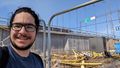
| + | Image:2022-04-12_59_17_enjoythecode_phacking-selfie.jpg | Me inside the tunnel, while ~going back and forth~ (p-hacking) | ||
| + | Image:2022-04-12_59_17_enjoythecode_mirror-grin.jpg | Am I doing mirror selfies correct? | ||
| + | </gallery> | ||
| + | |||
| + | == Achievements == | ||
| + | {{#vardefine:ribbonwidth|800px}} | ||
| + | |||
| + | <!-- Add any achievement ribbons you earned below, or remove this section --> | ||
| + | {{No trespassing |latitude=59 |longitude=17 |date=2022-04-12 |name= [[User:Enjoythecode|enjoythecode]] ([[User talk:Enjoythecode|talk]]) }} | ||
[[Category:Expeditions]] | [[Category:Expeditions]] | ||
[[Category:Not reached - No public access]] | [[Category:Not reached - No public access]] | ||
| + | [[Category:Coordinates not reached]] | ||
| + | [[Category:Expeditions with photos]] | ||
| + | {{location|SE|AB}} | ||
Latest revision as of 21:42, 13 April 2022

| Tue 12 Apr 2022 in 59,17: 59.4340560, 17.9231949 geohashing.info google osm bing/os kml crox |
Location
In the middle of a no-pedestrians road in Sollentuna, Stockholm.
Participants
Plans
I scouted this hash as my first potential expedition in class in Stockholm School of Economics. A quick look at Google Maps, and I thought I could go up there with public transport with a combination of train and commuter rail. Then, I could either take a bus to go within 3 minutes walking distance of the hash, or I could walk the 2 kms from the rail stop to the hash. I also planned to pick up lunch nearby.
Expedition
The public transport section was smooth, as the Swedish train system usually is. It was my first time in the commuter rail, and it felt like being in the airport due to the large amount of people traveling to Arlanda Airport. The weather was great for walking when I reached Sollentuna, so I walked to the proximity of the hash; about 20-30 minutes.
I could walk on the pavement up until 20 meters near the hash, unfortunately, the hash was in between two highways and the access to the middle was fenced off due to a construction. After walking back and forth in the closest tunnel and trying to get my accuracy to be bad enough to put me in the hash, I stopped playing around -- this one seems to me to be a clear "no public access."
I walked my path back, and caught the bus halfway down. There was a shopping center in the city center, where I had a nice chicken pizza with truffle mayo, and then I headed back to my stay in Bromma.
Photos
Proof of fences preventing me from getting closer :(

Me inside the tunnel, while ~going back and forth~ (p-hacking)
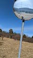
Am I doing mirror selfies correct?


Achievements
enjoythecode (talk) earned the No trespassing consolation prize
|