Difference between revisions of "2022-04-14 -37 144"
([live picture]' [https://openstreetmap.org/?mlat=-37.81930278&mlon=144.95468333&zoom=16 @-37.8193,144.9547]) |
|||
| (11 intermediate revisions by 3 users not shown) | |||
| Line 1: | Line 1: | ||
| − | + | [[File:2022-04-14 -37 144 stevage 1649928446681.jpg|thumb|left]] | |
| − | + | {{meetup graticule | |
| − | |||
| − | |||
| − | |||
| − | |||
| − | |||
| − | |||
| lat=-37 | | lat=-37 | ||
| lon=144 | | lon=144 | ||
| Line 13: | Line 7: | ||
}}<!-- edit as necessary --> | }}<!-- edit as necessary --> | ||
__NOTOC__ | __NOTOC__ | ||
| + | |||
| + | <br style="clear:left"> | ||
| + | |||
== Location == | == Location == | ||
| − | + | At the very edge of a tall building in the Melbourne CBD. | |
| − | |||
== Participants == | == Participants == | ||
| − | |||
| − | |||
| − | + | *[[User:Felix Dance|Felix Dance]] | |
| − | + | *[[User:Stevage|Stevage]] | |
== Expedition == | == Expedition == | ||
| − | + | It didn't look promising. A point 30 metres back from the footpath, either inside a building, or worse, on the boundary between two adjacent buildings. StreetView showed some kind of narrow alleyway, behind a very tall, and most probably, very locked, gate. And yet, in we went. For CBD hashes are incredibly rare (only one expedition, by [[2020-05-29 -37 144|Felix in 2020]]), and thus extra special. Felix estimated our chances of success at 30%. I said 5%. We both agreed there was a high chance of indeterminate result. | |
| − | == | + | We met at Princes Park and rode down together, surviving a journey through the [https://en.wikipedia.org/wiki/Haymarket_roundabout Roundabout of Death] to begin our fascinating foray into the urban exploration. |
| − | + | <gallery mode="packed" heights="300px"> | |
| + | File:2022-04-14 20_11_53-Bing Maps - Directions, trip planning, traffic cameras & more — Mozilla Firefox.png|According to Bing Maps, just outside the building. | ||
| + | File:2022-04-14 20_32_35-37°49'09.7_S 144°57'17.9_E - Google Maps — Mozilla Firefox.png|According to Google Maps...well, who knows, because the image is clearly taken from a big angle. That thing that looks like a park in the bottom right is actually a childcare several storeys up. | ||
| + | File:2022-04-14 20_31_51-geohashing.win — Mozilla Firefox.png|According to Mapbox, just outside the building. | ||
| + | </gallery> | ||
| + | |||
| + | === Attempt 1 === | ||
| + | After confirming that the gate in question was, indeed, locked (and very tall), we headed into the tall building to the east, wandering from floor to floor and trying to mentally map where we were within the building against the satellite imagery we had seen. We visited the Registry of Births, Deaths and Marriages on the 17th floor (fortunately no need to concoct a story to get inside, it wouldn't have gotten us closer), Yooralla on the 14th floor, a random stairwell, and the staff toilets on the ground floor. At various points, our phones reported us being only 10 metres from the point, but it's hard to take indoor position reports seriously. | ||
| − | + | <gallery mode="packed" heights="300px"> | |
| − | < | ||
| − | |||
| − | |||
| − | |||
| − | Image:2022-04-14_- | + | Image:2022-04-14_-37_144_stevage_1649928264096.jpg| Trying in vain to enter the laneway the easy way |
| − | Image:2022-04-14_- | + | Image:2022-04-14_-37_144_stevage_1649928292537.jpg| Registry of Births, Deaths and Marriages |
| + | Image:2022-04-14_-37_144_stevage_1649928308145.jpg|Exploring random stairwells | ||
Image:2022-04-14_-37_144_Felix Dance_1649924995108.jpg|Top of the building next to hash | Image:2022-04-14_-37_144_Felix Dance_1649924995108.jpg|Top of the building next to hash | ||
| − | Image:2022-04-14_- | + | Image:2022-04-14_-37_144_stevage_1649928318465.jpg|Amazing coffee machine |
| + | |||
| + | </gallery> | ||
| + | |||
| + | === Attempt 2 === | ||
| + | After looking more closely at the outside of the building, and checking Mapbox imagery instead of Google Maps, we concluded that probably the point was actually just outside the building, in that narrow alleyway. We headed around to Spencer St on the west and looked for a way that might get us close in. We eventually found a carpark attached to a hotel, which didn't look like we were supposed to walk into it (ok, it had a PEDESTRIANS PROHIBITED sign), but we strode purposefully in and weren't challenged. As carparks go, it was pretty interesting - old bluestone walls painted over, and a very large, strange object wrapped up in cardboard and stored next to some old bike racks. A giant fan? A chandelier? Who knows. Again, the phones were reporting a proximity of around 10 metres, but it didn't feel real. | ||
| − | Image:2022-04-14_- | + | <gallery mode="packed" heights="300px"> |
| + | Image:2022-04-14_-37_144_stevage_1649928357079.jpg|Striding purposefully into a carpark | ||
| + | |||
| + | Image:2022-04-14_-37_144_stevage_1649928369747.jpg|What on earth is hiding in this cardboard? Leave your answers in the comments below. | ||
| − | Image:2022-04-14_- | + | Image:2022-04-14_-37_144_Felix Dance_1649925020613.jpg|Steve in the carpark trying to reach the hash |
| + | </gallery> | ||
| − | + | === Attempt 3 === | |
| + | Continuing our circumnavigation, we now entered another carpark on the south side of the point, on Flinders Lane. Although the ground floor seemed too far east of the point, it looked like the upper floors extended much closer to it. We again strode in, and started scouting out a way to the upper floors. It felt a bit like a level of a first person shooter game - wandering around a carkpark looking at it from a completely non-parking-related perspective. | ||
| − | + | Eventually we were drawn towards a stairwell in the direction of the hash, and, stairwells being stairwells, decided to go upstairs. There was an emergency exit pleading with the public not to use it, but also secretly hinting to us that we should totally use it to get close to the hash. We couldn't let it down. | |
| − | + | We popped open the door, and, lo! We were at the other end of the laneway we had seen at the start! Jubilation! Felix dropped his high vis vest to keep the door from locking us out, while we scanned up and down to work out the exact point. This time, the phone location was reporting us as being much further away, but that didn't seem relevant. We could see from the shape of the building and the imagery the exact location of the hash, so we went there. And took a photo at it. Just to cover all his bases, Felix then climbed over another high gate next to the point, while I got nervous about security camera at the other end of the laneway. | |
| − | Image:2022-04-14_- | + | <gallery mode="packed" heights="300px"> |
| + | Image:2022-04-14_-37_144_stevage_1649928385231.jpg|Wandering into another carpark... | ||
| − | Image:2022-04-14_- | + | Image:2022-04-14_-37_144_stevage_1649928403682.jpg|Wandering more... |
| − | Image:2022-04-14_- | + | Image:2022-04-14_-37_144_stevage_1649928431870.jpg|The forbidden laneway is no longer forbidden! |
| − | Image:2022-04-14_- | + | Image:2022-04-14_-37_144_stevage_1649928446681.jpg|Success! |
| − | Image:2022-04-14_- | + | Image:2022-04-14_-37_144_stevage_1649928464455.jpg|Felix makes extra sure. |
| − | Image:2022-04-14_- | + | Image:2022-04-14_-37_144_Felix Dance_1649924960320.jpg|GPS not-quite proof |
| − | |||
</gallery> | </gallery> | ||
| − | == | + | === Aftermath === |
| − | + | We then followed our tracks back to our bikes, and discovered that most likely the gate that was "locked" was only locked from the outside - we could probably have just pushed it straight open to get out from the hash. We mulled this fact over on the way to beers at the Mitre Tavern, where fortune again favoured us with the last remaining outdoor table. Hooray! | |
| − | |||
| − | < | + | <gallery mode="packed" heights="300px"> |
| − | + | Image:2022-04-14_-37_144_Felix Dance_1649925035344.jpg|Celebrating at the pub | |
| − | + | </gallery> | |
| − | + | == Tracklog == | |
| + | [[File:2022-04-14 20_46_38-Geohash _ Ride _ Strava — Mozilla Firefox.png|800px|thumb|Nailed it.]] | ||
| + | {{Tracklog | 20220414_152452 Geohash CBD.gpx}} | ||
| + | Felix Dance's track (much worse resolution at the hash). | ||
| − | + | == Achievements == | |
| − | + | {{bicycle geohash | |
| − | [[ | + | | latitude = -37 |
| − | -- | + | | longitude = 144 |
| + | | date = 2022-04-14 | ||
| + | | name = [[User:Felix Dance]] and [[User:Stevage|Steve]] | ||
| + | | distance = 16 kms | ||
| + | | bothways = true | ||
| + | | image = Geohash 2022-02-18 -38 146 02 Hash.jpg | ||
| − | + | }} | |
| + | |||
| + | {{#vardefine:ribbonwidth|800px}} | ||
| − | |||
[[Category:Expeditions]] | [[Category:Expeditions]] | ||
| − | |||
[[Category:Expeditions with photos]] | [[Category:Expeditions with photos]] | ||
| − | |||
| − | |||
| − | |||
| − | |||
| − | |||
[[Category:Coordinates reached]] | [[Category:Coordinates reached]] | ||
| − | + | {{location|AU|VIC|ME}} | |
| − | |||
| − | |||
| − | |||
| − | |||
| − | |||
| − | |||
| − | |||
| − | |||
| − | |||
| − | |||
| − | |||
| − | |||
| − | |||
| − | |||
| − | |||
| − | |||
| − | |||
Latest revision as of 07:27, 2 August 2023

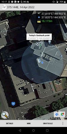
| Thu 14 Apr 2022 in -37,144: -37.8193677, 144.9549772 geohashing.info google osm bing/os kml crox |
Location
At the very edge of a tall building in the Melbourne CBD.
Participants
Expedition
It didn't look promising. A point 30 metres back from the footpath, either inside a building, or worse, on the boundary between two adjacent buildings. StreetView showed some kind of narrow alleyway, behind a very tall, and most probably, very locked, gate. And yet, in we went. For CBD hashes are incredibly rare (only one expedition, by Felix in 2020), and thus extra special. Felix estimated our chances of success at 30%. I said 5%. We both agreed there was a high chance of indeterminate result.
We met at Princes Park and rode down together, surviving a journey through the Roundabout of Death to begin our fascinating foray into the urban exploration.
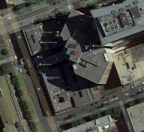
According to Bing Maps, just outside the building.
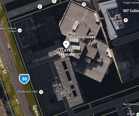
According to Google Maps...well, who knows, because the image is clearly taken from a big angle. That thing that looks like a park in the bottom right is actually a childcare several storeys up.
According to Mapbox, just outside the building.


Attempt 1
After confirming that the gate in question was, indeed, locked (and very tall), we headed into the tall building to the east, wandering from floor to floor and trying to mentally map where we were within the building against the satellite imagery we had seen. We visited the Registry of Births, Deaths and Marriages on the 17th floor (fortunately no need to concoct a story to get inside, it wouldn't have gotten us closer), Yooralla on the 14th floor, a random stairwell, and the staff toilets on the ground floor. At various points, our phones reported us being only 10 metres from the point, but it's hard to take indoor position reports seriously.
Trying in vain to enter the laneway the easy way
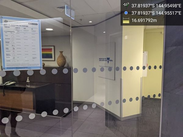
Registry of Births, Deaths and Marriages
Exploring random stairwells
Top of the building next to hash
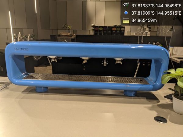
Amazing coffee machine


Attempt 2
After looking more closely at the outside of the building, and checking Mapbox imagery instead of Google Maps, we concluded that probably the point was actually just outside the building, in that narrow alleyway. We headed around to Spencer St on the west and looked for a way that might get us close in. We eventually found a carpark attached to a hotel, which didn't look like we were supposed to walk into it (ok, it had a PEDESTRIANS PROHIBITED sign), but we strode purposefully in and weren't challenged. As carparks go, it was pretty interesting - old bluestone walls painted over, and a very large, strange object wrapped up in cardboard and stored next to some old bike racks. A giant fan? A chandelier? Who knows. Again, the phones were reporting a proximity of around 10 metres, but it didn't feel real.
Striding purposefully into a carpark
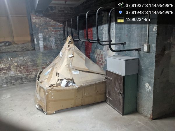
What on earth is hiding in this cardboard? Leave your answers in the comments below.
Steve in the carpark trying to reach the hash


Attempt 3
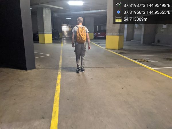
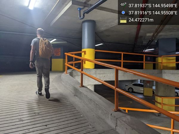
Continuing our circumnavigation, we now entered another carpark on the south side of the point, on Flinders Lane. Although the ground floor seemed too far east of the point, it looked like the upper floors extended much closer to it. We again strode in, and started scouting out a way to the upper floors. It felt a bit like a level of a first person shooter game - wandering around a carkpark looking at it from a completely non-parking-related perspective.
Eventually we were drawn towards a stairwell in the direction of the hash, and, stairwells being stairwells, decided to go upstairs. There was an emergency exit pleading with the public not to use it, but also secretly hinting to us that we should totally use it to get close to the hash. We couldn't let it down.
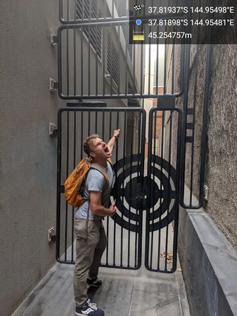
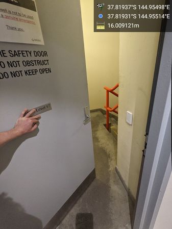
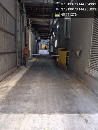
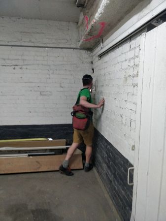
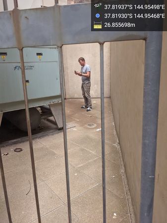
We popped open the door, and, lo! We were at the other end of the laneway we had seen at the start! Jubilation! Felix dropped his high vis vest to keep the door from locking us out, while we scanned up and down to work out the exact point. This time, the phone location was reporting us as being much further away, but that didn't seem relevant. We could see from the shape of the building and the imagery the exact location of the hash, so we went there. And took a photo at it. Just to cover all his bases, Felix then climbed over another high gate next to the point, while I got nervous about security camera at the other end of the laneway.
Wandering into another carpark...
Wandering more...
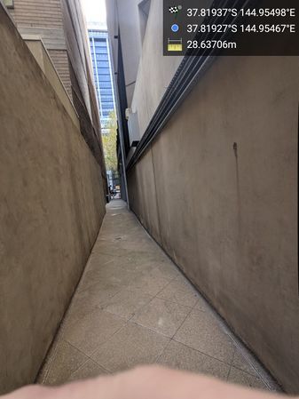
The forbidden laneway is no longer forbidden!

Success!
Felix makes extra sure.
GPS not-quite proof


Aftermath
We then followed our tracks back to our bikes, and discovered that most likely the gate that was "locked" was only locked from the outside - we could probably have just pushed it straight open to get out from the hash. We mulled this fact over on the way to beers at the Mitre Tavern, where fortune again favoured us with the last remaining outdoor table. Hooray!

Celebrating at the pub

Tracklog

Felix Dance's track (much worse resolution at the hash).
Achievements
User:Felix Dance and Steve earned the Bicycle geohash achievement
|