Difference between revisions of "2022-04-18 -37 145"
| Line 33: | Line 33: | ||
Image:2020-##-## ## ## Alpha.jpg | Witty Comment | Image:2020-##-## ## ## Alpha.jpg | Witty Comment | ||
--> | --> | ||
| − | |||
| − | |||
| + | <gallery> | ||
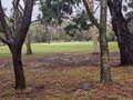
| + | File:PXL_20220418_013200799.jpg|Brave golfers. | ||
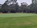
| + | File:PXL_20220418_013527701.jpg|Ducks! | ||
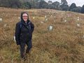
| + | File:PXL_20220418_013759127.jpg|Laura amongst a sea of saplings. Grow hard, trees, reach for the sky! | ||
</gallery> | </gallery> | ||
| Line 42: | Line 44: | ||
<!-- Add any achievement ribbons you earned below, or remove this section --> | <!-- Add any achievement ribbons you earned below, or remove this section --> | ||
| − | |||
| − | |||
| − | |||
| − | |||
| − | |||
| − | |||
| − | |||
| − | |||
| − | |||
| − | |||
| − | |||
| − | |||
| − | |||
| − | |||
[[Category:Expeditions]] | [[Category:Expeditions]] | ||
| − | |||
[[Category:Expeditions with photos]] | [[Category:Expeditions with photos]] | ||
| − | |||
| − | |||
| − | |||
| − | |||
| − | |||
[[Category:Coordinates reached]] | [[Category:Coordinates reached]] | ||
| − | |||
| − | |||
| − | |||
| − | |||
| − | |||
| − | |||
| − | |||
| − | |||
| − | |||
| − | |||
| − | |||
| − | |||
| − | |||
| − | |||
| − | |||
| − | |||
| − | |||
| − | |||
Revision as of 11:04, 18 April 2022

| Mon 18 Apr 2022 in -37,145: -37.7092232, 145.0397539 geohashing.info google osm bing/os kml crox |
Location
In Bundoora Park Public Golf Course
Participants
- Stevage
- Laura K
Plans
Expedition
On a very soggy Easter Monday, Laura was dragged along to her first geohash. After considering various transport options to get there, such as me cycling and Laura PT'ng, we ended up with Laura tramming to near my place, and me driving together.
That should have been the easy bit. Somehow, two very distracted people ended up "meeting" at two very different locations, and hilarity continued to ensue for half an hour while I drove around to where I thought Laura was, misunderstanding a second time. It would be even funnier if we both worked in the spatial industry...
Driving was uneventful. I parked an arbitrary distance from the hash in order to at least do a token walk (500 metres each way, very token). The grass was very squishy. Surprisingly, the rain had not vanquished all golfers, with one foursome gamely gaming away. And there were ducks too.
I had expected to find the point in the middle of a fairway, but it seems the course has been slightly reconfigured and that area is now being rehabilitated as bush. Many little saplings in tree guards. Good luck trees, may you grow tall and proud!
As such we actually overshot slightly and had to squish back to the point, getting to it very quickly. We then squished off to the car in a roundabout fashion, and of course soon found ourselves at a pub.
Tracklog
Photos
Brave golfers.
Ducks!
Laura amongst a sea of saplings. Grow hard, trees, reach for the sky!


