Difference between revisions of "2022-04-23 48 15"
(new report) |
m (→Participants: typo) |
||
| (6 intermediate revisions by 2 users not shown) | |||
| Line 1: | Line 1: | ||
| − | + | [[Image:{{{image| 2022-04-23_48_15_pah_010.jpeg}}}|thumb|right]]{{meetup graticule | |
| − | |||
| − | [[Image:{{{image| | ||
| − | |||
| − | |||
| − | |||
| − | |||
| − | |||
| − | |||
| lat={{#explode:{{SUBPAGENAME}}| |1}} | | lat={{#explode:{{SUBPAGENAME}}| |1}} | ||
| lon={{#explode:{{SUBPAGENAME}}| |2}} | | lon={{#explode:{{SUBPAGENAME}}| |2}} | ||
| date={{#explode:{{SUBPAGENAME}}| |0}} | | date={{#explode:{{SUBPAGENAME}}| |0}} | ||
| − | }} | + | }} |
__NOTOC__ | __NOTOC__ | ||
== Location == | == Location == | ||
| − | + | ||
| + | In a forest near [[wikipedia:Yspertal|Yspertal (Lower Austria)]]. | ||
== Participants == | == Participants == | ||
| − | + | * [[User:Pah|pah]] [[File:U+110DB.png|middle|6px|link=User:Pah]] ([[2022-04-23 48 14|prev]]|[[2022-04-27 48 14|next]]) | |
| − | -- | ||
== Plans == | == Plans == | ||
| − | + | ||
| + | Having both, time and a hashmobile at his disposal today, [[User:Pah|pah]] [[File:U+110DB.png|middle|6px|link=User:Pah]] aims for his first [[Multihash]] by visiting [[2022-04-23 48 14|(48,14)]] first and then proceed to [[2022-04-23 48 15|(48,15)]] afterwards. | ||
== Expedition == | == Expedition == | ||
| − | + | ||
| + | After around 1.5 hours of driving from the '''successful expedition''' to [[2022-04-23 48 14|(48,14)]], pah reached the vicinity of the (48,15) hashpoint at around 16:30. Again, the road became much smaller and also very steep after passing the last house (and its horses). The hashmobile sounded pretty unhappy even in small gears, so pah decided to leave the car close to the street / houses and continue on foot. According to GPS, he was still 1.9 kilometers away as the crow flies. pah‘s optimism sank slightly as he walked up the steep narrowing road, which then turned into a forest maintenance road after 500 meters: What will he be up to? Is it worth walking for several hours not knowing how the terrain will be? | ||
| + | |||
| + | Luckily, there were two joggers passing by, who asked him where he was headed. He explained his destination (and geohashing in general) and they gave him information on the path, the area of the hash and estimated a 30 minutes walk along the „Mariataferl“ pilgrim path. This sounded much better and so pah went on his way. | ||
| + | |||
| + | Indeed, pah reached the part of the forest with the hash after around 40 minutes of low intensity hiking in a beautiful spring evening sun. The hash dance took a while, likely due to the typical GPS accuracy issues in the forest (and hills), but finally he was able to capture proofs! He added a marker made of twigs on a nearby boulder and took some pictures before returning to the hashmobile. | ||
| + | |||
| + | On his way back, one of the horses (a beautiful and obviously pregnant mare) approached him and pah told her of his successful expedition. She seemed to enjoy pah‘s touch and pah is wondering, why there is no hash pony ribbon? After saying their goodbyes, pah returned to his hashmobile, drove back to the [[wikipedia:Danube|Danube]] river to follow the [https://de.wikipedia.org/wiki/%C3%96sterreichische_Romantikstra%C3%9Fe Österreichische Romantikstrasse] (Austrian Romantic Road) from Grein to Linz to complete his first successful multihash expedition! | ||
== Tracklog == | == Tracklog == | ||
| − | + | ||
| + | Combined tracklog for [[2022-04-23 48 14|(48,14)]] and [[2022-04-23 48 15|(48,15)]]: | ||
| + | |||
| + | {{tracklog | 2022-04-23 48 14+15 pah tracklog.gpx}} | ||
| + | [[Image:{{{image| 2022-04-23 48 14+15 pah tracklog.jpg}}}|640px]] | ||
== Photos == | == Photos == | ||
| − | |||
| − | |||
| − | |||
<gallery perrow="5"> | <gallery perrow="5"> | ||
| + | Image:2022-04-23 48 15 pah 001.jpeg | Leaving the hashmobile behind | ||
| + | Image:2022-04-23 48 15 pah 002.jpeg | Narrow and steep road ahead | ||
| + | Image:2022-04-23 48 15 pah 003.png | Remaining distance to walk | ||
| + | Image:2022-04-23 48 15 pah 004.jpeg | Pilgrim path towards the hash | ||
| + | Image:2022-04-23 48 15 pah 005.jpeg | Foot on hash | ||
| + | Image:2022-04-23 48 15 pah 006.png | Proof #1 | ||
| + | Image:2022-04-23 48 15 pah 007.png | Proof #2 | ||
| + | Image:2022-04-23 48 15 pah 008.jpeg | Hash marker | ||
| + | Image:2022-04-23 48 15 pah 009.jpeg | [[:Category:Grins|Stupid grin]]™ | ||
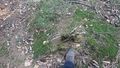
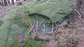
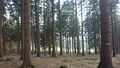
| + | Image:2022-04-23 48 15 pah 010.jpeg | Hash and marker | ||
| + | Image:2022-04-23 48 15 pah 011.jpeg | View from the hash back to the path | ||
| + | Image:2022-04-23 48 15 pah 012.jpeg | Curious (and pregnant) horse | ||
| + | Image:2022-04-23 48 15 pah 013.jpeg | Patting a hash<del>cat</del> mare | ||
| + | Image:2022-04-23 48 15 pah 014.jpeg | Back at the Danube river | ||
| + | Image:2022-04-23 48 15 pah 015.jpeg | View from Danube back in the direction of the hash | ||
| + | |||
</gallery> | </gallery> | ||
== Achievements == | == Achievements == | ||
{{#vardefine:ribbonwidth|800px}} | {{#vardefine:ribbonwidth|800px}} | ||
| − | |||
| − | |||
| − | |||
| − | |||
| − | |||
| − | + | {{Multihash | |
| + | | latitude1 = 48 | ||
| + | | longitude1 = 14 | ||
| + | | latitude2 = 48 | ||
| + | | longitude2 = 15 | ||
| + | | date = 2022-04-23 | ||
| + | | name = [[User:Pah|pah]] [[File:U+110DB.png|middle|6px|link=User:Pah]] | ||
| + | | image = 2022-04-23 48 14+15 pah tracklog.jpg | ||
| + | }} | ||
| − | + | {{Minesweeper geohash | |
| − | + | | graticule = Linz, Austria | |
| − | [[ | + | | ranknumber = 1 |
| − | + | | e = true | |
| + | | name = [[User:Pah|pah]] [[File:U+110DB.png|middle|6px|link=User:Pah]] | ||
| + | }} | ||
| − | |||
| − | |||
[[Category:Expeditions]] | [[Category:Expeditions]] | ||
| − | |||
[[Category:Expeditions with photos]] | [[Category:Expeditions with photos]] | ||
| − | |||
| − | |||
| − | |||
| − | |||
| − | |||
[[Category:Coordinates reached]] | [[Category:Coordinates reached]] | ||
| − | + | {{location|AT|NÖ|ME}} | |
| − | |||
| − | |||
| − | |||
| − | |||
| − | |||
| − | |||
| − | |||
| − | |||
| − | |||
| − | |||
| − | |||
| − | |||
| − | |||
| − | |||
| − | |||
| − | |||
| − | |||
Latest revision as of 21:28, 27 April 2022

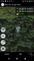
| Sat 23 Apr 2022 in 48,15: 48.2616833, 15.0849674 geohashing.info google osm bing/os kml crox |
Location
In a forest near Yspertal (Lower Austria).
Participants
Plans
Having both, time and a hashmobile at his disposal today, pah ![]() aims for his first Multihash by visiting (48,14) first and then proceed to (48,15) afterwards.
aims for his first Multihash by visiting (48,14) first and then proceed to (48,15) afterwards.
Expedition
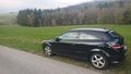
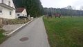
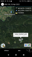
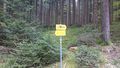
After around 1.5 hours of driving from the successful expedition to (48,14), pah reached the vicinity of the (48,15) hashpoint at around 16:30. Again, the road became much smaller and also very steep after passing the last house (and its horses). The hashmobile sounded pretty unhappy even in small gears, so pah decided to leave the car close to the street / houses and continue on foot. According to GPS, he was still 1.9 kilometers away as the crow flies. pah‘s optimism sank slightly as he walked up the steep narrowing road, which then turned into a forest maintenance road after 500 meters: What will he be up to? Is it worth walking for several hours not knowing how the terrain will be?
Luckily, there were two joggers passing by, who asked him where he was headed. He explained his destination (and geohashing in general) and they gave him information on the path, the area of the hash and estimated a 30 minutes walk along the „Mariataferl“ pilgrim path. This sounded much better and so pah went on his way.
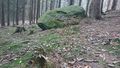
Indeed, pah reached the part of the forest with the hash after around 40 minutes of low intensity hiking in a beautiful spring evening sun. The hash dance took a while, likely due to the typical GPS accuracy issues in the forest (and hills), but finally he was able to capture proofs! He added a marker made of twigs on a nearby boulder and took some pictures before returning to the hashmobile.
On his way back, one of the horses (a beautiful and obviously pregnant mare) approached him and pah told her of his successful expedition. She seemed to enjoy pah‘s touch and pah is wondering, why there is no hash pony ribbon? After saying their goodbyes, pah returned to his hashmobile, drove back to the Danube river to follow the Österreichische Romantikstrasse (Austrian Romantic Road) from Grein to Linz to complete his first successful multihash expedition!
Tracklog
Combined tracklog for (48,14) and (48,15):

Photos
Leaving the hashmobile behind
Narrow and steep road ahead
Remaining distance to walk
Pilgrim path towards the hash
Foot on hash
Proof #1

Proof #2
Hash marker
Hash and marker
View from the hash back to the path
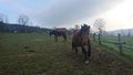
Curious (and pregnant) horse

Patting a hash
catmare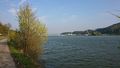
Back at the Danube river

View from Danube back in the direction of the hash


Achievements
pah
|
pah
|