Difference between revisions of "2022-04-29 51 9"
m |
(→Photos) |
||
| (One intermediate revision by the same user not shown) | |||
| Line 20: | Line 20: | ||
== Expedition == | == Expedition == | ||
<!-- how it all turned out. your narrative goes here --> | <!-- how it all turned out. your narrative goes here --> | ||
| − | -- | + | This indeed was a nice walk through some delightful nature, little over 7 kilometers in the end, which led me in a wonderful forest, pretty undisturbed from harvesters et al... Right from the start, the terrain was pretty steep - had to climb some 150 meters and got sweaty for real, but once I got ''up there'' the road was quite ok and even... Approaching the hash, I noticed that I had to go down some 25 meters again, through rather wild nature and had some problems to locate the accurate coordinates - the '''hashdance''' took some 5 minutes, but then I got onto less than one meter, which is pretty well in the middle of a forest... |
| + | |||
| + | The hash was a leftover of a tree - cut down some years ago probably - a really nice spot, which made me happy to have done this expedition! Didn't encounter any animals, which I sort of expected in this area - maybe next time hehe... | ||
| + | |||
| + | Right now, I am thinking about hiding some geocaches along the route I walked today - let's see if this will happen or not... | ||
== Photos == | == Photos == | ||
| − | |||
<gallery> | <gallery> | ||
| − | Image:2022-04-29_51_9_001.jpg| | + | Image:2022-04-29_51_9_001.jpg|On my way to the hash |
| − | Image:2022-04-29_51_9_002.jpg| | + | Image:2022-04-29_51_9_002.jpg|Entering the forest |
| − | Image:2022-04-29_51_9_003.jpg| | + | Image:2022-04-29_51_9_003.jpg|Through the woods |
| − | Image:2022-04-29_51_9_004.jpg| | + | Image:2022-04-29_51_9_004.jpg|Some 250 meters near the hash |
| − | Image:2022-04-29_51_9_005.jpg| | + | Image:2022-04-29_51_9_005.jpg|Undisturbed nature |
| − | Image:2022-04-29_51_9_006.jpg| | + | Image:2022-04-29_51_9_006.jpg|The hash |
| − | Image:2022-04-29_51_9_007.jpg| | + | Image:2022-04-29_51_9_007.jpg|The hasher |
| − | Image:2022-04-29_51_9_008.jpg| | + | Image:2022-04-29_51_9_008.jpg|Hash surroundings |
| + | Image:2022-04-29_51_9_009.jpg|Proof | ||
</gallery> | </gallery> | ||
[[Category:Expeditions]] | [[Category:Expeditions]] | ||
[[Category:Expeditions with photos]] | [[Category:Expeditions with photos]] | ||
| − | [[Category:Coordinates reached | + | [[Category:Coordinates reached]] |
| − | |||
{{location|DE|HE|HR}} | {{location|DE|HE|HR}} | ||
Latest revision as of 16:57, 29 April 2022
| Fri 29 Apr 2022 in 51,9: 51.0593787, 9.5239315 geohashing.info google osm bing/os kml crox |
Location
In a forest south of Beiseförth
Participants
Plans
After work, I will drive to Beiseförth and do a nice walk to the hash.
Expedition
This indeed was a nice walk through some delightful nature, little over 7 kilometers in the end, which led me in a wonderful forest, pretty undisturbed from harvesters et al... Right from the start, the terrain was pretty steep - had to climb some 150 meters and got sweaty for real, but once I got up there the road was quite ok and even... Approaching the hash, I noticed that I had to go down some 25 meters again, through rather wild nature and had some problems to locate the accurate coordinates - the hashdance took some 5 minutes, but then I got onto less than one meter, which is pretty well in the middle of a forest...
The hash was a leftover of a tree - cut down some years ago probably - a really nice spot, which made me happy to have done this expedition! Didn't encounter any animals, which I sort of expected in this area - maybe next time hehe...
Right now, I am thinking about hiding some geocaches along the route I walked today - let's see if this will happen or not...
Photos
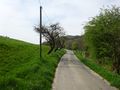
On my way to the hash
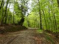
Entering the forest
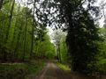
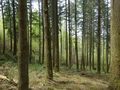
Through the woods
Some 250 meters near the hash
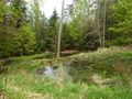
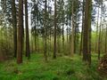
Undisturbed nature
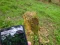
The hash
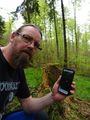
The hasher
Hash surroundings

Proof


