Difference between revisions of "2022-05-10 48 7"
From Geohashing
(Start expedition) |
(→Expedition) |
||
| (5 intermediate revisions by 3 users not shown) | |||
| Line 5: | Line 5: | ||
}} | }} | ||
== Location == | == Location == | ||
| − | In the middle of a | + | In the middle of a cornfield in [[wikipedia:Ohnenheim|Ohnenheim]]. |
== Participants == | == Participants == | ||
| Line 12: | Line 12: | ||
== Plans == | == Plans == | ||
I'm going to cycle to the geohash after work. I should reach the coordinates around 18:20. | I'm going to cycle to the geohash after work. I should reach the coordinates around 18:20. | ||
| + | |||
| + | == Expedition == | ||
| + | I cycled 13 km from Sélestat to Ohnenheim, stopped near a cornfield and walked a couple hundred meters to the geohash. The cornstalks were still short, so I was easy to reach the coordinates. | ||
| + | |||
| + | After recording proof, I made a detour via Sundhouse on my way back home, cycling 39 km in total. | ||
| + | |||
| + | == Photos == | ||
| + | <gallery> | ||
| + | Image:2022-05-10 48 7 01.jpg | In Ohnenheim | ||
| + | Image:2022-05-10 48 7 02.jpg | My bicycle near the geohash | ||
| + | Image:2022-05-10 48 7 03.png | Coordinates reached | ||
| + | Image:2022-05-10 48 7 04.jpg | Surroundings (East) | ||
| + | Image:2022-05-10 48 7 05.jpg | Surroundings (West) | ||
| + | Image:2022-05-10 48 7 06.jpg | Stupid grin | ||
| + | </gallery> | ||
| + | |||
| + | == Achievements == | ||
| + | {{#vardefine:ribbonwidth|100%}} | ||
| + | {{land geohash | ||
| + | | latitude = 48 | ||
| + | | longitude = 7 | ||
| + | | date = 2022-05-10 | ||
| + | | name = [[User:Baarde|Baarde]] | ||
| + | }} | ||
| + | {{bicycle geohash | ||
| + | | latitude = 48 | ||
| + | | longitude = 7 | ||
| + | | date = 2022-05-10 | ||
| + | | name = [[User:Baarde|Baarde]] | ||
| + | | distance = 39 km | ||
| + | | bothways = true | ||
| + | }} | ||
| + | |||
__NOTOC__ | __NOTOC__ | ||
[[Category:Expeditions]] | [[Category:Expeditions]] | ||
| + | [[Category:Coordinates reached]] | ||
| + | [[Category:Expeditions with photos]] | ||
| + | {{location|FR|67}} | ||
Latest revision as of 19:08, 31 July 2022
| Tue 10 May 2022 in 48,7: 48.1680929, 7.5252451 geohashing.info google osm bing/os kml crox |
Location
In the middle of a cornfield in Ohnenheim.
Participants
Plans
I'm going to cycle to the geohash after work. I should reach the coordinates around 18:20.
Expedition
I cycled 13 km from Sélestat to Ohnenheim, stopped near a cornfield and walked a couple hundred meters to the geohash. The cornstalks were still short, so I was easy to reach the coordinates.
After recording proof, I made a detour via Sundhouse on my way back home, cycling 39 km in total.
Photos
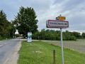
In Ohnenheim
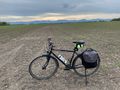
My bicycle near the geohash
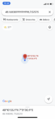
Coordinates reached
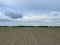
Surroundings (East)
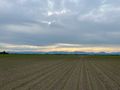
Surroundings (West)
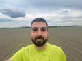
Stupid grin


Achievements
Baarde earned the Land geohash achievement
|
Baarde earned the Bicycle geohash achievement
|