Difference between revisions of "2022-05-14 41 -79"
From Geohashing
(→Plans) |
m (→Participants) |
||
| (15 intermediate revisions by 2 users not shown) | |||
| Line 22: | Line 22: | ||
--> | --> | ||
| − | [[kc3qja]] | + | [[User:kc3qja|kc3qja]] |
== Plans == | == Plans == | ||
| Line 31: | Line 31: | ||
== Expedition == | == Expedition == | ||
<!-- how it all turned out. your narrative goes here. --> | <!-- how it all turned out. your narrative goes here. --> | ||
| + | |||
| + | Took the car to Bullion where me and my stepdad got out and walked a quarter mile to the hash. Didn't run into anyone except a shack, and didn't know if we were trespassing or not. | ||
== Tracklog == | == Tracklog == | ||
<!-- if your GPS device keeps a log, you may use Template:Tracklog, post a link here, or both --> | <!-- if your GPS device keeps a log, you may use Template:Tracklog, post a link here, or both --> | ||
| + | |||
| + | I don't know what a tracklog is. Here is a photo of my phone showing proof of location. | ||
| + | |||
| + | [[File:A1BDE15C-2C7E-4362-BAF6-11A582EBFBF1.jpeg|400px]] | ||
== Photos == | == Photos == | ||
| Line 40: | Line 46: | ||
--> | --> | ||
<gallery perrow="5"> | <gallery perrow="5"> | ||
| + | Image:F9F6D92D-801E-4D5B-B2D5-86F64B0F3FAB.jpeg | Trail at the hash.[[Category: Meetup on 2022-05-14]][[Category: Meetup in 41 -79]] | ||
| + | Image:E5874122-FE95-487D-B5C7-6EE62A05FCB3.jpeg | Photo taken at the hash. [[Category: Meetup on 2022-05-14]][[Category: Meetup in 41 -79]] | ||
</gallery> | </gallery> | ||
| Line 45: | Line 53: | ||
{{#vardefine:ribbonwidth|800px}} | {{#vardefine:ribbonwidth|800px}} | ||
<!-- Add any achievement ribbons you earned below, or remove this section --> | <!-- Add any achievement ribbons you earned below, or remove this section --> | ||
| + | {{land geohash | ||
| − | + | | latitude = 41 | |
| − | + | | longitude = -79 | |
| − | + | | date = 2022-05-14 | |
| − | + | | name = kc3qja | |
| − | + | | image = | |
| − | + | }} | |
| − | |||
| − | |||
| − | |||
| − | |||
| − | |||
| − | |||
| − | + | I was out standing in the field. | |
| + | [[File:2016-04-22 52 1 Sourcerer Trophy.jpg|400px]] | ||
[[Category:Expeditions]] | [[Category:Expeditions]] | ||
| − | |||
[[Category:Expeditions with photos]] | [[Category:Expeditions with photos]] | ||
| − | |||
| − | |||
| − | |||
| − | |||
| − | |||
[[Category:Coordinates reached]] | [[Category:Coordinates reached]] | ||
| − | + | {{location|US|PA|VE}} | |
| − | |||
| − | |||
| − | |||
| − | |||
| − | |||
| − | |||
| − | |||
| − | |||
| − | |||
| − | |||
| − | |||
| − | |||
| − | |||
| − | |||
| − | |||
| − | |||
| − | |||
| − | |||
| − | |||
| − | |||
| − | |||
| − | |||
| − | |||
| − | |||
| − | |||
| − | |||
| − | |||
| − | |||
| − | |||
| − | |||
| − | |||
| − | |||
| − | |||
| − | |||
| − | |||
Latest revision as of 15:50, 15 May 2022
| Sat 14 May 2022 in 41,-79: 41.2534716, -79.8995156 geohashing.info google osm bing/os kml crox |
Location
The hash was in a field near Bullion, PA.
Participants
Plans
The plan was to just go there. I wasn't sure if it was posted or not, so I had to find out.
Expedition
Took the car to Bullion where me and my stepdad got out and walked a quarter mile to the hash. Didn't run into anyone except a shack, and didn't know if we were trespassing or not.
Tracklog
I don't know what a tracklog is. Here is a photo of my phone showing proof of location.

Photos
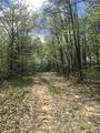
Trail at the hash.
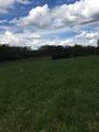
Photo taken at the hash.


Achievements
kc3qja earned the Land geohash achievement
|
I was out standing in the field.
