Difference between revisions of "2022-05-19 51 9"
| Line 20: | Line 20: | ||
== Expedition == | == Expedition == | ||
<!-- how it all turned out. your narrative goes here --> | <!-- how it all turned out. your narrative goes here --> | ||
| − | + | Before getting to work I drove through Hessisch Lichtenau and got on the road to Günsterode and parked my car straight near the path that would lead to the geohash directly. It was only a 2 km hike to reach todays hash, which was a tree-trunk, only some 3 meters off the path, so I had to climb a little bit to get to the exact coordinates and managed to record proof within less than two minutes. An easy one. Again. | |
| + | |||
| + | Took some pics of the surrounding area, and then walked back to my car, arriving at work just at time... Nothing more to write actually... | ||
== Photos == | == Photos == | ||
<gallery> | <gallery> | ||
| − | Image:2022-05- | + | Image:2022-05-19_51_9_001.jpg|On my way to the hash |
| − | Image:2022-05- | + | Image:2022-05-19_51_9_002.jpg|The hash |
| − | Image:2022-05- | + | Image:2022-05-19_51_9_003.jpg|The hasher at the hash location |
| − | Image:2022-05- | + | Image:2022-05-19_51_9_004.jpg|View from the hash - downhill |
| − | Image:2022-05- | + | Image:2022-05-19_51_9_005.jpg|View from the hash - uphill |
| − | Image:2022-05- | + | Image:2022-05-19_51_9_006.jpg|A lonely bench nearby |
| − | Image:2022-05- | + | Image:2022-05-19_51_9_007.jpg|Parking lot |
| − | Image:2022-05- | + | Image:2022-05-19_51_9_008.jpg|Proof |
</gallery> | </gallery> | ||
| Line 37: | Line 39: | ||
[[Category:Expeditions with photos]] | [[Category:Expeditions with photos]] | ||
[[Category:Coordinates reached]] | [[Category:Coordinates reached]] | ||
| − | |||
| − | |||
{{location|DE|HE|HR}} | {{location|DE|HE|HR}} | ||
Latest revision as of 18:43, 20 May 2022
| Thu 19 May 2022 in 51,9: 51.1708467, 9.6887653 geohashing.info google osm bing/os kml crox |
Location
In a forest south of Hessisch Lichtenau
Participants
Plans
I will visit this hash before going to work...
Expedition
Before getting to work I drove through Hessisch Lichtenau and got on the road to Günsterode and parked my car straight near the path that would lead to the geohash directly. It was only a 2 km hike to reach todays hash, which was a tree-trunk, only some 3 meters off the path, so I had to climb a little bit to get to the exact coordinates and managed to record proof within less than two minutes. An easy one. Again.
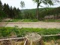
Took some pics of the surrounding area, and then walked back to my car, arriving at work just at time... Nothing more to write actually...
Photos
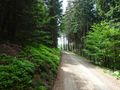
On my way to the hash
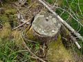
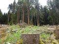
The hash
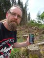
The hasher at the hash location
View from the hash - downhill
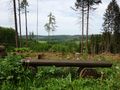
View from the hash - uphill
A lonely bench nearby
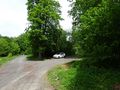
Parking lot
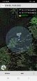
Proof


