Difference between revisions of "2022-05-30 40 -111"
From Geohashing
(One image) |
(Add GPS image) |
||
| Line 21: | Line 21: | ||
<gallery perrow="5"> | <gallery perrow="5"> | ||
2022-05-30 40 -111 grins.jpg | Grins | 2022-05-30 40 -111 grins.jpg | Grins | ||
| + | 2022-05-30 40 -111 gps.png | GPS | ||
</gallery> | </gallery> | ||
== Achievements == | == Achievements == | ||
{{#vardefine:ribbonwidth|800px}} | {{#vardefine:ribbonwidth|800px}} | ||
| − | |||
[[Category:Expeditions]] | [[Category:Expeditions]] | ||
| − | [[Category:Expeditions with photos]] | + | [[Category:Expeditions with photos]] |
| − | |||
| − | |||
| − | |||
| − | |||
| − | |||
[[Category:Coordinates reached]] | [[Category:Coordinates reached]] | ||
{{location|US|UT|UT}} | {{location|US|UT|UT}} | ||
Latest revision as of 02:56, 12 July 2022

| Mon 30 May 2022 in 40,-111: 40.3211281, -111.6763848 geohashing.info google osm bing/os kml crox |
Location
Near the west road inside the south portion of Orem City Cemetery. On Memorial Day!
Participants
Plans
Walk over to this portion while visiting graves in the cemetery.
Expedition
We walked over to this portion after visiting graves in the cemetery.
Photos
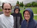
Grins
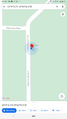
GPS
