Difference between revisions of "2022-06-15 51 9"
(Created page with "{{meetup graticule | lat=51 | lon=9 | date=2022-06-15 }} <!-- edit as necessary --> __NOTOC__ == Location == In a forest south-west of Waldkappel == Participants == User...") |
|||
| Line 20: | Line 20: | ||
== Expedition == | == Expedition == | ||
<!-- how it all turned out. your narrative goes here --> | <!-- how it all turned out. your narrative goes here --> | ||
| − | + | Last few weeks were pretty bad luck concering geohashing for me - either the hashpoints were way to far away from my home, or (when getting pretty near to my home actually) were in the middle of fields or on private property... Guess all of us geohashers know this problem very well, we're always ready to go for a hash, but if the coords don't fit, we'll have to wait for tomorrow, and the day after and again the day after that, oh, you know what I mean... | |
| − | |||
| − | + | Today was a good one - getting a parking lot right on my way to work and do a 2 km walk to the hash, almost in a straight line. It was warm outside and the road didn't offer any shadows and was climbing all the way... Pretty sweaty I reached the coordinates after 25 minutes, located the hash right on the path and did some pics for proof. Then I walked back, downwards, pretty easy and got back in my car in time to drive to work to do the late shift until 10 pm... So, an easy one again, but finally a hash after such a long time! | |
== Photos == | == Photos == | ||
<gallery> | <gallery> | ||
| − | Image:2022- | + | Image:2022-06-15_51_9_001.jpg|On my way to the hash |
| − | Image:2022- | + | Image:2022-06-15_51_9_002.jpg|The hash |
| − | Image:2022- | + | Image:2022-06-15_51_9_003.jpg|The hasher at the hash location |
| − | Image:2022- | + | Image:2022-06-15_51_9_004.jpg|View from the hash |
| − | Image:2022- | + | Image:2022-06-15_51_9_005.jpg|On my way back |
| − | Image:2022- | + | Image:2022-06-15_51_9_006.jpg|A blue sky |
| − | Image:2022- | + | Image:2022-06-15_51_9_007.jpg|Parking lot |
| − | Image:2022- | + | Image:2022-06-15_51_9_008.jpg|Proof |
</gallery> | </gallery> | ||
| Line 40: | Line 39: | ||
[[Category:Expeditions with photos]] | [[Category:Expeditions with photos]] | ||
[[Category:Coordinates reached]] | [[Category:Coordinates reached]] | ||
| − | |||
| − | |||
{{location|DE|HE|ESW}} | {{location|DE|HE|ESW}} | ||
Latest revision as of 21:37, 15 June 2022
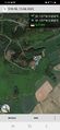
| Wed 15 Jun 2022 in 51,9: 51.1370766, 9.8497507 geohashing.info google osm bing/os kml crox |
Location
In a forest south-west of Waldkappel
Participants
Plans
I will visit this hash before going to work... Long time gone since a hashpoint was that good for me...
Expedition
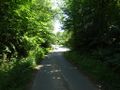
Last few weeks were pretty bad luck concering geohashing for me - either the hashpoints were way to far away from my home, or (when getting pretty near to my home actually) were in the middle of fields or on private property... Guess all of us geohashers know this problem very well, we're always ready to go for a hash, but if the coords don't fit, we'll have to wait for tomorrow, and the day after and again the day after that, oh, you know what I mean...
Today was a good one - getting a parking lot right on my way to work and do a 2 km walk to the hash, almost in a straight line. It was warm outside and the road didn't offer any shadows and was climbing all the way... Pretty sweaty I reached the coordinates after 25 minutes, located the hash right on the path and did some pics for proof. Then I walked back, downwards, pretty easy and got back in my car in time to drive to work to do the late shift until 10 pm... So, an easy one again, but finally a hash after such a long time!
Photos
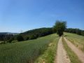
On my way to the hash

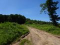
The hash

The hasher at the hash location
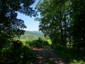
View from the hash
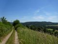
On my way back
A blue sky
Parking lot
Proof


