Difference between revisions of "2022-07-08 47 -122"
From Geohashing
([live picture]Looking south [https://openstreetmap.org/?mlat=47.61133397&mlon=-122.21106297&zoom=16 @47.6113,-122.2111]) |
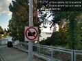
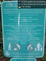
([live picture]Symbols to decode [https://openstreetmap.org/?mlat=47.61195097&mlon=-122.21160700&zoom=16 @47.6120,-122.2116]) |
||
| Line 38: | Line 38: | ||
Image:2022-07-08_47_-122_thomcat_1657336518015.jpg|Looking south [https://openstreetmap.org/?mlat=47.61133397&mlon=-122.21106297&zoom=16 @47.6113,-122.2111] | Image:2022-07-08_47_-122_thomcat_1657336518015.jpg|Looking south [https://openstreetmap.org/?mlat=47.61133397&mlon=-122.21106297&zoom=16 @47.6113,-122.2111] | ||
| + | |||
| + | Image:2022-07-08_47_-122_thomcat_1657336629824.jpg|Symbols to decode [https://openstreetmap.org/?mlat=47.61195097&mlon=-122.21160700&zoom=16 @47.6120,-122.2116] | ||
</gallery> | </gallery> | ||
Revision as of 03:17, 9 July 2022
| Fri 8 Jul 2022 in Seattle: 47.6115230, -122.2101686 geohashing.info google osm bing/os kml crox |
Location
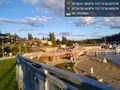
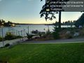
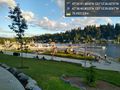
Meydenbaur Park in Bellevue, near Lake Washington
Participants
Plans
Today, but otherwise TBD
Expedition
Tracklog
Photos
A sign of the times @47.6118,-122.2103

Geohasher @47.6115,-122.2102
Flags @47.6108,-122.2107
Looking west @47.6113,-122.2111
Looking south @47.6113,-122.2111
Symbols to decode @47.6120,-122.2116


