Difference between revisions of "2022-07-21 58 5"
From Geohashing
(→Tracklog) |
(→Photos) |
||
| Line 40: | Line 40: | ||
Image:2022-07-21_58_5_Pica42_1658400194268.jpg|Bergsagel [https://openstreetmap.org/?mlat=58.93513780&mlon=5.93527160&zoom=16 @58.9351,5.9353] | Image:2022-07-21_58_5_Pica42_1658400194268.jpg|Bergsagel [https://openstreetmap.org/?mlat=58.93513780&mlon=5.93527160&zoom=16 @58.9351,5.9353] | ||
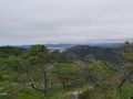
| + | Image:20220721 58 5 1.jpg|View from the trail | ||
| + | Image:20220721 58 5 2.jpg|thumb|I found a lot of blueberries along the path. | ||
| + | Image:20220721 58 5 3.jpg|thumb|Part of the trail. | ||
| + | Image:20220721 58 5 4.jpg|thumb|View from the hash. | ||
| + | Image:20220721 58 5 5.jpg|thumb|View from the hash. | ||
| + | Image:20220721 58 5 6.jpg|thumb|View from the hash. | ||
| + | |||
</gallery> | </gallery> | ||
Revision as of 17:29, 21 July 2022
| Thu 21 Jul 2022 in 58,5: 58.9351553, 5.9353144 geohashing.info google osm bing/os kml crox |
Location
Litla Vårlifjellet, Sandnes, Norway
Participants
Plans
Expedition
Tracklog
Photos

Bergsagel @58.9351,5.9353
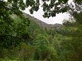
View from the trail
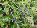
I found a lot of blueberries along the path.
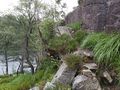
Part of the trail.
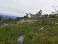
View from the hash.
View from the hash.
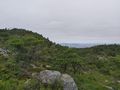
View from the hash.


Achievements