Difference between revisions of "2022-07-26 53 -113"
([live picture]More proof) |
(→Photos) |
||
| Line 43: | Line 43: | ||
Image:2022-07-26_53_-113_b_cereus_1658894812584.jpg|Proof | Image:2022-07-26_53_-113_b_cereus_1658894812584.jpg|Proof | ||
| − | Image:2022-07-26_53_-113_b_cereus_1658895986454.jpg| | + | Image:2022-07-26_53_-113_b_cereus_1658895986454.jpg|Stupid grin |
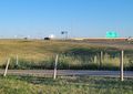
Image:2022-07-26_53_-113_b_cereus_1658896154785.jpg|The location was just on the other side of the bike path | Image:2022-07-26_53_-113_b_cereus_1658896154785.jpg|The location was just on the other side of the bike path | ||
Revision as of 04:36, 27 July 2022
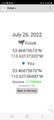
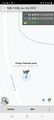
| Tue 26 Jul 2022 in 53,-113: 53.4687567, -113.6313732 geohashing.info google osm bing/os kml crox |
Location
Only 2.5 km from home! Off the side of an off-ramp of the Anthony Henday Ring road that leads to the fancy neighborhood of Cameron Heights.
Participants
Plans
Should just be a quick drive over the bridge and back. 2.5 km as the crow flies, but a 7 km drive.
Expedition
Probably the easiest hash I've done! The drive there took only 7 minutes. I parked about 20 meters from the spot and walked along the side of the road to the hashpoint. The drive back was entirely different though. Traffic was stop and go and only moving at 5 km/h. There was an collision in the middle of the bridge and only 1 lane could go by. It only delayed my journey home by 30 minutes, so it was still a very easy hash.
Tracklog
Photos
Proof

Stupid grin
The location was just on the other side of the bike path
More proof


Achievements