Difference between revisions of "2022-07-31 52 5"
From Geohashing
(→Location) |
|||
| Line 1: | Line 1: | ||
| − | + | [[Image:{{{image|2022-07-31 52 5 surroundings.jpeg}}}|thumb|left]] | |
| − | + | {{meetup graticule | |
| − | |||
| − | |||
| − | |||
| − | |||
| − | |||
| − | |||
| lat={{#explode:{{SUBPAGENAME}}| |1}} | | lat={{#explode:{{SUBPAGENAME}}| |1}} | ||
| lon={{#explode:{{SUBPAGENAME}}| |2}} | | lon={{#explode:{{SUBPAGENAME}}| |2}} | ||
| Line 17: | Line 11: | ||
== Participants == | == Participants == | ||
| − | + | [[User:Xnyhps|Xnyhps]] ([[User talk:Xnyhps|talk]]) | |
| − | |||
== Plans == | == Plans == | ||
| − | + | === xnyhps === | |
| + | I was planning to make a cycling trip anyway, so when the hash showed up as being on the grass between the road and the adjacent cycling path I decided to go for it. Planned a route from Zeist, via De Bilt to Utrecht which would take me past the hash point. | ||
== Expedition == | == Expedition == | ||
| − | + | Everything went as planned, although a bit more rainy than the forecast had shown. | |
| − | |||
| − | |||
| − | |||
== Photos == | == Photos == | ||
| − | |||
| − | |||
| − | |||
<gallery perrow="5"> | <gallery perrow="5"> | ||
| + | Image:2022-07-31 52 5 proof.png | Proof | ||
| + | Image:2022-07-31 52 5 hash.jpeg | The location of the hash | ||
| + | Image:2022-07-31 52 5 surroundings.jpeg | The surroundings of the hash point | ||
| + | Image:2022-07-31 52 5 pano.jpeg | Panorama around the hash point (with an interesting bus driving by) | ||
</gallery> | </gallery> | ||
| Line 40: | Line 32: | ||
<!-- Add any achievement ribbons you earned below, or remove this section --> | <!-- Add any achievement ribbons you earned below, or remove this section --> | ||
| − | + | [[Category:Coordinates reached]] | |
| − | |||
| − | [[Category: | ||
| − | |||
| − | |||
| − | |||
| − | |||
| − | |||
| − | |||
| − | |||
| − | |||
| − | |||
| − | |||
| − | |||
| − | |||
| − | |||
[[Category:Expeditions with photos]] | [[Category:Expeditions with photos]] | ||
| − | |||
| − | |||
| − | |||
| − | |||
| − | |||
| − | |||
| − | |||
| − | |||
| − | |||
| − | |||
| − | |||
| − | |||
| − | |||
| − | |||
| − | |||
| − | |||
| − | |||
| − | |||
| − | |||
| − | |||
| − | |||
| − | |||
| − | |||
| − | |||
Revision as of 14:57, 31 July 2022

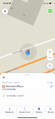
| Sun 31 Jul 2022 in 52,5: 52.1009832, 5.1671697 geohashing.info google osm bing/os kml crox |
Location
Next to the Utrechtseweg in De Bilt.
Participants
Plans
xnyhps
I was planning to make a cycling trip anyway, so when the hash showed up as being on the grass between the road and the adjacent cycling path I decided to go for it. Planned a route from Zeist, via De Bilt to Utrecht which would take me past the hash point.
Expedition
Everything went as planned, although a bit more rainy than the forecast had shown.
Photos
Proof
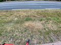
The location of the hash
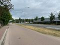
The surroundings of the hash point
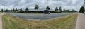
Panorama around the hash point (with an interesting bus driving by)

