Difference between revisions of "2022-08-06 43 7"
(→Location) |
m |
||
| (10 intermediate revisions by 3 users not shown) | |||
| Line 22: | Line 22: | ||
--> | --> | ||
*[[User:Arkel|Arkel]] | *[[User:Arkel|Arkel]] | ||
| − | |||
| − | |||
| − | |||
| − | |||
| − | |||
== Expedition == | == Expedition == | ||
| − | + | Wow, after a few months of checking the hashpoints of my graticule, mainly composed of sea and mountains, I saw one accessible. And it is only 5min walk from home. It will be my first expedition, and it will be easy! | |
| − | + | So I created my account on Friday, and posted my planned expedition at the official meetup time: Saturday 4pm. | |
| − | + | I got a welcome message from [[User:Fippe|Fippe]] on my [[User talk:Arkel|talk page]]. Thanks :-) | |
| − | + | So around 15:50 I started my expedition. I have been there many times, so nothing to do. | |
| − | + | I stopped on the supermarket along the way to buy a lemonade and some Swiss chocolates in the very unlikely case that I meet someone. | |
| − | |||
| − | |||
| − | |||
| − | |||
| − | + | It was hot! A heatwave started more than one month ago. The pétanque fields usually busy on Saturday were empty. | |
| − | |||
| − | |||
| − | + | I arrived at the geohash at 16:02, in the middle of the path. Finally I reached a hashpoint, I am a geohasher! | |
| − | |||
| − | |||
| − | + | It was so hot! This nice sunny path is crowded in winter, but today is was empty, except from a few crazy people cycling during a heatwave. | |
| − | + | I thought at the few people who cycled very fast thought the hashpoint without knowing. You fools! | |
| − | |||
| − | |||
| − | |||
| − | + | I took the "Stupid Grind" picture together with the surroundings. | |
| − | + | I put the poster next to the hash so that people passing by or future archaeologists will know that the Internet was here. | |
| − | + | while doing it, I noticed some litter on the floor, and a bin a few meters away, nice, an easy Geotrash. | |
| − | |||
| − | |||
| − | |||
| − | |||
| − | |||
| − | |||
| − | |||
| − | |||
| + | I drank the lemonade and waited a few minutes to see if someone will come, or just walk by, but no one came, as expected. | ||
| − | + | So around 16:35 I walked back home. I crossed the town hall on the way back. this is a pretentious neoclassical building for a small town. Fun fact, the mayor who decided to build it was not re-elected, and so never used it. | |
| − | |||
| − | |||
| − | |||
| − | |||
| − | |||
| − | |||
| − | |||
| − | + | I was back home a few minutes after. | |
| − | |||
| − | |||
| − | |||
| − | |||
| − | + | == Photos == | |
| + | <!-- Insert pictures between the gallery tags using the following format: | ||
| + | Image:2020-##-## ## ## Alpha.jpg | Witty Comment | ||
| + | --> | ||
| + | <gallery perrow="5"> | ||
| + | Image:2022-08-06 empty petanque field.jpg||Empty pétanque fields because of the heat | ||
| + | Image:2022-08-06 path entrance.jpg|The path entrance | ||
| + | Image:2022-08-06 hashpoint.jpg|The hashpoint | ||
| + | Image:2022-08-06 proof.png|Proof | ||
| + | Image:2022-08-06 geohasher stupid grind.jpg|Stupid grind | ||
| + | Image:2022-08-06 hashpoint west.jpg|Hashpoint west | ||
| + | Image:2022-08-06 hashpoint north.jpg|Hashpoint north | ||
| + | Image:2022-08-06 hashpoint east.jpg|Hashpoint east | ||
| + | Image:2022-08-06 hashpoint south.jpg|Hashpoint south | ||
| + | Image:2022-08-06 poster.jpg|Poster: the Internet was here! | ||
| + | Image:2022-08-06 trash.jpg|Trash on the floor | ||
| + | Image:2022-08-06 geotrash claim.jpg|Geotrash claim | ||
| + | Image:2022-08-06 townhall.jpg|Town hall, on the way back | ||
| + | </gallery> | ||
| − | + | == Achievements == | |
| − | + | {{#vardefine:ribbonwidth|800px}} | |
| − | + | <!-- Add any achievement ribbons you earned below, or remove this section --> | |
| − | |||
| − | <!-- | ||
| − | |||
| − | |||
| − | |||
| − | |||
| − | --> | ||
| − | |||
| − | |||
[[Category:Expeditions]] | [[Category:Expeditions]] | ||
| − | |||
[[Category:Expeditions with photos]] | [[Category:Expeditions with photos]] | ||
| − | |||
| − | |||
| − | |||
| − | |||
| − | |||
[[Category:Coordinates reached]] | [[Category:Coordinates reached]] | ||
| − | + | {{location|FR|06}} | |
| − | |||
| − | |||
| − | |||
| − | |||
| − | |||
| − | |||
| − | |||
| − | |||
| − | |||
| − | |||
| − | |||
| − | |||
| − | |||
| − | |||
| − | |||
| − | |||
| − | |||
Latest revision as of 17:40, 11 August 2022
| Sat 6 Aug 2022 in 43,7: 43.6737517, 7.1933049 geohashing.info google osm bing/os kml crox |
Location
On the path along the river, near the town hall's parking of Saint-Laurent-du-Var. Easy one ;-)
Participants
Expedition
Wow, after a few months of checking the hashpoints of my graticule, mainly composed of sea and mountains, I saw one accessible. And it is only 5min walk from home. It will be my first expedition, and it will be easy!
So I created my account on Friday, and posted my planned expedition at the official meetup time: Saturday 4pm. I got a welcome message from Fippe on my talk page. Thanks :-)
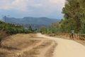
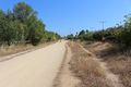
So around 15:50 I started my expedition. I have been there many times, so nothing to do. I stopped on the supermarket along the way to buy a lemonade and some Swiss chocolates in the very unlikely case that I meet someone.
It was hot! A heatwave started more than one month ago. The pétanque fields usually busy on Saturday were empty.
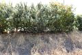
I arrived at the geohash at 16:02, in the middle of the path. Finally I reached a hashpoint, I am a geohasher!
It was so hot! This nice sunny path is crowded in winter, but today is was empty, except from a few crazy people cycling during a heatwave.
I thought at the few people who cycled very fast thought the hashpoint without knowing. You fools!
I took the "Stupid Grind" picture together with the surroundings.
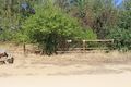
I put the poster next to the hash so that people passing by or future archaeologists will know that the Internet was here. while doing it, I noticed some litter on the floor, and a bin a few meters away, nice, an easy Geotrash.
I drank the lemonade and waited a few minutes to see if someone will come, or just walk by, but no one came, as expected.
So around 16:35 I walked back home. I crossed the town hall on the way back. this is a pretentious neoclassical building for a small town. Fun fact, the mayor who decided to build it was not re-elected, and so never used it.
I was back home a few minutes after.
Photos
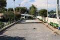
Empty pétanque fields because of the heat
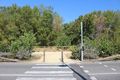
The path entrance
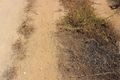
The hashpoint
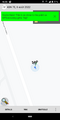
Proof

Stupid grind
Hashpoint west
Hashpoint north
Hashpoint east
Hashpoint south
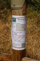
Poster: the Internet was here!
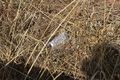
Trash on the floor
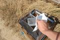
Geotrash claim

Town hall, on the way back


