Difference between revisions of "2022-08-07 53 10"
Leidenfrost (talk | contribs) (2/?3) |
Leidenfrost (talk | contribs) m (→Photos) |
||
| (5 intermediate revisions by the same user not shown) | |||
| Line 14: | Line 14: | ||
Just a lot of riding the bus this time, I had to force the HVV-App to recalculate the route to be more optimal. Actually rather happy that it was this short on a Sunday in the Speckgürtel. I did have to wait for >40 min in ''Wilstedt-Dorfring'', however. | Just a lot of riding the bus this time, I had to force the HVV-App to recalculate the route to be more optimal. Actually rather happy that it was this short on a Sunday in the Speckgürtel. I did have to wait for >40 min in ''Wilstedt-Dorfring'', however. | ||
| − | OSM was of the opinion that the hash lay in a Sand-Quarry so I was initially a bit worried, but the area was desolate and looked rather serene, it was a good thing I heeded the first rule of geohashing and put on long jeans, but I still got stung by a horsefly. There was a pond just a few metres from the hash. | + | OSM was of the opinion that the hash lay in a Sand-Quarry so I was initially a bit worried, but the area was desolate and looked rather serene, it was a good thing I heeded the first rule of geohashing and put on long jeans, but I still got stung by a horsefly. There was a pond just a few metres from the hash. |
| − | + | ==Notes== | |
| + | Only afterwards did I find out that the hash was only 263m from [[2019-12-09 53 10]], incredible, just one field over, and also very close to the road. I vaguely recalled that I've been here before to hash, but I'd have wagered the distance would be >1km. | ||
| + | |||
| + | Just as π π π did before me, I'll issue a ''Tale of Two Hashes''-challenge for ''Tangstedt'' | ||
| + | |||
| + | The second of three consecutive hashes. | ||
==Photos== | ==Photos== | ||
| − | + | <gallery> | |
| + | File:2022-08-07 53 10 HH-SH-border.PNG|crossing into HH shortly | ||
| + | File:2022-08-07 53 10 google.PNG |proof1 | ||
| + | File:2022-08-07 53 10 coord.PNG |proof2 | ||
| + | File:2022-08-07 53 10 road.JPG |the view from the road | ||
| + | File:2022-08-07 53 10 feet.JPG |standing at the hash | ||
| + | File:2022-08-07 53 10 view1.JPG |nice view from the hash to my left | ||
| + | File:2022-08-07 53 10 view2.JPG |nice view from the hash to my right | ||
| + | File:2022-08-07 53 10 pond.JPG |luckily not the hash-pond | ||
| + | </gallery> | ||
==Achievements== | ==Achievements== | ||
| + | {{land geohash | latitude = 53 | longitude = 10 | date = 2022-08-07 }} | ||
{{Public transport geohash | latitude = 53 | longitude = 10 | date = 2022-08-07| busline = 27, S1, 178, 378}} | {{Public transport geohash | latitude = 53 | longitude = 10 | date = 2022-08-07| busline = 27, S1, 178, 378}} | ||
| − | + | {{A Tale of Two Hashes challenge | |
| + | | latitude = 53 | ||
| + | | longitude = 10 | ||
| + | | date = 2022-08-07 | ||
| + | | name = Leidenfrost | ||
| + | | place = Tangstedt | ||
| + | | image = | ||
| + | }} | ||
__NOTOC__ | __NOTOC__ | ||
[[Category:Expeditions]] | [[Category:Expeditions]] | ||
Latest revision as of 14:53, 22 February 2024
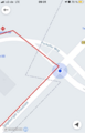
| Sun 7 Aug 2022 in 53,10: 53.7448060, 10.0515324 geohashing.info google osm bing/os kml crox |
Location
By the road in Wilstedt, Tangstedt, Stormarn, Schleswig-Holstein
Participants
Expedition
Got to Farmsen and took the 27 to Wellingsbüttel, took the S1 to Poppenbüttel, then the 178 to Hans-Salb-Straße, Glashütte, then took the 378 to Dorfring, Wilstedt, then walked ~1km to the hash and got back home via Norderstedt-Mitte.
I had plans later in the day, so I set off at 8 to arrive before 12 again.
Just a lot of riding the bus this time, I had to force the HVV-App to recalculate the route to be more optimal. Actually rather happy that it was this short on a Sunday in the Speckgürtel. I did have to wait for >40 min in Wilstedt-Dorfring, however.
OSM was of the opinion that the hash lay in a Sand-Quarry so I was initially a bit worried, but the area was desolate and looked rather serene, it was a good thing I heeded the first rule of geohashing and put on long jeans, but I still got stung by a horsefly. There was a pond just a few metres from the hash.
Notes
Only afterwards did I find out that the hash was only 263m from 2019-12-09 53 10, incredible, just one field over, and also very close to the road. I vaguely recalled that I've been here before to hash, but I'd have wagered the distance would be >1km.
Just as π π π did before me, I'll issue a Tale of Two Hashes-challenge for Tangstedt
The second of three consecutive hashes.
Photos
crossing into HH shortly
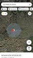
proof1

proof2
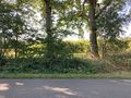
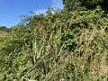
the view from the road
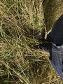
standing at the hash
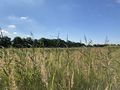
nice view from the hash to my left
nice view from the hash to my right
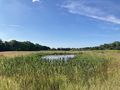
luckily not the hash-pond


Achievements
This user earned the Land geohash achievement
|
This user earned the Public transport geohash achievement
|
