Difference between revisions of "2022-08-19 48 11"
([live picture]Google Maps) |
(expedition report 143/144) |
||
| (3 intermediate revisions by the same user not shown) | |||
| Line 1: | Line 1: | ||
| − | + | {{meetup graticule|lat=48|lon=11|date=2022-08-19}} | |
| − | + | ==Location== | |
| + | on a muddy field in Salmdorf, Haar municipality, Bavaria | ||
| − | + | ==Participants== | |
| − | + | *[[User:π π π|π π π]] ([[User talk:π π π|talk]]) | |
| − | + | ==Expedition== | |
| − | + | I was in Munich for a week to attend the [[wikipedia:2022 European Championships|2022 European Championships]], and this hash was not only reachable, it also fell on a day where I had nothing planned yet for the forenoon (I'd be attending the Men's Mountainbike event in the afternoon and the European Athletics Championships in the evening). | |
| − | |||
| − | |||
| − | |||
| − | |||
| − | |||
| − | |||
| − | |||
| − | |||
| − | |||
| − | |||
| − | |||
| − | |||
| − | |||
| − | |||
| − | + | I set off quite late and rode the U2 to its last stop, Messestadt Ost. From there, I walked 2 km to the hash, between hills, across the suburban but rural-looking town of Salmdorf, and lastly along a well-kept cycling path leading through flat fields. It had rained heavily during the night, and continued to rain lightly during the expedition. OSM said that the hash was at the very edge of a mining area, but recent satellite imagery showed that the area had been converted into fields. Disappointingly (or fortunately?), the satellite images were right: The hash lay 32 m onto a very muddy, recently seeded field (though I could see the mining buildings a bit further back). The seeds were relatively far-spaced, so I could step between the rows and access the hashpoint, where I took some photos with Eagle without Jackie. Fortunately none of the people walking or cycling by called out to me. I considered walking to the edge of the open mine, but didn't want to risk damaging any crops or completely soak my socks on the wet greenery. | |
| − | |||
| − | + | So I scrambled back to the path and tried for a long while with various methods to get as much mud off my shoes as possible, they were absolutely caked. I made my way back to the same station and rode westward, then went to a few places in Munich I had wanted to visit during my trip. Afterward, I had a lot of fun watching the Mountainbike race in the gorgeous Olympic Park and later athletics in the Olympic Stadium of 1972. | |
| − | |||
== Photos == | == Photos == | ||
| − | + | adding pictures using the droid for the first time, might do this regularly | |
| − | |||
| − | |||
<gallery perrow="5"> | <gallery perrow="5"> | ||
| Line 48: | Line 31: | ||
Image:2022-08-19_48_11_π π π_1660903193367.jpg|Google Maps | Image:2022-08-19_48_11_π π π_1660903193367.jpg|Google Maps | ||
| + | |||
| + | Image:2022-08-19_48_11_π π π_1662055536562.jpg|Semi-rural Bavarian cycling path | ||
</gallery> | </gallery> | ||
| − | == Achievements == | + | ==Achievements== |
| − | + | Land geohash, Public transport geohash | |
| − | |||
| − | + | __NOTOC__ | |
| − | + | [[Category:Coordinates reached]] | |
| − | [[Category: | + | [[Category:Land geohash achievement]] |
| − | + | [[Category:Public transport geohash achievement]] | |
| − | |||
| − | |||
| − | |||
| − | |||
| − | [[Category: | ||
| − | |||
| − | |||
| − | |||
| − | |||
| − | |||
[[Category:Expeditions]] | [[Category:Expeditions]] | ||
| − | + | {{location|DE|BY|M}} | |
| − | |||
| − | |||
| − | |||
| − | |||
| − | |||
| − | |||
| − | |||
| − | |||
| − | |||
| − | |||
| − | |||
| − | |||
| − | |||
| − | |||
| − | |||
| − | |||
| − | |||
| − | |||
| − | |||
| − | |||
| − | |||
| − | |||
| − | |||
| − | |||
| − | |||
Latest revision as of 19:02, 10 September 2022
| Fri 19 Aug 2022 in 48,11: 48.1244392, 11.7211850 geohashing.info google osm bing/os kml crox |
Location
on a muddy field in Salmdorf, Haar municipality, Bavaria
Participants
Expedition
I was in Munich for a week to attend the 2022 European Championships, and this hash was not only reachable, it also fell on a day where I had nothing planned yet for the forenoon (I'd be attending the Men's Mountainbike event in the afternoon and the European Athletics Championships in the evening).
I set off quite late and rode the U2 to its last stop, Messestadt Ost. From there, I walked 2 km to the hash, between hills, across the suburban but rural-looking town of Salmdorf, and lastly along a well-kept cycling path leading through flat fields. It had rained heavily during the night, and continued to rain lightly during the expedition. OSM said that the hash was at the very edge of a mining area, but recent satellite imagery showed that the area had been converted into fields. Disappointingly (or fortunately?), the satellite images were right: The hash lay 32 m onto a very muddy, recently seeded field (though I could see the mining buildings a bit further back). The seeds were relatively far-spaced, so I could step between the rows and access the hashpoint, where I took some photos with Eagle without Jackie. Fortunately none of the people walking or cycling by called out to me. I considered walking to the edge of the open mine, but didn't want to risk damaging any crops or completely soak my socks on the wet greenery.
So I scrambled back to the path and tried for a long while with various methods to get as much mud off my shoes as possible, they were absolutely caked. I made my way back to the same station and rode westward, then went to a few places in Munich I had wanted to visit during my trip. Afterward, I had a lot of fun watching the Mountainbike race in the gorgeous Olympic Park and later athletics in the Olympic Stadium of 1972.
Photos
adding pictures using the droid for the first time, might do this regularly

Success! @48.1244,11.7212
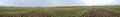
pano
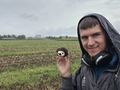
Eagle and π π π

Eagle enjoying the rain at the hash
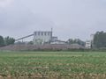
Nearby surface mine
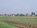
Salmdorf village
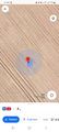
Google Maps
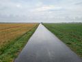
Semi-rural Bavarian cycling path


Achievements
Land geohash, Public transport geohash