Difference between revisions of "2022-08-23 47 -122"
From Geohashing
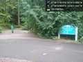
([live picture]Geohasher [https://openstreetmap.org/?mlat=47.57024410&mlon=-122.10656790&zoom=16 @47.5702,-122.1066]) |
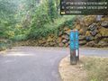
([live picture]Test photo [https://openstreetmap.org/?mlat=47.57030797&mlon=-122.10657397&zoom=16 @47.5703,-122.1066]) |
||
| Line 34: | Line 34: | ||
Image:2022-08-23_47_-122_thomcat_1661301561831.jpg|Geohasher [https://openstreetmap.org/?mlat=47.57024410&mlon=-122.10656790&zoom=16 @47.5702,-122.1066] | Image:2022-08-23_47_-122_thomcat_1661301561831.jpg|Geohasher [https://openstreetmap.org/?mlat=47.57024410&mlon=-122.10656790&zoom=16 @47.5702,-122.1066] | ||
| + | |||
| + | Image:2022-08-23_47_-122_thomcat_1661301615367.jpg|Test photo [https://openstreetmap.org/?mlat=47.57030797&mlon=-122.10657397&zoom=16 @47.5703,-122.1066] | ||
</gallery> | </gallery> | ||
Revision as of 00:40, 24 August 2022
| Tue 23 Aug 2022 in Seattle: 47.5702604, -122.1065778 geohashing.info google osm bing/os kml crox |
Location
Sunrise park trail, between Lake Sammammish and I-90.
Participants
Plans
Stop by after work, then take the bridge back to Seattle.
Expedition
Tracklog
Photos
Trailhead @47.5714,-122.1059
Trail intersection @47.5699,-122.1059

Geohasher @47.5702,-122.1066

Test photo @47.5703,-122.1066


