Difference between revisions of "2022-08-27 51 9"
(Created page with "{{meetup graticule | lat=51 | lon=9 | date=2022-08-27 }} <!-- edit as necessary --> __NOTOC__ == Location == In a forest east of Reichenbach == Participants == User:Digi...") |
(→Expedition) |
||
| Line 22: | Line 22: | ||
Oh man, it has been almost two months without any succesful expedition for me - for different reasons, but mainly, that the hashes were too far away and if they were in my homezone, they would be in the middle of a cornfield or such... So, I got quite excited to see that todays hash seemed to be reachable and not that far away from my home. So, I decided to give it a try! | Oh man, it has been almost two months without any succesful expedition for me - for different reasons, but mainly, that the hashes were too far away and if they were in my homezone, they would be in the middle of a cornfield or such... So, I got quite excited to see that todays hash seemed to be reachable and not that far away from my home. So, I decided to give it a try! | ||
| − | After a 20 minute drive I parked my car along the L 3249 and started to go for the hash from north. Since there seemed to be no real paths leading to the hash, I simply choose the shortest way, which meant to do a small climb after I had passed a huge cornfield and surprisingly I got on a path there, which led me almost directly to the hash. For the final 40 meters I would have needed a chainsaw to cut down all the vegetation, but, I tried to reach the hash by walking in a big circle around the area, and found | + | After a 20 minute drive I parked my car along the L 3249 and started to go for the hash from north. Since there seemed to be no real paths leading to the hash, I simply choose the shortest way, which meant to do a small climb after I had passed a huge cornfield and surprisingly I got on a path there, which led me almost directly to the hash. For the final 40 meters I would have needed a chainsaw to cut down all the vegetation, but, I tried to reach the hash by walking in a big circle around the area, and found some spots that were more or less 'easy' to go... So, after a little while, I got to the hash - this was a little tree in the middle of bushes. Took some pics for proof and then sort of walked the shortest way back to my car, hehe - not following any paths or trails, just following my intuition. |
| − | So... This will become a bad year for geohashing if I remain that unlucky with future hashes! Hope that there will be some good opportunities though, let's just wait and see... | + | So... This will become a bad year for geohashing if I remain that unlucky with future hashes! Hope that there will be some good opportunities soon though, let's just wait and see... |
== Photos == | == Photos == | ||
Latest revision as of 15:35, 27 August 2022
| Sat 27 Aug 2022 in 51,9: 51.1677501, 9.7953851 geohashing.info google osm bing/os kml crox |
Location
In a forest east of Reichenbach
Participants
Plans
Do a little walk to the hash and do some geocaches after that...
Expedition
Oh man, it has been almost two months without any succesful expedition for me - for different reasons, but mainly, that the hashes were too far away and if they were in my homezone, they would be in the middle of a cornfield or such... So, I got quite excited to see that todays hash seemed to be reachable and not that far away from my home. So, I decided to give it a try!
After a 20 minute drive I parked my car along the L 3249 and started to go for the hash from north. Since there seemed to be no real paths leading to the hash, I simply choose the shortest way, which meant to do a small climb after I had passed a huge cornfield and surprisingly I got on a path there, which led me almost directly to the hash. For the final 40 meters I would have needed a chainsaw to cut down all the vegetation, but, I tried to reach the hash by walking in a big circle around the area, and found some spots that were more or less 'easy' to go... So, after a little while, I got to the hash - this was a little tree in the middle of bushes. Took some pics for proof and then sort of walked the shortest way back to my car, hehe - not following any paths or trails, just following my intuition.
So... This will become a bad year for geohashing if I remain that unlucky with future hashes! Hope that there will be some good opportunities soon though, let's just wait and see...
Photos
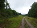
On my way to the hash
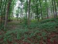
A little climb to the hash
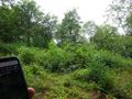
A lot of vegetation on my way
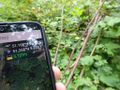
Reached the hash
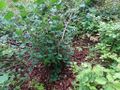
The hash was this tree
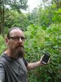
The hasher at the hash location
Proof
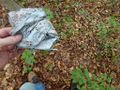
Did collect some trash as well


