Difference between revisions of "2022-11-11 -37 145"
(Location, categories) |
|||
| Line 12: | Line 12: | ||
| date=2022-11-11 | | date=2022-11-11 | ||
}}<!-- edit as necessary --> | }}<!-- edit as necessary --> | ||
| + | |||
| + | ==Location== | ||
| + | This Geohash is located near the confluence of the Plenty and Yarra Rivers. | ||
== Participants == | == Participants == | ||
[[User:Talex|Talex]] ([[User talk:Talex|talk]]) | [[User:Talex|Talex]] ([[User talk:Talex|talk]]) | ||
| − | |||
== Expedition == | == Expedition == | ||
| Line 46: | Line 48: | ||
__NOTOC__ | __NOTOC__ | ||
| − | |||
| − | |||
| − | |||
| − | |||
| − | |||
| − | |||
| − | |||
| − | |||
| − | |||
| − | |||
| − | |||
| − | |||
| − | |||
| − | |||
[[Category:Expeditions]] | [[Category:Expeditions]] | ||
| − | |||
[[Category:Expeditions with photos]] | [[Category:Expeditions with photos]] | ||
| − | |||
| − | |||
| − | |||
| − | |||
| − | |||
[[Category:Coordinates reached]] | [[Category:Coordinates reached]] | ||
| − | |||
| − | |||
| − | |||
| − | |||
| − | |||
| − | |||
| − | |||
| − | |||
| − | |||
| − | |||
| − | |||
| − | |||
| − | |||
| − | |||
| − | |||
| − | |||
| − | |||
| − | |||
Revision as of 20:09, 14 November 2022
| Fri 11 Nov 2022 in -37,145: -37.7510668, 145.1283536 geohashing.info google osm bing/os kml crox |
Location
This Geohash is located near the confluence of the Plenty and Yarra Rivers.
Participants
Expedition
Another morning of waking up and checking the coordinates for the day. Much to my surprise, it's both close to home and I might have the time to make a trip out. Westerfolds park. I feel like I know this park well, but in reality I only know a sliver that I semi-regularly ride my mountain bike through. I flip to the aerial imagery. Next to a creek, looks cliffy. Thanks to the recent Victorian Floods I expect water or mud. Or snakes. Maybe both? My optimism about reaching the coordinates drops, but I plan to make a trip.
The ride out is a beautiful cruise along the riverside bike path. Much simpler than 11 days ago when on a similar route I had to take detours to avoid the floods. I stop for a photo where the Plenty River joins the Yarra, the water level is high but has dropped a couple of meters since list time I was here. Soon it's time to jump off the bike and walk the last 100 meters to the hash. I change into gumboots (hashboots?) and begin to wade through the long grass. There's a path of grass that has been trodden down, probably by kangaroos or wallabies, but it's going straight to the hash. There was no flooding here. Or mud. A bit cliffy though, but I can get close enough to the hash without any risk. Weirdly, there's a small pad of flat grass right to the hash. I take a few pics, return and share my success with our Geohashing chat group.
As I ride home I think about that pad in the grass. It was probably just the local marsupials. But it went to the hash... Maybe there's another Melbourne geohasher. That would be exciting. The only other explanation is that the local wildlife have started geohashing. I guess it's plausible that a roo would steal a newspaper with the DJIA. But compute an MD5 hashsum? No marsupial is anywhere near capable of that! But could a cockatoo? I decide that further research (geohashing) is required...
Photos
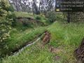
Geohash success! @-37.7510,145.1285

Plenty river 11 days ago.
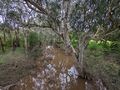
Plenty river today.
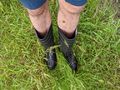
Hash boots
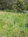
Flattened grass towards the hash
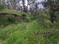
The hash
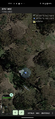
GPS Proof


