Difference between revisions of "2022-12-03 62 29"
(Created page with "{{subst:expedition}}") |
|||
| Line 1: | Line 1: | ||
| − | + | {{meetup graticule | |
| − | |||
| − | |||
| − | |||
| − | |||
| − | |||
| − | |||
| − | |||
| − | |||
| lat={{#explode:{{SUBPAGENAME}}| |1}} | | lat={{#explode:{{SUBPAGENAME}}| |1}} | ||
| lon={{#explode:{{SUBPAGENAME}}| |2}} | | lon={{#explode:{{SUBPAGENAME}}| |2}} | ||
| date={{#explode:{{SUBPAGENAME}}| |0}} | | date={{#explode:{{SUBPAGENAME}}| |0}} | ||
| − | }} | + | }} |
== Location == | == Location == | ||
| − | + | In a forest near highway 74. | |
| + | |||
| + | The point on a topographic map: {{MapSiteLink | lat = 62.6003317 | lon = 29.8920806 | title = Geohash+2022-12-03+62+29}} | ||
== Participants == | == Participants == | ||
| − | + | * [[User:Kripakko|Kripakko]] | |
| − | + | * Kripakko's girlfriend | |
| − | |||
| − | |||
| − | |||
== Expedition == | == Expedition == | ||
| − | + | This was a nice point that would be well accessible with a little cycling and walking despite the wintry conditions. | |
| + | I stayed at my girlfriend's place, and I did not have the GPS receiver with me, so I downloaded Geohash Droid and gave it a go. | ||
| + | We cycled through the city to highway 74 and stopped near the hashpoint. | ||
| + | I walked the last 90 metres to visit the point while my girlfriend waited at the roadside. | ||
| + | Nothing really interesting happened at any point. | ||
| − | + | I did not have GPS tracking on, but using the map I estimated that I had cycled about 19.9 kilometres and walked about 190 metres. | |
| − | + | I also did not have a thermometer, but the weather forecasts I looked at showed a temperature of −5 °C which felt more like −10 °C with wind. | |
| + | That it pretty much how I felt too. | ||
| + | I will have a look at this day's weather statistics tomorrow when they are published. | ||
== Photos == | == Photos == | ||
| − | < | + | <gallery perrow="6"> |
| − | + | 2022-12-03_62_29_01-pielisjoki.jpg | The Pielisjoki river. | |
| − | -- | + | 2022-12-03_62_29_02-iiksenjoki.jpg | The Iiksenjoki river. |
| − | + | 2022-12-03_62_29_03-highway.jpg | Highway 74 where I parked the bicycle, about 90 metres to go. | |
| + | 2022-12-03_62_29_04-selfie.jpg | Selfie at the hashpoint. | ||
| + | 2022-12-03_62_29_05-screenshot1.png | Proof of location #1 | ||
| + | 2022-12-03_62_29_06-screenshot2.png | Proof of location #2 | ||
</gallery> | </gallery> | ||
== Achievements == | == Achievements == | ||
{{#vardefine:ribbonwidth|100%}} | {{#vardefine:ribbonwidth|100%}} | ||
| − | + | ||
| + | {{land geohash | ||
| + | | name = [[User:Kripakko|Kripakko]] | ||
| + | | latitude = 62 | ||
| + | | longitude = 29 | ||
| + | | date = 2022-12-03 | ||
| + | }} | ||
| + | {{bicycle geohash | ||
| + | | name = [[User:Kripakko|Kripakko]] | ||
| + | | latitude = 62 | ||
| + | | longitude = 29 | ||
| + | | date = 2022-12-03 | ||
| + | | bothways = true | ||
| + | | distance = 19.9 km | ||
| + | }} | ||
| + | {{Frozen Geohash | ||
| + | | name = [[User:Kripakko|Kripakko]] | ||
| + | | latitude = 62 | ||
| + | | longitude = 29 | ||
| + | | date = 2022-12-03 | ||
| + | | temperature = −5 °C | ||
| + | }} | ||
__NOTOC__ | __NOTOC__ | ||
| − | |||
| − | |||
| − | |||
| − | |||
| − | |||
| − | |||
| − | |||
| − | |||
| − | |||
| − | |||
| − | |||
| − | |||
| − | |||
| − | |||
[[Category:Expeditions]] | [[Category:Expeditions]] | ||
| − | |||
[[Category:Expeditions with photos]] | [[Category:Expeditions with photos]] | ||
| − | |||
| − | |||
| − | |||
| − | |||
| − | |||
[[Category:Coordinates reached]] | [[Category:Coordinates reached]] | ||
| − | |||
| − | |||
| − | |||
| − | |||
| − | |||
| − | |||
| − | |||
| − | |||
| − | |||
| − | |||
| − | |||
| − | |||
| − | |||
| − | |||
| − | |||
| − | |||
| − | |||
| − | |||
Revision as of 13:37, 3 December 2022
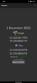
| Sat 3 Dec 2022 in 62,29: 62.6003317, 29.8920806 geohashing.info google osm bing/os kml crox |
Location
In a forest near highway 74.
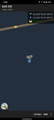
The point on a topographic map: [1]
Participants
- Kripakko
- Kripakko's girlfriend
Expedition
This was a nice point that would be well accessible with a little cycling and walking despite the wintry conditions. I stayed at my girlfriend's place, and I did not have the GPS receiver with me, so I downloaded Geohash Droid and gave it a go. We cycled through the city to highway 74 and stopped near the hashpoint. I walked the last 90 metres to visit the point while my girlfriend waited at the roadside. Nothing really interesting happened at any point.
I did not have GPS tracking on, but using the map I estimated that I had cycled about 19.9 kilometres and walked about 190 metres. I also did not have a thermometer, but the weather forecasts I looked at showed a temperature of −5 °C which felt more like −10 °C with wind. That it pretty much how I felt too. I will have a look at this day's weather statistics tomorrow when they are published.
Photos
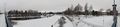
The Pielisjoki river.
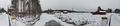
The Iiksenjoki river.
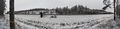
Highway 74 where I parked the bicycle, about 90 metres to go.
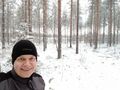
Selfie at the hashpoint.
Proof of location #1
Proof of location #2


Achievements
Kripakko earned the Land geohash achievement
|
Kripakko earned the Bicycle geohash achievement
|
