Difference between revisions of "2022-12-03 62 29"
| Line 22: | Line 22: | ||
I did not have GPS tracking on, but using the map I estimated that I had cycled about 19.9 kilometres and walked about 190 metres. | I did not have GPS tracking on, but using the map I estimated that I had cycled about 19.9 kilometres and walked about 190 metres. | ||
I also did not have a thermometer, but the weather forecasts I looked at showed a temperature of −5 °C which felt more like −10 °C with wind. | I also did not have a thermometer, but the weather forecasts I looked at showed a temperature of −5 °C which felt more like −10 °C with wind. | ||
| − | That | + | That is pretty much how I felt too. |
| − | I will have a look at this day's weather statistics tomorrow when they are published. | + | <!-- I will have a look at this day's weather statistics tomorrow when they are published. --> |
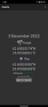
| + | Afterwards, [https://en.ilmatieteenlaitos.fi/observations-in-finland?station=101632 Finnish Meteorological Institute] reported a temperature of −5.7 °C in Joensuu at 13:00, | ||
| + | and [https://www.accuweather.com/en/fi/joensuu/133941/december-weather/133941?year=2022 AccuWeather.com] reported a high temperature of −5 °C for the day. | ||
| + | Therefore, I am going to call it −5 °C. | ||
== Photos == | == Photos == | ||
| − | <gallery perrow=" | + | <gallery perrow="7"> |
2022-12-03_62_29_01-pielisjoki.jpg | The Pielisjoki river. | 2022-12-03_62_29_01-pielisjoki.jpg | The Pielisjoki river. | ||
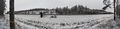
2022-12-03_62_29_02-iiksenjoki.jpg | The Iiksenjoki river. | 2022-12-03_62_29_02-iiksenjoki.jpg | The Iiksenjoki river. | ||
| Line 33: | Line 36: | ||
2022-12-03_62_29_05-screenshot1.png | Proof of location #1 | 2022-12-03_62_29_05-screenshot1.png | Proof of location #1 | ||
2022-12-03_62_29_06-screenshot2.png | Proof of location #2 | 2022-12-03_62_29_06-screenshot2.png | Proof of location #2 | ||
| + | 2022-12-03_62_29_07-temperature.png | Screenshot of Finnish Meteorological Institute's observation history. The data will apparently disappear in a few days, so I captured this for permanent proof. | ||
</gallery> | </gallery> | ||
Latest revision as of 08:48, 5 December 2022
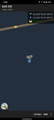
| Sat 3 Dec 2022 in 62,29: 62.6003317, 29.8920806 geohashing.info google osm bing/os kml crox |
Location
In a forest near highway 74.
The point on a topographic map: [1]
Participants
- Kripakko
- Kripakko's girlfriend
Expedition
This was a nice point that would be well accessible with a little cycling and walking despite the wintry conditions. I stayed at my girlfriend's place, and I did not have the GPS receiver with me, so I downloaded Geohash Droid and gave it a go. We cycled through the city to highway 74 and stopped near the hashpoint. I walked the last 90 metres to visit the point while my girlfriend waited at the roadside. Nothing really interesting happened at any point. There was only some five centimetres of snow at most, so it did not cause any troubles either.
I did not have GPS tracking on, but using the map I estimated that I had cycled about 19.9 kilometres and walked about 190 metres. I also did not have a thermometer, but the weather forecasts I looked at showed a temperature of −5 °C which felt more like −10 °C with wind. That is pretty much how I felt too. Afterwards, Finnish Meteorological Institute reported a temperature of −5.7 °C in Joensuu at 13:00, and AccuWeather.com reported a high temperature of −5 °C for the day. Therefore, I am going to call it −5 °C.
Photos
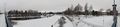
The Pielisjoki river.
The Iiksenjoki river.
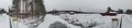
Highway 74 where I parked the bicycle, about 90 metres to go.
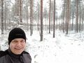
Selfie at the hashpoint.
Proof of location #1
Proof of location #2
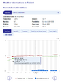
Screenshot of Finnish Meteorological Institute's observation history. The data will apparently disappear in a few days, so I captured this for permanent proof.


Achievements
Kripakko earned the Land geohash achievement
|
Kripakko earned the Bicycle geohash achievement
|
