Difference between revisions of "2022-12-07 52 4"
FelixTheCat (talk | contribs) (Created page with "{{subst:Expedition |lat = 52 |lon = 4 |date = 2022-12-07 }}") |
FelixTheCat (talk | contribs) |
||
| Line 1: | Line 1: | ||
| − | + | {{meetup graticule | |
| − | |||
| − | |||
| − | |||
| − | |||
| − | |||
| − | |||
| − | |||
| − | |||
| lat=52 | | lat=52 | ||
| lon=4 | | lon=4 | ||
| date=2022-12-07 | | date=2022-12-07 | ||
| − | }} | + | }} |
== Location == | == Location == | ||
| − | + | On the edge of Nootdorp, South Holland province. | |
== Participants == | == Participants == | ||
| − | + | [[User:FelixTheCat|FelixTheCat]] ([[User talk:FelixTheCat|talk]]) | |
| − | |||
| − | |||
| − | |||
| − | |||
== Expedition == | == Expedition == | ||
| − | + | Today's hash was pretty close to home, so a good candidate for a bicycle geohash. These days it gets dark at around 16:30, so going after work was not really an option. I decided to get up a bit earlier than usual and ride to the point before work. Since Kat was cycling to Ypenburg train station we decided to ride together. The weather was ok, a bit cold and grey but it didn't rain (at least not a significant amount). At the train station our ways parted and I rode on towards the hash. It turned out to be in a marshy area right next to the train tracks and the A12 motorway. I parked the bike and walked along a muddy path towards the point. Unfortunately, it was located in the middle of a reed bed and therefore impossible to reach. I took photos for documentation and then rode back towards Delft and to the office. | |
| − | |||
| − | |||
| − | |||
== Photos == | == Photos == | ||
| − | |||
| − | |||
| − | |||
<gallery perrow="5"> | <gallery perrow="5"> | ||
| + | Image:2022-12-07 52 4 FelixTheCat 1.JPG | Parked the bike at the beginning of the path. | ||
| + | Image:2022-12-07 52 4 FelixTheCat 2.JPG | It's all kind of muddy, not great when wearing non-waterproof shoes. | ||
| + | Image:2022-12-07 52 4 FelixTheCat 3.JPG | The point is somewhere in front here. Walking there is really not an option: even if you don't mind flattening all that vegetation, it's likely you'll suddenly find the ground disappearing below your feet, since reed beds typically occur in swampy areas. | ||
| + | Image:2022-12-07 52 4 FelixTheCat 4.png | Missed the point by more than 20 metres. | ||
| + | Image:2022-12-07 52 4 FelixTheCat 5.JPG | Lloyd is disappointed. | ||
</gallery> | </gallery> | ||
== Achievements == | == Achievements == | ||
{{#vardefine:ribbonwidth|100%}} | {{#vardefine:ribbonwidth|100%}} | ||
| − | + | {{There might be alligators! | |
| + | | latitude = 52 | ||
| + | | longitude = 4 | ||
| + | | date = 2022-12-07 | ||
| + | | name = [[User:FelixTheCat|FelixTheCat]] ([[User talk:FelixTheCat|talk]]) | ||
| + | | hazard = reed bed | ||
| + | }} | ||
__NOTOC__ | __NOTOC__ | ||
| − | |||
| − | |||
| − | |||
| − | |||
| − | |||
| − | |||
| − | |||
| − | |||
| − | |||
| − | |||
| − | |||
| − | |||
| − | |||
| − | |||
[[Category:Expeditions]] | [[Category:Expeditions]] | ||
| − | |||
[[Category:Expeditions with photos]] | [[Category:Expeditions with photos]] | ||
| − | |||
| − | |||
| − | |||
| − | |||
| − | |||
| − | |||
| − | |||
| − | |||
| − | |||
[[Category:Coordinates not reached]] | [[Category:Coordinates not reached]] | ||
| − | |||
| − | |||
[[Category:Not reached - Mother Nature]] | [[Category:Not reached - Mother Nature]] | ||
| − | |||
| − | |||
| − | |||
| − | |||
| − | |||
| − | |||
| − | |||
| − | |||
| − | |||
| − | |||
| − | |||
Revision as of 07:00, 12 December 2022
| Wed 7 Dec 2022 in 52,4: 52.0501523, 4.4330437 geohashing.info google osm bing/os kml crox |
Location
On the edge of Nootdorp, South Holland province.
Participants
Expedition
Today's hash was pretty close to home, so a good candidate for a bicycle geohash. These days it gets dark at around 16:30, so going after work was not really an option. I decided to get up a bit earlier than usual and ride to the point before work. Since Kat was cycling to Ypenburg train station we decided to ride together. The weather was ok, a bit cold and grey but it didn't rain (at least not a significant amount). At the train station our ways parted and I rode on towards the hash. It turned out to be in a marshy area right next to the train tracks and the A12 motorway. I parked the bike and walked along a muddy path towards the point. Unfortunately, it was located in the middle of a reed bed and therefore impossible to reach. I took photos for documentation and then rode back towards Delft and to the office.
Photos
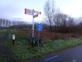
Parked the bike at the beginning of the path.
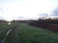
It's all kind of muddy, not great when wearing non-waterproof shoes.
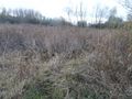
The point is somewhere in front here. Walking there is really not an option: even if you don't mind flattening all that vegetation, it's likely you'll suddenly find the ground disappearing below your feet, since reed beds typically occur in swampy areas.
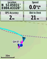
Missed the point by more than 20 metres.
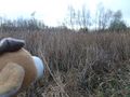
Lloyd is disappointed.


Achievements
FelixTheCat (talk) earned the There might be alligators! consolation prize
|