2022-12-19 1 103
| Mon 19 Dec 2022 in 1,103: 1.2933038, 103.8839559 geohashing.info google osm bing/os kml crox |
Location
Wooded area south-west of the ECP/Fort Road interchange, bounded by ECP and a cycle bridge to the north and Marina East Drive to the east and south.
Participants
Plans
Expedition
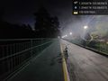
Took a bus to bus stop 90069 Opp Dunman High Sch, and used bike sharing from the bus stop.
I originally wanted to cycle to the pavement along Marina East Drive on the side closest to the location, then getting as close as possible, but the lack of proper crossings to that side of the road and lots of heavy vehicle movement to the worksite nearby meant a change of plan!
Instead, I cycled onto the park connector and bridge from East Coast Park to Gardens By The Bay Bay East, and stopped at the closest point on the bridge about 150m from the geohash.
Got a few pictures and coordinates, then continued cycling along the path (which was way longer than expected!) past the desalination plant, ending at Water Venture where I got a bus out.
Tracklog
Photos
First geohash! @1.2946,103.8843
