Difference between revisions of "2023-01-03 -41 173"
(write it) |
|||
| Line 1: | Line 1: | ||
| + | [[File:PXL_20230102_234128670.jpg|thumb|200px|left|Success!]] | ||
| + | |||
{{meetup graticule | {{meetup graticule | ||
| lat=-41 | | lat=-41 | ||
| Line 4: | Line 6: | ||
| date=2023-01-03 | | date=2023-01-03 | ||
}}<!-- edit as necessary --> | }}<!-- edit as necessary --> | ||
| + | |||
| + | <div style="clear:left" /> | ||
== Location == | == Location == | ||
On the side of a hill near St Arnaud. | On the side of a hill near St Arnaud. | ||
| Line 13: | Line 17: | ||
=== Prologue === | === Prologue === | ||
| + | <gallery perrow="5"> | ||
| + | File:PXL_20230102_225453382.jpg|We seek an easier way in | ||
| + | </gallery> | ||
Travelling around New Zealand for a month in a rental car, I was itching to sink my teeth into a geohash. There were factors working in my favour: no fixed plans, a car, the flexibility to travel further than I normally would, and the low population of New Zealand meaning very low chance of a hash being in or next to a house. But factors against too, notably the mountainous terrain and few roads. Already I'd seen a few that were close but impossible: the wrong side of a steep ridge, or just miles from the nearest road. | Travelling around New Zealand for a month in a rental car, I was itching to sink my teeth into a geohash. There were factors working in my favour: no fixed plans, a car, the flexibility to travel further than I normally would, and the low population of New Zealand meaning very low chance of a hash being in or next to a house. But factors against too, notably the mountainous terrain and few roads. Already I'd seen a few that were close but impossible: the wrong side of a steep ridge, or just miles from the nearest road. | ||
| Line 20: | Line 27: | ||
=== Going on === | === Going on === | ||
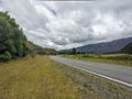
| + | [[File:PXL_20230103_002201718.jpg|thumb|400px|This was the much easier way in]] | ||
| + | |||
Immediately, an enormous obstacle. Instead of the hill reasonably and considerately connecting with the road at a pleasingly gentle angle, it forms a cliff, overgrown with heinous vegetation. It looks savage. Let's call that one...Plan B. | Immediately, an enormous obstacle. Instead of the hill reasonably and considerately connecting with the road at a pleasingly gentle angle, it forms a cliff, overgrown with heinous vegetation. It looks savage. Let's call that one...Plan B. | ||
| Line 32: | Line 41: | ||
Tiring of the bramble dodging, and overheating despite the overcast day, I hop the fence and praise the cool shade of the pine trees. It's peaceful, but somehow feels even steeper. It aches to walk straight up the hill, so I make my own switchbacks, crossing the odd fallen branch. | Tiring of the bramble dodging, and overheating despite the overcast day, I hop the fence and praise the cool shade of the pine trees. It's peaceful, but somehow feels even steeper. It aches to walk straight up the hill, so I make my own switchbacks, crossing the odd fallen branch. | ||
| − | Before too long, I home in on the point. It looks like every other part of this plantation: pine trees above, pine needles below. | + | Before too long, I home in on the point. It looks like every other part of this plantation: pine trees above, pine needles below. 300m of climbing to get here. |
=== Getting out === | === Getting out === | ||
| Line 45: | Line 54: | ||
== Photos == | == Photos == | ||
<gallery perrow="5"> | <gallery perrow="5"> | ||
| − | |||
| − | |||
File:PXL_20230102_225826469.jpg|That's a giant ''cordyline australis'' or "New Zealand cabbage tree" growing by the creek | File:PXL_20230102_225826469.jpg|That's a giant ''cordyline australis'' or "New Zealand cabbage tree" growing by the creek | ||
File:PXL_20230102_230046672.jpg|Giant debris heap | File:PXL_20230102_230046672.jpg|Giant debris heap | ||
| Line 52: | Line 59: | ||
File:PXL_20230102_231535579.jpg|From paddock to pines | File:PXL_20230102_231535579.jpg|From paddock to pines | ||
File:PXL_20230102_232008486.jpg|Very steep in the pine forest | File:PXL_20230102_232008486.jpg|Very steep in the pine forest | ||
| − | |||
File:PXL_20230102_235137388.jpg|View from the top | File:PXL_20230102_235137388.jpg|View from the top | ||
</gallery> | </gallery> | ||
| Line 61: | Line 67: | ||
__NOTOC__ | __NOTOC__ | ||
| − | |||
| − | |||
| − | |||
| − | |||
| − | |||
| − | |||
| − | |||
| − | |||
| − | |||
| − | |||
| − | |||
| − | |||
| − | |||
| − | |||
[[Category:Expeditions]] | [[Category:Expeditions]] | ||
| − | |||
| − | |||
| − | |||
| − | |||
| − | |||
| − | |||
| − | |||
[[Category:Coordinates reached]] | [[Category:Coordinates reached]] | ||
| − | |||
| − | |||
| − | |||
| − | |||
| − | |||
| − | |||
| − | |||
| − | |||
| − | |||
| − | |||
| − | |||
| − | |||
| − | |||
| − | |||
| − | |||
| − | |||
| − | |||
| − | |||
Revision as of 23:45, 28 January 2023

| Tue 3 Jan 2023 in -41,173: -41.7241734, 173.1040821 geohashing.info google osm bing/os kml crox |
Location
On the side of a hill near St Arnaud.
Participants
Expedition
Prologue
We seek an easier way in

Travelling around New Zealand for a month in a rental car, I was itching to sink my teeth into a geohash. There were factors working in my favour: no fixed plans, a car, the flexibility to travel further than I normally would, and the low population of New Zealand meaning very low chance of a hash being in or next to a house. But factors against too, notably the mountainous terrain and few roads. Already I'd seen a few that were close but impossible: the wrong side of a steep ridge, or just miles from the nearest road.
This one looked like a definite chance. Only a few km down the road from where we were camped in St Arnaud. The hill would be steep, but the point looked to be in a pine plantation, which meant I wouldn't be bothering anyone by going in. And just a few hundred metres from the road.
Having learnt the value of properly equipping oneself, I brought gaiters, a backpack, water. I parked along the highway and sauntered in.
Going on

Immediately, an enormous obstacle. Instead of the hill reasonably and considerately connecting with the road at a pleasingly gentle angle, it forms a cliff, overgrown with heinous vegetation. It looks savage. Let's call that one...Plan B.
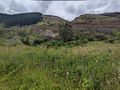
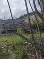
I saunter further, ignoring the whoosh of campervans, trucks and little rental cars that frequent this highway. I'm now close to a building -- a house? -- but see a way through. I'll just have to navigate a small field of lupins, a barbed wire fence, a creek, a gigantic pile of logging debris, and a steep 4WD track to get to the hill I want to climb. Doable!
These obstacles yielding without complaint (even the creek was just leapable), I stride up the track, to the fence line.
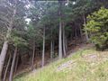
A choice: right of the fence is a paddock, seemingly populated with a sparse herd of sheep, and more than a few brambles. Perhaps following the sheep trails will be easier walking, but within view of whoever's property this is. Or cross into the pine plantation, where the dirt and pine needles look slippery and slow. I start right.
It's steep. Like, really steep. Like, try to find rocks and tussocks as steps to avoid sliding on the slick, dry grass. Try to avoid grabbing handfuls of brambles. Remember to drink. Climb. Upwards.
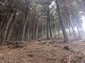
Tiring of the bramble dodging, and overheating despite the overcast day, I hop the fence and praise the cool shade of the pine trees. It's peaceful, but somehow feels even steeper. It aches to walk straight up the hill, so I make my own switchbacks, crossing the odd fallen branch.
Before too long, I home in on the point. It looks like every other part of this plantation: pine trees above, pine needles below. 300m of climbing to get here.
Getting out
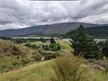
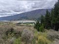
Having climbed so high, I sidle across the hill to get a view of the valley. Then stomp as fast as I can manage down. Down. Down. I admire the foxgloves. I pay respect to the "wild Irishman", a native New Zealand shrub with fearsome thorns, and scowl at the blackberries that cross my path.
At the bottom of the track, I once more ponder why the creators of this track blocked it so comprehensively with a huge pile of tree stumps and other debris, but reach no firm conclusions. I find a better way across the creek and back over the fence, scurrying delightedly to my underpowered but fuel-efficient vehicle, and skedaddle out of there.
Tracklog

Photos
That's a giant cordyline australis or "New Zealand cabbage tree" growing by the creek
Giant debris heap
A rare moment of flattish ground
From paddock to pines
Very steep in the pine forest
View from the top


