Difference between revisions of "2023-01-03 48 2"
AmeliaThe1st (talk | contribs) (Created page with "{{subst:Expedition |lat = 48 |lon = 2 |date = 2023-01-03 }}") |
AmeliaThe1st (talk | contribs) (Did the report. Hope I didn't make too many mistakes.) |
||
| Line 13: | Line 13: | ||
}}<!-- edit as necessary --> | }}<!-- edit as necessary --> | ||
== Location == | == Location == | ||
| − | + | In the Port-Royal forest, in the Yvelines. | |
== Participants == | == Participants == | ||
| − | + | [[User:AmeliaThe1st|AmeliaThe1st]] ([[User talk:AmeliaThe1st|talk]]), and a friend from my university I kidnapped (with consent). | |
--> | --> | ||
== Plans == | == Plans == | ||
| − | + | So, the plan was to leave our university after our exam, the take the RER (public transport train) line B up to Saint-Rémy-Les-Chevreuse or Courcelle-Sur-Yvette, then either take the bus up to the forest or go there on foot, eat there, then come back through either the bus or on foot, then to go back home with the RER line B. | |
== Expedition == | == Expedition == | ||
| − | + | So, we finished our exams at 11, then bought some food to eat once there, then we took the metro, reached the RER line B, then took it all the way to Courcelle-Sur-Yvette (it took about an hour, I think). | |
| − | + | Then, we walked up to the geohash. It was kinda hard to reach it exactly, because it was off the track through spiky bushes. But, we got there eventually. | |
| − | + | Took a picture and a few more to get a proof (didn't get a good proof, but it's "readable"). | |
| − | + | We got back on the path, and sat and ate on a log nearby. | |
| + | Then we went back on foot down to Saint-Rémy-Les-Chevreuse, took the RER and went home | ||
== Photos == | == Photos == | ||
| − | |||
| − | |||
| − | |||
<gallery perrow="5"> | <gallery perrow="5"> | ||
| + | Image:2023-01-03 48 2 Map small.png | The walking part of the trip, start at "Départ", end at "Arrivée". | ||
| + | Image:2023-01-03 48 2 Stupid grin with friend no proof.JPG | At the hash. The stupid grin is me. | ||
| + | Image:2023-01-03 48 2 Geohash tree trunk.JPG | The tree trunk at the exact point of the hashpoint. | ||
| + | Image:2023-01-03 48 2 Coordinates proof.JPG | The proof for us being there at the hashpoint exactly. Readable if you squint very hard. (red is hashpoint, blue is us) | ||
</gallery> | </gallery> | ||
| + | <!-- | ||
| + | Not sure exactly how this works. So, I'm leaving it commented out for now. | ||
== Achievements == | == Achievements == | ||
{{#vardefine:ribbonwidth|100%}} | {{#vardefine:ribbonwidth|100%}} | ||
| − | + | Add any achievement ribbons you earned below, or remove this section | |
| + | --> | ||
__NOTOC__ | __NOTOC__ | ||
<!-- =============== USEFUL CATEGORIES FOLLOW ================ | <!-- =============== USEFUL CATEGORIES FOLLOW ================ | ||
Delete the next line ONLY if you have chosen the appropriate categories below. If you are unsure, don't worry. People will read your report and help you with the classification. --> | Delete the next line ONLY if you have chosen the appropriate categories below. If you are unsure, don't worry. People will read your report and help you with the classification. --> | ||
| − | |||
<!-- ==REQUEST FOR TWITTER BOT== Please leave either the New report or the Expedition planning category in as long as you work on it. This helps the twitter bot a lot with announcing the right outcome at the right moment. --> | <!-- ==REQUEST FOR TWITTER BOT== Please leave either the New report or the Expedition planning category in as long as you work on it. This helps the twitter bot a lot with announcing the right outcome at the right moment. --> | ||
| Line 53: | Line 57: | ||
<!-- If all those plans are never acted upon, change [[Category:Expedition planning]] to [[Category:Not reached - Did not attempt]]. --> | <!-- If all those plans are never acted upon, change [[Category:Expedition planning]] to [[Category:Not reached - Did not attempt]]. --> | ||
| + | [[Category:Expeditions]] | ||
| + | [[Category:Expeditions with photos]] | ||
<!-- An actual expedition: | <!-- An actual expedition: | ||
| − | |||
-- and one or more of -- | -- and one or more of -- | ||
| − | |||
[[Category:Expeditions with videos]] | [[Category:Expeditions with videos]] | ||
[[Category:Expedition without GPS]] | [[Category:Expedition without GPS]] | ||
--> | --> | ||
| + | [[Category:Coordinates reached]] | ||
<!-- if you reached your coords: | <!-- if you reached your coords: | ||
| − | |||
Revision as of 19:31, 3 January 2023
| Tue 3 Jan 2023 in 48,2: 48.7241734, 2.1040821 geohashing.info google osm bing/os kml crox |
Location
In the Port-Royal forest, in the Yvelines.
Participants
AmeliaThe1st (talk), and a friend from my university I kidnapped (with consent). -->
Plans
So, the plan was to leave our university after our exam, the take the RER (public transport train) line B up to Saint-Rémy-Les-Chevreuse or Courcelle-Sur-Yvette, then either take the bus up to the forest or go there on foot, eat there, then come back through either the bus or on foot, then to go back home with the RER line B.
Expedition
So, we finished our exams at 11, then bought some food to eat once there, then we took the metro, reached the RER line B, then took it all the way to Courcelle-Sur-Yvette (it took about an hour, I think). Then, we walked up to the geohash. It was kinda hard to reach it exactly, because it was off the track through spiky bushes. But, we got there eventually. Took a picture and a few more to get a proof (didn't get a good proof, but it's "readable"). We got back on the path, and sat and ate on a log nearby. Then we went back on foot down to Saint-Rémy-Les-Chevreuse, took the RER and went home
Photos
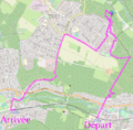
The walking part of the trip, start at "Départ", end at "Arrivée".
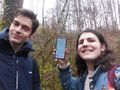
At the hash. The stupid grin is me.
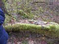
The tree trunk at the exact point of the hashpoint.
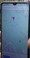
The proof for us being there at the hashpoint exactly. Readable if you squint very hard. (red is hashpoint, blue is us)


