Difference between revisions of "2023-01-05 62 29"
(Created page with "{{subst:expedition}}") |
|||
| Line 1: | Line 1: | ||
| − | + | {{meetup graticule | |
| − | |||
| − | |||
| − | |||
| − | |||
| − | |||
| − | |||
| − | |||
| − | |||
| lat={{#explode:{{SUBPAGENAME}}| |1}} | | lat={{#explode:{{SUBPAGENAME}}| |1}} | ||
| lon={{#explode:{{SUBPAGENAME}}| |2}} | | lon={{#explode:{{SUBPAGENAME}}| |2}} | ||
| date={{#explode:{{SUBPAGENAME}}| |0}} | | date={{#explode:{{SUBPAGENAME}}| |0}} | ||
| − | }} | + | }} |
== Location == | == Location == | ||
| − | + | In a piece of frozen marshland in Marjala, Joensuu. | |
| + | |||
| + | The point on a topographic map: {{MapSiteLink | lat = 62.6262091 | lon = 29.6600487 | title = Geohash+2023-01-05+62+29}} | ||
== Participants == | == Participants == | ||
| − | + | * [[User:Kripakko|Kripakko]] | |
| − | + | ||
| + | == Expedition == | ||
| + | The hashpoint was located in a former bay of the lake (the name "Matalalahti" is literally "Shallow Bay") that is nowadays some wet marshland. | ||
| + | There are even some tiny ponds drawn on the topographic map, and the point is in one of them. | ||
| + | In the summer, one might need to wade, but in January everything is frozen, so I would probably be all right. | ||
| + | Snow would potentially cause trouble if there was much of it, but I was confident that I could traverse a hundred metres even in deep snow. | ||
| + | |||
| + | I started cycling through the city towards Marjala. | ||
| + | The last time I looked at a weather forecast, it was supposed to be around −12 °C and sunny, but it turned out to be −7 °C and snowing. | ||
| + | At times I had to cycle into heavy gusts of headwind and snowfall which thankfully calmed down after a while. | ||
| + | It was also icy and very slippery, but my studded tyres took care of that very well. | ||
| − | + | I arrived at the former bay and parked the bicycle. | |
| − | + | I had to walk a hundred metres in snow which was mostly about 30 cm deep and up to 50 cm in some places. | |
| + | A little went inside my boots, but that was no problem. | ||
| + | At the hashpoint, I checked whether there was ice or ground under the snow by kicking it away. | ||
| + | I dug up several pieces of floral matter, saw the frozen ground and noticed the distinct smell of marshland, | ||
| + | so this turned out to be a land geohash. | ||
| + | I have no doubt that it would be seriously wet in the summer though. | ||
| − | + | I cycled back to the city, visited a few places in the centrum and went back home. | |
| − | + | According to the GPS receiver, the length of the trip was 22.2 km, | |
| + | of which I cycled 21.9 km and walked 0.3 km. | ||
== Tracklog == | == Tracklog == | ||
| − | + | {{tracklog | 2023-01-05 62 29 tracklog.gpx}} | |
== Photos == | == Photos == | ||
| − | |||
| − | |||
| − | |||
<gallery perrow="5"> | <gallery perrow="5"> | ||
| + | Image:2022-01-05_62_29_01-highway.jpg | Highway 9 near Siilainen. | ||
| + | Image:2022-01-05_62_29_02-höytiäinencanal.jpg | The canal of Höytiäinen. | ||
| + | Image:2022-01-05_62_29_03-marjalacanal.jpg | The canal of Marjala. | ||
| + | Image:2022-01-05_62_29_04-salpaline.jpg | Houses in the Marjala suburb and boulders of the [https://en.wikipedia.org/wiki/Salpa_Line Salpa Line]. | ||
| + | Image:2022-01-05_62_29_05-bicycle.jpg | Where I parked the bicycle, about 100 metres to go. | ||
| + | Image:2022-01-05_62_29_06-gpsr1.jpg | Proof of location. | ||
| + | Image:2022-01-05_62_29_07-gpsr2.jpg | Proof of date and time. | ||
| + | Image:2022-01-05_62_29_08-stupidgrin.jpg | Stupid Grin™ | ||
| + | Image:2022-01-05_62_29_09-thermometer.jpg | Proof of temperature. | ||
| + | Image:2022-01-05_62_29_10-hashpoint.jpg | How the hashpoint and the surroundings look like. | ||
</gallery> | </gallery> | ||
== Achievements == | == Achievements == | ||
{{#vardefine:ribbonwidth|100%}} | {{#vardefine:ribbonwidth|100%}} | ||
| − | + | ||
| + | {{land geohash | ||
| + | | name = [[User:Kripakko|Kripakko]] | ||
| + | | latitude = 62 | ||
| + | | longitude = 29 | ||
| + | | date = 2023-01-05 | ||
| + | }} | ||
| + | {{bicycle geohash | ||
| + | | name = [[User:Kripakko|Kripakko]] | ||
| + | | latitude = 62 | ||
| + | | longitude = 29 | ||
| + | | date = 2023-01-05 | ||
| + | | bothways = true | ||
| + | | distance = 21.9 km | ||
| + | }} | ||
| + | {{Frozen Geohash | ||
| + | | name = [[User:Kripakko|Kripakko]] | ||
| + | | latitude = 62 | ||
| + | | longitude = 29 | ||
| + | | date = 2023-01-05 | ||
| + | | temperature = −7 °C | ||
| + | }} | ||
__NOTOC__ | __NOTOC__ | ||
| − | |||
| − | |||
| − | |||
| − | |||
| − | |||
| − | |||
| − | |||
| − | |||
| − | |||
| − | |||
| − | |||
| − | |||
| − | |||
[[Category:Expeditions]] | [[Category:Expeditions]] | ||
| − | |||
[[Category:Expeditions with photos]] | [[Category:Expeditions with photos]] | ||
| − | |||
| − | |||
| − | |||
| − | |||
| − | |||
[[Category:Coordinates reached]] | [[Category:Coordinates reached]] | ||
| − | |||
| − | |||
| − | |||
| − | |||
| − | |||
| − | |||
| − | |||
| − | |||
| − | |||
| − | |||
| − | |||
| − | |||
| − | |||
| − | |||
| − | |||
| − | |||
| − | |||
| − | |||
Revision as of 21:27, 5 January 2023
| Thu 5 Jan 2023 in 62,29: 62.6262091, 29.6600487 geohashing.info google osm bing/os kml crox |
Location
In a piece of frozen marshland in Marjala, Joensuu.
The point on a topographic map: [1]
Participants
Expedition
The hashpoint was located in a former bay of the lake (the name "Matalalahti" is literally "Shallow Bay") that is nowadays some wet marshland. There are even some tiny ponds drawn on the topographic map, and the point is in one of them. In the summer, one might need to wade, but in January everything is frozen, so I would probably be all right. Snow would potentially cause trouble if there was much of it, but I was confident that I could traverse a hundred metres even in deep snow.
I started cycling through the city towards Marjala. The last time I looked at a weather forecast, it was supposed to be around −12 °C and sunny, but it turned out to be −7 °C and snowing. At times I had to cycle into heavy gusts of headwind and snowfall which thankfully calmed down after a while. It was also icy and very slippery, but my studded tyres took care of that very well.
I arrived at the former bay and parked the bicycle. I had to walk a hundred metres in snow which was mostly about 30 cm deep and up to 50 cm in some places. A little went inside my boots, but that was no problem. At the hashpoint, I checked whether there was ice or ground under the snow by kicking it away. I dug up several pieces of floral matter, saw the frozen ground and noticed the distinct smell of marshland, so this turned out to be a land geohash. I have no doubt that it would be seriously wet in the summer though.
I cycled back to the city, visited a few places in the centrum and went back home. According to the GPS receiver, the length of the trip was 22.2 km, of which I cycled 21.9 km and walked 0.3 km.
Tracklog
Photos
Highway 9 near Siilainen.
The canal of Höytiäinen.
The canal of Marjala.
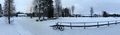
Houses in the Marjala suburb and boulders of the Salpa Line.
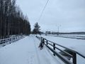
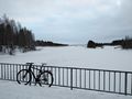
Where I parked the bicycle, about 100 metres to go.
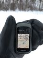
Proof of location.
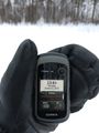
Proof of date and time.
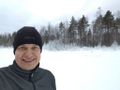
Stupid Grin™
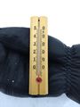
Proof of temperature.
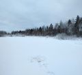
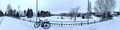
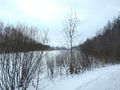
How the hashpoint and the surroundings look like.


Achievements
Kripakko earned the Land geohash achievement
|
Kripakko earned the Bicycle geohash achievement
|
