Difference between revisions of "2023-01-11 -43 171"
From Geohashing
Felix Dance (talk | contribs) (Added photos) |
m (→Photos: gallery fix) |
||
| Line 23: | Line 23: | ||
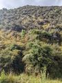
File:Geohash 2023-01-11 -43 171 02 View.jpg | File:Geohash 2023-01-11 -43 171 02 View.jpg | ||
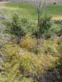
File:Geohash 2023-01-11 -43 171 05 Valley.jpg | File:Geohash 2023-01-11 -43 171 05 Valley.jpg | ||
| − | |||
| − | |||
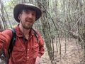
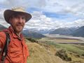
Image:2023-01-11_-43_171_stevage_1673452044974.jpg|Success! (Photo 20m from hash) | Image:2023-01-11_-43_171_stevage_1673452044974.jpg|Success! (Photo 20m from hash) | ||
</gallery> | </gallery> | ||
Revision as of 23:13, 11 January 2023

| Wed 11 Jan 2023 in -43,171: -43.0388145, 171.6755386 geohashing.info google osm bing/os kml crox |
Location
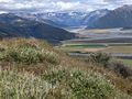
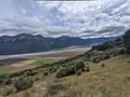
800m south of the road near Arthur's Pass, South Island, New Zealand.
Participants
Expedition
Stevage scrub-bashed his way across 800m horizontal and 300m of vertical to reach the spectacular views from this hash. More to come.
Photos
Success! (Photo 20m from hash)


