Difference between revisions of "2023-01-19 1 103"
From Geohashing
DangerAspect (talk | contribs) ([live picture]This haspoint comes with a celebratory tunnel of lights! [https://openstreetmap.org/?mlat=1.29710920&mlon=103.84679550&zoom=16 @1.2971,103.8468]) |
DangerAspect (talk | contribs) |
||
| Line 14: | Line 14: | ||
== Location == | == Location == | ||
<!-- where you've surveyed the hash to be --> | <!-- where you've surveyed the hash to be --> | ||
| + | Grassy slope near Dhoby Ghaut/Fort Canning Park, between Canning Rise and Canning Walk. | ||
== Participants == | == Participants == | ||
<!-- who attended: If you link to your wiki user name in this section, your expedition will be picked up by the various statistics generated for geohashing. You may use three tildes ~ as a shortcut to automatically insert the user signature of the account you are editing with. | <!-- who attended: If you link to your wiki user name in this section, your expedition will be picked up by the various statistics generated for geohashing. You may use three tildes ~ as a shortcut to automatically insert the user signature of the account you are editing with. | ||
--> | --> | ||
| − | + | * [[User:DangerAspect|DangerAspect]] ([[User talk:DangerAspect|talk]]) | |
| − | |||
| − | |||
== Expedition == | == Expedition == | ||
<!-- how it all turned out. your narrative goes here. --> | <!-- how it all turned out. your narrative goes here. --> | ||
| − | + | Surprisingly accessible! Got a notification for a nearby Geohash, went to Dhoby Ghaut via public transport, and walked the rest of the way. | |
| − | |||
| − | |||
== Photos == | == Photos == | ||
| Line 48: | Line 45: | ||
<!-- ==REQUEST FOR TWITTER BOT== Please leave either the New report or the Expedition planning category in as long as you work on it. This helps the twitter bot a lot with announcing the right outcome at the right moment. --> | <!-- ==REQUEST FOR TWITTER BOT== Please leave either the New report or the Expedition planning category in as long as you work on it. This helps the twitter bot a lot with announcing the right outcome at the right moment. --> | ||
| − | |||
| − | |||
| − | |||
| − | |||
| − | |||
| − | |||
| − | |||
| − | |||
[[Category:Expeditions]] | [[Category:Expeditions]] | ||
| − | |||
[[Category:Expeditions with photos]] | [[Category:Expeditions with photos]] | ||
| − | |||
| − | |||
| − | |||
| − | |||
| − | |||
[[Category:Coordinates reached]] | [[Category:Coordinates reached]] | ||
| − | |||
| − | |||
| − | |||
| − | |||
| − | |||
| − | |||
| − | |||
| − | |||
| − | |||
| − | |||
| − | |||
| − | |||
| − | |||
| − | |||
| − | |||
| − | |||
| − | |||
| − | |||
Revision as of 17:11, 28 January 2023
| Thu 19 Jan 2023 in 1,103: 1.2971337, 103.8467990 geohashing.info google osm bing/os kml crox |
Location
Grassy slope near Dhoby Ghaut/Fort Canning Park, between Canning Rise and Canning Walk.
Participants
Expedition
Surprisingly accessible! Got a notification for a nearby Geohash, went to Dhoby Ghaut via public transport, and walked the rest of the way.
Photos
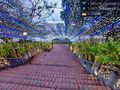
This haspoint comes with a celebratory tunnel of lights! @1.2971,103.8468
