Difference between revisions of "2023-01-19 1 103"
From Geohashing
DangerAspect (talk | contribs) |
m (looks finished, removing Category:New report) |
||
| Line 41: | Line 41: | ||
__NOTOC__ | __NOTOC__ | ||
| − | |||
| − | |||
| − | |||
| − | |||
| − | |||
| − | |||
[[Category:Expeditions]] | [[Category:Expeditions]] | ||
[[Category:Expeditions with photos]] | [[Category:Expeditions with photos]] | ||
[[Category:Coordinates reached]] | [[Category:Coordinates reached]] | ||
Revision as of 19:04, 28 January 2023
| Thu 19 Jan 2023 in 1,103: 1.2971337, 103.8467990 geohashing.info google osm bing/os kml crox |
Location
Grassy slope near Dhoby Ghaut/Fort Canning Park, between Canning Rise and Canning Walk.
Participants
Expedition
Surprisingly accessible! Got a notification for a nearby Geohash, went to Dhoby Ghaut via public transport, and walked the rest of the way.
Photos
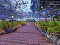
This haspoint comes with a celebratory tunnel of lights! @1.2971,103.8468

Achievements
DangerAspect earned the Land geohash achievement
|
DangerAspect earned the Public transport geohash achievement
|