Difference between revisions of "2023-01-21 48 2"
m (Location) |
AmeliaThe1st (talk | contribs) (Filled out report.) |
||
| Line 15: | Line 15: | ||
<!-- where you've surveyed the hash to be --> | <!-- where you've surveyed the hash to be --> | ||
So, the hash is between Vincennes and Fontenay-Sous-Bois. Should be fairly easy to get to for anyone in Paris. | So, the hash is between Vincennes and Fontenay-Sous-Bois. Should be fairly easy to get to for anyone in Paris. | ||
| + | |||
| + | -- After going there -- | ||
| + | |||
| + | It was in a restricted area: too close to the train tracks. | ||
== Participants == | == Participants == | ||
| Line 20: | Line 24: | ||
--> | --> | ||
Hopefully I can get the other Paris geohashers to come, even though they don't seem to be active anymore. Will send a message their way. I'll bring board games. | Hopefully I can get the other Paris geohashers to come, even though they don't seem to be active anymore. Will send a message their way. I'll bring board games. | ||
| + | |||
| + | -- After going there -- | ||
| + | |||
| + | No one showed up (that I saw), except for me ([[User:AmeliaThe1st|AmeliaThe1st]] ([[User talk:AmeliaThe1st|talk]])) and my dad. | ||
== Plans == | == Plans == | ||
| Line 27: | Line 35: | ||
== Expedition == | == Expedition == | ||
<!-- how it all turned out. your narrative goes here. --> | <!-- how it all turned out. your narrative goes here. --> | ||
| + | Got out of my climbing class. My dad arrived (I gave him a meeting to my class, so we could go together). Got myself a cookie and we were off. We walked for about 3.5 kilometers, and we got there. | ||
| + | |||
| + | Sadly, though, the hashpoint was inside the restricted RATP (paris public transport) area, because it was too close to the traintracks. We tried to find someone to let us in, but we found no-one working there. So we went home, and snagged the coordinates from the train. Still too far, though. | ||
| − | + | Still got a grin photo in the train home, 'cause, it was fun. Still dissapointed though. | |
| − | |||
== Photos == | == Photos == | ||
<!-- Insert pictures between the gallery tags using the following format: | <!-- Insert pictures between the gallery tags using the following format: | ||
| − | |||
--> | --> | ||
<gallery perrow="5"> | <gallery perrow="5"> | ||
| + | Image:2023-01-21 48 2 grin.jpg | Me and my dad. I'm doing the stupid grin. | ||
| + | Image:2023-01-21 proof (not quite).jpg | The coordinates from the street. Too far (~5 meters). | ||
| + | Image:2023-01-21 48 2 proof (not quite) 2, electric boogaloo.jpg | The coordinates from the train. Still too far. | ||
</gallery> | </gallery> | ||
| + | <!-- | ||
== Achievements == | == Achievements == | ||
{{#vardefine:ribbonwidth|100%}} | {{#vardefine:ribbonwidth|100%}} | ||
| + | --> | ||
<!-- Add any achievement ribbons you earned below, or remove this section --> | <!-- Add any achievement ribbons you earned below, or remove this section --> | ||
| Line 50: | Line 64: | ||
<!-- Potential categories. Please include all the ones appropriate to your expedition --> | <!-- Potential categories. Please include all the ones appropriate to your expedition --> | ||
<!-- If this is a planning page: | <!-- If this is a planning page: | ||
| + | [[Category:Expedition planning]] | ||
--> | --> | ||
| − | |||
<!-- If all those plans are never acted upon, change [[Category:Expedition planning]] to [[Category:Not reached - Did not attempt]]. --> | <!-- If all those plans are never acted upon, change [[Category:Expedition planning]] to [[Category:Not reached - Did not attempt]]. --> | ||
| + | [[Category:Expeditions]] | ||
| + | [[Category:Expeditions with photos]] | ||
<!-- An actual expedition: | <!-- An actual expedition: | ||
| − | |||
-- and one or more of -- | -- and one or more of -- | ||
| − | |||
[[Category:Expeditions with videos]] | [[Category:Expeditions with videos]] | ||
[[Category:Expedition without GPS]] | [[Category:Expedition without GPS]] | ||
| Line 67: | Line 81: | ||
| − | --> | + | --> |
[[Category:Coordinates not reached]] | [[Category:Coordinates not reached]] | ||
| + | [[Category:Not reached - No public access]] | ||
| + | <!-- or if you failed :( | ||
-- and a reason -- | -- and a reason -- | ||
When there is a natural obstacle between you and the target: | When there is a natural obstacle between you and the target: | ||
| Line 74: | Line 90: | ||
When there is a man-made obstacle between you and the target: | When there is a man-made obstacle between you and the target: | ||
| − | |||
When you failed get your GPS, car, bike or such to work: | When you failed get your GPS, car, bike or such to work: | ||
Latest revision as of 23:36, 21 January 2023
| Sat 21 Jan 2023 in 48,2: 48.8451459, 2.4587795 geohashing.info google osm bing/os kml crox |
Location
So, the hash is between Vincennes and Fontenay-Sous-Bois. Should be fairly easy to get to for anyone in Paris.
-- After going there --
It was in a restricted area: too close to the train tracks.
Participants
Hopefully I can get the other Paris geohashers to come, even though they don't seem to be active anymore. Will send a message their way. I'll bring board games.
-- After going there --
No one showed up (that I saw), except for me (AmeliaThe1st (talk)) and my dad.
Plans
I'll try to reach it after my climbing class. (Should have time: it ends at 14:45, meaning I've got 1h15 to get to the meeting).
Expedition
Got out of my climbing class. My dad arrived (I gave him a meeting to my class, so we could go together). Got myself a cookie and we were off. We walked for about 3.5 kilometers, and we got there.
Sadly, though, the hashpoint was inside the restricted RATP (paris public transport) area, because it was too close to the traintracks. We tried to find someone to let us in, but we found no-one working there. So we went home, and snagged the coordinates from the train. Still too far, though.
Still got a grin photo in the train home, 'cause, it was fun. Still dissapointed though.
Photos
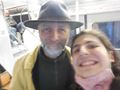
Me and my dad. I'm doing the stupid grin.
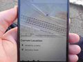
The coordinates from the street. Too far (~5 meters).
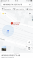
The coordinates from the train. Still too far.

.jpg)
_2,_electric_boogaloo.jpg)