Difference between revisions of "2023-01-28 34 -118"
From Geohashing
(An expedition message sent via Geohash Droid for Android.) |
m (→Location) |
||
| (6 intermediate revisions by 3 users not shown) | |||
| Line 14: | Line 14: | ||
== Location == | == Location == | ||
<!-- where you've surveyed the hash to be --> | <!-- where you've surveyed the hash to be --> | ||
| + | Next to the intersection of Seco St and Rosemont Ave in Pasadena. | ||
== Participants == | == Participants == | ||
<!-- who attended: If you link to your wiki user name in this section, your expedition will be picked up by the various statistics generated for geohashing. You may use three tildes ~ as a shortcut to automatically insert the user signature of the account you are editing with. | <!-- who attended: If you link to your wiki user name in this section, your expedition will be picked up by the various statistics generated for geohashing. You may use three tildes ~ as a shortcut to automatically insert the user signature of the account you are editing with. | ||
--> | --> | ||
| + | *[[User:Boppy5|Boppy5]] | ||
| + | *[[User:Bravissimo594|Bravissimo594]] | ||
== Plans == | == Plans == | ||
| Line 25: | Line 28: | ||
<!-- how it all turned out. your narrative goes here. --> | <!-- how it all turned out. your narrative goes here. --> | ||
| + | |||
| + | *Planning to check on the accessibility of this spot at 4:10 pm local time. -- [[User:Bravissimo594|Bravissimo594]] ([[User talk:Bravissimo594|talk]]) 16:07, 28 January 2023 (PST) | ||
== Tracklog == | == Tracklog == | ||
<!-- if your GPS device keeps a log, you may use Template:Tracklog, post a link here, or both --> | <!-- if your GPS device keeps a log, you may use Template:Tracklog, post a link here, or both --> | ||
| Line 33: | Line 38: | ||
--> | --> | ||
<gallery perrow="5"> | <gallery perrow="5"> | ||
| + | |||
| + | Image:2023-01-28_34_-118_Bravissimo594_1674951318627.jpg|Success! [https://openstreetmap.org/?mlat=34.15721389&mlon=-118.16386389&zoom=16 @34.1572,-118.1639] | ||
| + | |||
| + | Image:2023-01-28_34_-118_Bravissimo594_1674951374414.jpg|Left a poster [https://openstreetmap.org/?mlat=34.15721389&mlon=-118.16386389&zoom=16 @34.1572,-118.1639] | ||
| + | |||
| + | Image:2023-01-28_34_-118_Bravissimo594_1674951450954.jpg|Rose Bowl stadium visible across the recreation fields from the spot [https://openstreetmap.org/?mlat=34.15721389&mlon=-118.16386389&zoom=16 @34.1572,-118.1639] | ||
</gallery> | </gallery> | ||
| Line 40: | Line 51: | ||
__NOTOC__ | __NOTOC__ | ||
| − | |||
| − | |||
| − | |||
| − | |||
| − | |||
| − | |||
| − | |||
| − | |||
| − | |||
| − | |||
| − | |||
| − | |||
| − | |||
| − | |||
[[Category:Expeditions]] | [[Category:Expeditions]] | ||
| − | |||
[[Category:Expeditions with photos]] | [[Category:Expeditions with photos]] | ||
| − | |||
| − | |||
| − | |||
| − | |||
| − | |||
[[Category:Coordinates reached]] | [[Category:Coordinates reached]] | ||
| − | + | {{location|US|CA|LO}} | |
| − | |||
| − | |||
| − | |||
| − | |||
| − | |||
| − | |||
| − | |||
| − | |||
| − | |||
| − | |||
| − | |||
| − | |||
| − | |||
| − | |||
| − | |||
| − | |||
| − | |||
Latest revision as of 23:49, 14 October 2023
| Sat 28 Jan 2023 in 34,-118: 34.1572106, -118.1638864 geohashing.info google osm bing/os kml crox |
Location
Next to the intersection of Seco St and Rosemont Ave in Pasadena.
Participants
Plans
Expedition
- Planning to check on the accessibility of this spot at 4:10 pm local time. -- Bravissimo594 (talk) 16:07, 28 January 2023 (PST)
Tracklog
Photos
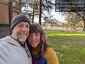
Success! @34.1572,-118.1639
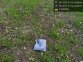
Left a poster @34.1572,-118.1639
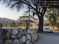
Rose Bowl stadium visible across the recreation fields from the spot @34.1572,-118.1639


