Difference between revisions of "2023-02-02 51 13"
(→Location) |
m (linkfix, catfix) |
||
| (5 intermediate revisions by 2 users not shown) | |||
| Line 17: | Line 17: | ||
== Participants == | == Participants == | ||
| − | + | [[User:Oisín|Oisín]] ([[User talk:Oisín|talk]]) | |
| − | |||
== Plans == | == Plans == | ||
| − | + | If the weather is not too wet, [[User:Oisín|Oisín]] plans to cycle to the hash after work. | |
== Expedition == | == Expedition == | ||
| − | + | ||
| + | === Oisín === | ||
| + | As some rain had passed in the afternoon I decided to cycle to the hash point. I planned a route beforehand in order to combine this trip with the collection of [https://squadrats.com/ Squadrats]. In online maps the world is divided into tiles and this is another GPS-based activity where one tries to visit as many tiles as possible. | ||
| + | |||
| + | I reached the hash without any problems. The footpath was very muddy but still possible to use. The area was well accessible with not too much vegetation. After taking a picture I continued the path and cycled to the market to get some fresh fruit and vegetables. On my way home the next rain came along and I arrived fully soaked :-(. But at the end I had reached my first hash for quite a long time and visited 50 new map tiles. | ||
== Tracklog == | == Tracklog == | ||
| Line 30: | Line 33: | ||
== Photos == | == Photos == | ||
| − | < | + | <gallery> |
| − | + | Image:2023-02-02_51_13_Oisín_1675365029938.jpg|stupid grin at the hash point | |
| − | |||
| − | |||
| − | |||
| − | Image:2023-02-02_51_13_Oisín_1675365029938.jpg| | ||
</gallery> | </gallery> | ||
| Line 43: | Line 42: | ||
__NOTOC__ | __NOTOC__ | ||
| − | <!-- =============== USEFUL CATEGORIES FOLLOW ================ | + | <!-- =============== USEFUL CATEGORIES FOLLOW ================ --> |
| − | |||
| − | |||
| − | |||
| − | |||
| − | |||
| − | |||
| − | |||
| − | |||
| − | |||
| − | |||
| − | |||
| − | |||
[[Category:Expeditions]] | [[Category:Expeditions]] | ||
| − | |||
[[Category:Expeditions with photos]] | [[Category:Expeditions with photos]] | ||
| − | |||
| − | |||
| − | |||
| − | |||
[[Category:Coordinates reached]] | [[Category:Coordinates reached]] | ||
| − | + | {{location|DE|SN|DD}} | |
| − | |||
| − | |||
| − | |||
| − | |||
| − | |||
| − | |||
| − | |||
| − | |||
| − | |||
| − | |||
| − | |||
| − | |||
| − | |||
| − | |||
| − | |||
| − | |||
| − | |||
Latest revision as of 12:26, 3 February 2023
| Thu 2 Feb 2023 in 51,13: 51.0128577, 13.8339021 geohashing.info google osm bing/os kml crox |
Location
The hash is located in a bushy foresty area in the southeast of Dresden. Access should be possible from the southeast using a footpath over a larger meadow.
Participants
Plans
If the weather is not too wet, Oisín plans to cycle to the hash after work.
Expedition
Oisín
As some rain had passed in the afternoon I decided to cycle to the hash point. I planned a route beforehand in order to combine this trip with the collection of Squadrats. In online maps the world is divided into tiles and this is another GPS-based activity where one tries to visit as many tiles as possible.
I reached the hash without any problems. The footpath was very muddy but still possible to use. The area was well accessible with not too much vegetation. After taking a picture I continued the path and cycled to the market to get some fresh fruit and vegetables. On my way home the next rain came along and I arrived fully soaked :-(. But at the end I had reached my first hash for quite a long time and visited 50 new map tiles.
Tracklog
Photos
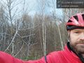
stupid grin at the hash point
