Difference between revisions of "2023-02-12 47 11"
Gefrierbrand (talk | contribs) ([live picture]radome from afar) |
Gefrierbrand (talk | contribs) m |
||
| (11 intermediate revisions by 2 users not shown) | |||
| Line 1: | Line 1: | ||
| − | + | {{meetup graticule | |
| − | |||
| − | |||
| − | |||
| − | |||
| − | |||
| − | |||
| − | |||
| − | |||
| lat=47 | | lat=47 | ||
| lon=11 | | lon=11 | ||
| date=2023-02-12 | | date=2023-02-12 | ||
| − | }} | + | }} |
== Location == | == Location == | ||
| − | + | On a meadow near Raisting south of the Ammersee | |
== Participants == | == Participants == | ||
| − | + | * [[User:Santu|Santu]] | |
| − | + | * [[User:Gefrierbrand|Gefierbrand]] | |
| − | == | + | == Expedition == |
| − | + | This time, the geohashing algorithm led to a point somewhat close to the [https://www.erdfunkstelle-radom.de/ Erdfunkstelle Raisting] where several large an even more smaller satellite-dishes and a 50 m-diameter Radome are located. It was also close to the Ammersee and a very beautiful sunny day, so the ideal opportunity to go on an adventure. | |
| − | + | We drove along nice sunlit roads towards Raisting and had to stop to take a picture as soon as we spotted the radome in the distance. We then continued towards the village and parked there. Continuing on foot, we first ventured towards the hashpoint which was "guarded" by quite a few horses. Luckily the hashlocation was outside of any pastures and was easy to reach. (Besides the small creek which Gefrierbrand jumped over and Santu circumvented by walking a slightly longer path towards the next bridge.) | |
| − | + | ||
| + | After taking the obligatory pictures we continued strolling around through the village and headed for the large field with all the antennas. Despite the cold temperatures the sun was already really strong and we often changed between wearing our coats and carrying them. Unfortunately, we couldn't enter the radome, so perhaps we'll have to visit again sometime else. | ||
| + | |||
| + | Lastly we used the opportunity and also headed to the Ammersee and ate tasty cake near it's shore before returning home again. | ||
== Tracklog == | == Tracklog == | ||
| − | + | {{tracklog | T2023-02-12-14-36 gh Raisting.gpx}} | |
== Photos == | == Photos == | ||
| − | + | ||
| − | |||
| − | |||
<gallery perrow="5"> | <gallery perrow="5"> | ||
| − | + | Image:2023-02-12_47_11_Gefrierbrand_1676217812707.jpg|Radome visible from afar | |
| − | Image:2023-02- | + | Image:2023-02-12_47_11_Gefrierbrand_1676217869482.jpg|StupidGrin<sup>TM</sup> |
| − | + | Image:2023-02-12_47_11_Gefrierbrand_1676217903558.jpg|Lots of antennas | |
| − | Image:2023-02- | + | Image:2023-02-12_47_11_Gefrierbrand_1676218019440.jpg|Santu infront of dish |
| + | Image:2023-02-12_47_11_Gefrierbrand_1676218046388.jpg|Gefrierbrand in front of dish | ||
| + | Image:2023-02-12_47_11_Gefrierbrand_1676217920132.jpg|Us with radome up close | ||
| + | Image:2023-02-12_47_11_Gefrierbrand_1676217827754.jpg|Ammersee | ||
| + | Image:2023-02-12_47_11_Gefrierbrand_1676217523431.jpg|Proof | ||
</gallery> | </gallery> | ||
== Achievements == | == Achievements == | ||
| − | {{ | + | {{gratuitous ribbon |
| − | + | | color = white | |
| + | | icon = antennadishes.png | ||
| + | | latitude = 47 | ||
| + | | longitude = 11 | ||
| + | | date = 2023-02-12 | ||
| + | | achievement = Radio Uplink Achievement | ||
| + | | description = reaching a geohash somewhat close to very large antennas | ||
| + | | name = Gefrierbrand & Santu | ||
| + | }} | ||
__NOTOC__ | __NOTOC__ | ||
| − | |||
| − | |||
| − | |||
| − | |||
| − | |||
| − | |||
| − | |||
| − | |||
| − | |||
| − | |||
| − | |||
| − | |||
| − | |||
[[Category:Expeditions]] | [[Category:Expeditions]] | ||
| − | |||
[[Category:Expeditions with photos]] | [[Category:Expeditions with photos]] | ||
| − | |||
| − | |||
| − | |||
| − | |||
| − | |||
[[Category:Coordinates reached]] | [[Category:Coordinates reached]] | ||
| − | + | {{location|DE|BY|WM}} | |
| − | |||
| − | |||
| − | |||
| − | |||
| − | |||
| − | |||
| − | |||
| − | |||
| − | |||
| − | |||
| − | |||
| − | |||
| − | |||
| − | |||
| − | |||
| − | |||
| − | |||
Latest revision as of 19:12, 12 February 2023
| Sun 12 Feb 2023 in 47,11: 47.9197193, 11.1288074 geohashing.info google osm bing/os kml crox |
Location
On a meadow near Raisting south of the Ammersee
Participants
Expedition
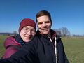
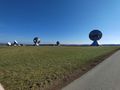
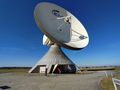
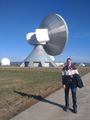
This time, the geohashing algorithm led to a point somewhat close to the Erdfunkstelle Raisting where several large an even more smaller satellite-dishes and a 50 m-diameter Radome are located. It was also close to the Ammersee and a very beautiful sunny day, so the ideal opportunity to go on an adventure.
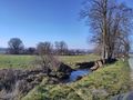
We drove along nice sunlit roads towards Raisting and had to stop to take a picture as soon as we spotted the radome in the distance. We then continued towards the village and parked there. Continuing on foot, we first ventured towards the hashpoint which was "guarded" by quite a few horses. Luckily the hashlocation was outside of any pastures and was easy to reach. (Besides the small creek which Gefrierbrand jumped over and Santu circumvented by walking a slightly longer path towards the next bridge.)
After taking the obligatory pictures we continued strolling around through the village and headed for the large field with all the antennas. Despite the cold temperatures the sun was already really strong and we often changed between wearing our coats and carrying them. Unfortunately, we couldn't enter the radome, so perhaps we'll have to visit again sometime else.
Lastly we used the opportunity and also headed to the Ammersee and ate tasty cake near it's shore before returning home again.
Tracklog
Photos
Radome visible from afar
StupidGrinTM
Lots of antennas
Santu infront of dish
Gefrierbrand in front of dish
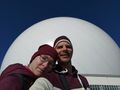
Us with radome up close
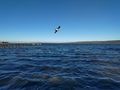
Ammersee
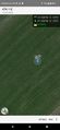
Proof


Achievements
Gefrierbrand & Santu earned the Radio Uplink Achievement
|