Difference between revisions of "2023-02-18 -37 144"
From Geohashing
([live picture]Made it) |
|||
| (8 intermediate revisions by 4 users not shown) | |||
| Line 13: | Line 13: | ||
}}<!-- edit as necessary --> | }}<!-- edit as necessary --> | ||
== Location == | == Location == | ||
| − | + | In a Macca's carpark in Broadmeadows. | |
== Participants == | == Participants == | ||
| − | + | ||
| − | + | Expedition 1: | |
| + | |||
| + | * [[User:Johnwrw|Johnwrw]] | ||
| + | |||
| + | Expedition 2: | ||
| + | |||
| + | * [[User:Stevage|Stevage]] | ||
== Plans == | == Plans == | ||
<!-- what were the original plans --> | <!-- what were the original plans --> | ||
| − | == Expedition == | + | == Expedition 1== |
<!-- how it all turned out. your narrative goes here. --> | <!-- how it all turned out. your narrative goes here. --> | ||
| + | |||
| + | == Expedition 2 (Stevage) == | ||
| + | |||
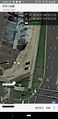
| + | [[File:PXL_20230218_040852525.jpg|400px]] | ||
| + | |||
| + | A couple of days early, my doctor had given me permission to ride a bike again after surgery. Time to go for it! I cycled up the Merri Creek Trail, to the hallowed land of McDonalds Corporation. I was briefly thrown by the fact that a red car was in a different spot than in the aerial imagery, but it didn't stop me achieving my goal. Then I had a chocolate thickshake and some French fries. | ||
| + | |||
| + | On the way back, I found myself following a bike path that had been an old train line, and thus discovered a rail trail I didn't know about. | ||
== Tracklog == | == Tracklog == | ||
| Line 43: | Line 57: | ||
== Achievements == | == Achievements == | ||
{{#vardefine:ribbonwidth|100%}} | {{#vardefine:ribbonwidth|100%}} | ||
| + | {{bicycle geohash | ||
| + | | latitude={{#explode:{{SUBPAGENAME}}| |1}} | ||
| + | | longitude={{#explode:{{SUBPAGENAME}}| |2}} | ||
| + | | date={{#explode:{{SUBPAGENAME}}| |0}} | ||
| + | | name=John and Steve | ||
| + | | distance= | ||
| + | | bothways= | ||
| + | }} | ||
<!-- Add any achievement ribbons you earned below, or remove this section --> | <!-- Add any achievement ribbons you earned below, or remove this section --> | ||
__NOTOC__ | __NOTOC__ | ||
| − | |||
| − | |||
| − | |||
| − | |||
| − | |||
| − | |||
| − | |||
| − | |||
| − | |||
| − | |||
| − | |||
| − | |||
| − | |||
| − | |||
[[Category:Expeditions]] | [[Category:Expeditions]] | ||
| − | |||
[[Category:Expeditions with photos]] | [[Category:Expeditions with photos]] | ||
| − | |||
| − | |||
| − | |||
| − | |||
| − | |||
[[Category:Coordinates reached]] | [[Category:Coordinates reached]] | ||
| − | + | {{location|AU|VIC|HU}} | |
| − | |||
| − | |||
| − | |||
| − | |||
| − | |||
| − | |||
| − | |||
| − | |||
| − | |||
| − | |||
| − | |||
| − | |||
| − | |||
| − | |||
| − | |||
| − | |||
| − | |||
Latest revision as of 06:41, 15 August 2023
| Sat 18 Feb 2023 in -37,144: -37.6775461, 144.9221113 geohashing.info google osm bing/os kml crox |
Location
In a Macca's carpark in Broadmeadows.
Participants
Expedition 1:
Expedition 2:
Plans
Expedition 1
Expedition 2 (Stevage)

A couple of days early, my doctor had given me permission to ride a bike again after surgery. Time to go for it! I cycled up the Merri Creek Trail, to the hallowed land of McDonalds Corporation. I was briefly thrown by the fact that a red car was in a different spot than in the aerial imagery, but it didn't stop me achieving my goal. Then I had a chocolate thickshake and some French fries.
On the way back, I found myself following a bike path that had been an old train line, and thus discovered a rail trail I didn't know about.
Tracklog
Photos
GPS proof
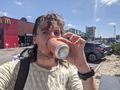
Bevvy from Dan's
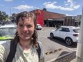
Made it


Achievements
John and Steve earned the Bicycle geohash achievement
|