Difference between revisions of "2023-02-20 -37 145"
From Geohashing
([live picture]Traffic Hash success [https://openstreetmap.org/?mlat=-37.81697778&mlon=145.11541111&zoom=16 @-37.8170,145.1154]) |
|||
| Line 13: | Line 13: | ||
}}<!-- edit as necessary --> | }}<!-- edit as necessary --> | ||
== Location == | == Location == | ||
| − | + | Between two lanes of traffic on Whitehorse Rd, Box Hill. | |
| + | == Participants == | ||
| + | Expedition 1: | ||
| + | |||
| + | * [[User:Lachie|Lachie]] | ||
| + | * [[User:Johnrw|Johnrw]] | ||
| + | |||
| + | Expedition 2: | ||
| − | + | * [[User:Stevage|Stevage]] | |
| − | |||
| − | |||
== Plans == | == Plans == | ||
<!-- what were the original plans --> | <!-- what were the original plans --> | ||
| − | == Expedition == | + | == Expedition 2: Stevage == |
| − | + | ||
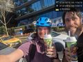
| + | [[File:PXL_20230220_075845625.jpg|400px]] | ||
| + | |||
| + | After going to an enormous amount of effort the other day to claim the Warrnambool virgin graticule, it seemed fitting to balance it out with a zero-effort hash. | ||
| + | |||
| + | I got in the car. | ||
| + | |||
| + | I drove to Box Hill. | ||
| + | |||
| + | I drove down Whitehorse Road, on the right hand side of the left lane, with my phone by the driver's side window. | ||
| + | |||
| + | I pulled over, checked that Hashdroid had indeed registered a success, took a belated selfie, and drove home. | ||
== Tracklog == | == Tracklog == | ||
| Line 55: | Line 71: | ||
<!-- If all those plans are never acted upon, change [[Category:Expedition planning]] to [[Category:Not reached - Did not attempt]]. --> | <!-- If all those plans are never acted upon, change [[Category:Expedition planning]] to [[Category:Not reached - Did not attempt]]. --> | ||
| − | |||
[[Category:Expeditions]] | [[Category:Expeditions]] | ||
| − | |||
[[Category:Expeditions with photos]] | [[Category:Expeditions with photos]] | ||
| − | |||
| − | |||
| − | |||
| − | |||
| − | |||
[[Category:Coordinates reached]] | [[Category:Coordinates reached]] | ||
| − | |||
| − | |||
| − | |||
| − | |||
| − | |||
| − | |||
| − | |||
| − | |||
| − | |||
| − | |||
| − | |||
| − | |||
| − | |||
| − | |||
| − | |||
| − | |||
| − | |||
| − | |||
Revision as of 04:18, 21 February 2023
| Mon 20 Feb 2023 in -37,145: -37.8170114, 145.1154055 geohashing.info google osm bing/os kml crox |
Location
Between two lanes of traffic on Whitehorse Rd, Box Hill.
Participants
Expedition 1:
Expedition 2:
Plans
Expedition 2: Stevage

After going to an enormous amount of effort the other day to claim the Warrnambool virgin graticule, it seemed fitting to balance it out with a zero-effort hash.
I got in the car.
I drove to Box Hill.
I drove down Whitehorse Road, on the right hand side of the left lane, with my phone by the driver's side window.
I pulled over, checked that Hashdroid had indeed registered a success, took a belated selfie, and drove home.
Tracklog
Photos
Traffic Hash success @-37.8170,145.1154
