Difference between revisions of "2023-03-08 51 13"
(Created page with "{{subst:Expedition}}") |
(→Plans) |
||
| (5 intermediate revisions by 2 users not shown) | |||
| Line 1: | Line 1: | ||
| − | + | {{meetup graticule | |
| − | |||
| − | |||
| − | |||
| − | |||
| − | |||
| − | |||
| − | |||
| − | |||
| lat={{#explode:{{SUBPAGENAME}}| |1}} | | lat={{#explode:{{SUBPAGENAME}}| |1}} | ||
| lon={{#explode:{{SUBPAGENAME}}| |2}} | | lon={{#explode:{{SUBPAGENAME}}| |2}} | ||
| date={{#explode:{{SUBPAGENAME}}| |0}} | | date={{#explode:{{SUBPAGENAME}}| |0}} | ||
}}<!-- edit as necessary --> | }}<!-- edit as necessary --> | ||
| + | |||
== Location == | == Location == | ||
| − | + | The hash is located on the sidewalk of a residential street in the Pieschen area of Dresden. The place should be accessible. | |
== Participants == | == Participants == | ||
| − | + | [[User:Oisín|Oisín]] | |
| − | |||
== Plans == | == Plans == | ||
| − | + | [[User:Oisín|Oisín]] tries to cycle to the hash in the late afternoon after work. For him this would be a [[Déjà vu geohash achievement]] as he lives nearby and has cycled and walk this street many times. The hash is located close to the [[2015-01-15 51 13]] hash point, that could not be reached. | |
== Expedition == | == Expedition == | ||
| − | + | ||
| + | === Oisín === | ||
| + | The weather was not too good, it was raining lightly at 3°C, but I decided nevertheless to visit the hash point. As I know the area well I decided to visit the hash without looking at my phone in order to receive the [[No Batteries Geohash]] achievement. When I arrived I parked my bike on the sidewalk and went close to the kerbstone where the hash was located according to satellite images. I took a few quick pictures and rode home the last mile. Since I track my activities on Strava I have a screenshot of my visit that I took afterwards at home. | ||
== Tracklog == | == Tracklog == | ||
| − | < | + | <gallery perrow="5"> |
| + | File:2023-03-08 51 13 Screenshot.jpg | Screenshot of my recorded track at the hash location | ||
| + | </gallery> | ||
== Photos == | == Photos == | ||
| − | |||
| − | |||
| − | |||
<gallery perrow="5"> | <gallery perrow="5"> | ||
| + | File:2023-03-08 51 13 O1.jpg | the hash is located just in front of the crubs | ||
| + | File:2023-03-08 51 13 O2.jpg | Oisín at the hash | ||
</gallery> | </gallery> | ||
| Line 38: | Line 33: | ||
{{#vardefine:ribbonwidth|100%}} | {{#vardefine:ribbonwidth|100%}} | ||
<!-- Add any achievement ribbons you earned below, or remove this section --> | <!-- Add any achievement ribbons you earned below, or remove this section --> | ||
| + | |||
| + | {{Déjà vu geohash | ||
| + | | latitude = 51 | ||
| + | | longitude = 13 | ||
| + | | date = 2023-03-08 | ||
| + | | olddate = many occasions in the last decades | ||
| + | | name = Oisín | ||
| + | }} | ||
| + | {{No_batteries_geohash | ||
| + | | latitude = 51 | ||
| + | | longitude = 13 | ||
| + | | date = 2023-03-08 | ||
| + | | name = Oisín | ||
| + | }} | ||
__NOTOC__ | __NOTOC__ | ||
| − | |||
| − | |||
| − | |||
| − | |||
| − | |||
| − | |||
| − | |||
| − | |||
| − | |||
| − | |||
| − | |||
| − | |||
| − | |||
| − | |||
[[Category:Expeditions]] | [[Category:Expeditions]] | ||
| − | |||
[[Category:Expeditions with photos]] | [[Category:Expeditions with photos]] | ||
| − | |||
[[Category:Expedition without GPS]] | [[Category:Expedition without GPS]] | ||
| − | |||
| − | |||
| − | |||
[[Category:Coordinates reached]] | [[Category:Coordinates reached]] | ||
| − | + | {{location|DE|SN|DD}} | |
| − | |||
| − | |||
| − | |||
| − | |||
| − | |||
| − | |||
| − | |||
| − | |||
| − | |||
| − | |||
| − | |||
| − | |||
| − | |||
| − | |||
| − | |||
| − | |||
| − | |||
Latest revision as of 08:52, 9 March 2023
| Wed 8 Mar 2023 in 51,13: 51.0901904, 13.7238387 geohashing.info google osm bing/os kml crox |
Location
The hash is located on the sidewalk of a residential street in the Pieschen area of Dresden. The place should be accessible.
Participants
Plans
Oisín tries to cycle to the hash in the late afternoon after work. For him this would be a Déjà vu geohash achievement as he lives nearby and has cycled and walk this street many times. The hash is located close to the 2015-01-15 51 13 hash point, that could not be reached.
Expedition
Oisín
The weather was not too good, it was raining lightly at 3°C, but I decided nevertheless to visit the hash point. As I know the area well I decided to visit the hash without looking at my phone in order to receive the No Batteries Geohash achievement. When I arrived I parked my bike on the sidewalk and went close to the kerbstone where the hash was located according to satellite images. I took a few quick pictures and rode home the last mile. Since I track my activities on Strava I have a screenshot of my visit that I took afterwards at home.
Tracklog

Screenshot of my recorded track at the hash location

Photos
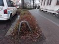
the hash is located just in front of the crubs
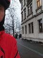
Oisín at the hash


Achievements
Oisín earned the Déjà Vu Geohash Achievement
|
Oisín earned the No Batteries Geohash Achievement
|