Difference between revisions of "2023-03-31 47 -122"
Heatherbee (talk | contribs) (→Location) |
Heatherbee (talk | contribs) (→Expedition) |
||
| (11 intermediate revisions by 3 users not shown) | |||
| Line 8: | Line 8: | ||
And DON'T FORGET to add your expedition and the best photo you took to the gallery on the Main Page! We'd love to read your report, but that means we first have to discover it! :) | And DON'T FORGET to add your expedition and the best photo you took to the gallery on the Main Page! We'd love to read your report, but that means we first have to discover it! :) | ||
-->{{meetup graticule | -->{{meetup graticule | ||
| − | | lat=47 | + | | lat=47 |
| − | | lon=-122 | + | | lon=-122 |
| date=2023-03-31 | | date=2023-03-31 | ||
}}<!-- edit as necessary --> | }}<!-- edit as necessary --> | ||
== Location == | == Location == | ||
| − | + | Tahuya State Forest, a few meters off of NE Sand Hill Rd, near the Sandhill trailhead outside Belfair, WA | |
== Participants == | == Participants == | ||
| − | Heatherbee | + | *[[User:Heatherbee|Heatherbee]] |
== Plans == | == Plans == | ||
| − | + | Find the hashpoint and take a walk on nearby trails | |
== Expedition == | == Expedition == | ||
| − | + | This morning I downloaded the Geohashing app and, with beginner's luck, found that the hashpoint in my graticule was near the side of the road in a state forest in an area with abundant trails I hadn't hiked yet. The complication was that I had an 11:15 job interview over Zoom, and the hashpoint was just over an hour away, not leaving me enough time to hike and get home. I located a local library branch where I could do the interview, mapped out the drive times, and decided the timeline would work. I put my laptop, a dress shirt, and a blazer in the car and hit the road. | |
| − | + | As I drew even with the hashpoint, I saw an officer parked up ahead in front of a gate. I wasn't sure if I could park at the side of the road; there was no shoulder to speak of. I pulled up beside the officer and asked her if I could park there. She directed me to a trailhead just a little ways down the road. | |
| − | + | ||
| + | I parked at the trailhead and called the library, which had just opened, to reserve a meeting room for my job interview. I estimated I had 30 minutes for a mini hike, so I rambled for a bit. Then I used AllTrails to find my way back in the direction of the hashpoint. I found it in a mossy area of new-growth forest with a lot of salal and some huckleberry bushes. Then I took the road back to the parking lot and headed back to the library in Belfair for my job interview video call. | ||
== Photos == | == Photos == | ||
| Line 32: | Line 33: | ||
--> | --> | ||
<gallery perrow="5"> | <gallery perrow="5"> | ||
| + | File:PXL_20230331_174156889.jpg|Me at the hashpoint | ||
| + | File:PXL_20230331_174209148.jpg|The hashpoint | ||
</gallery> | </gallery> | ||
| Line 37: | Line 40: | ||
{{#vardefine:ribbonwidth|100%}} | {{#vardefine:ribbonwidth|100%}} | ||
<!-- Add any achievement ribbons you earned below, or remove this section --> | <!-- Add any achievement ribbons you earned below, or remove this section --> | ||
| + | {{land geohash | ||
| + | | latitude = 47 | ||
| + | | longitude = -122 | ||
| + | | date = 2023-03-31 | ||
| + | }} | ||
__NOTOC__ | __NOTOC__ | ||
| − | |||
| − | |||
| − | |||
| − | |||
| − | |||
| − | |||
| − | |||
| − | |||
| − | |||
| − | |||
| − | |||
| − | |||
| − | |||
| − | |||
[[Category:Expeditions]] | [[Category:Expeditions]] | ||
| − | |||
[[Category:Expeditions with photos]] | [[Category:Expeditions with photos]] | ||
| − | |||
| − | |||
| − | |||
| − | |||
| − | |||
[[Category:Coordinates reached]] | [[Category:Coordinates reached]] | ||
| − | + | {{location|US|WA|MA}} | |
| − | |||
| − | |||
| − | |||
| − | |||
| − | |||
| − | |||
| − | |||
| − | |||
| − | |||
| − | |||
| − | |||
| − | |||
| − | |||
| − | |||
| − | |||
| − | |||
| − | |||
Latest revision as of 01:01, 2 April 2023
| Fri 31 Mar 2023 in 47,-122: 47.4734851, -122.8711676 geohashing.info google osm bing/os kml crox |
Location
Tahuya State Forest, a few meters off of NE Sand Hill Rd, near the Sandhill trailhead outside Belfair, WA
Participants
Plans
Find the hashpoint and take a walk on nearby trails
Expedition
This morning I downloaded the Geohashing app and, with beginner's luck, found that the hashpoint in my graticule was near the side of the road in a state forest in an area with abundant trails I hadn't hiked yet. The complication was that I had an 11:15 job interview over Zoom, and the hashpoint was just over an hour away, not leaving me enough time to hike and get home. I located a local library branch where I could do the interview, mapped out the drive times, and decided the timeline would work. I put my laptop, a dress shirt, and a blazer in the car and hit the road.
As I drew even with the hashpoint, I saw an officer parked up ahead in front of a gate. I wasn't sure if I could park at the side of the road; there was no shoulder to speak of. I pulled up beside the officer and asked her if I could park there. She directed me to a trailhead just a little ways down the road.
I parked at the trailhead and called the library, which had just opened, to reserve a meeting room for my job interview. I estimated I had 30 minutes for a mini hike, so I rambled for a bit. Then I used AllTrails to find my way back in the direction of the hashpoint. I found it in a mossy area of new-growth forest with a lot of salal and some huckleberry bushes. Then I took the road back to the parking lot and headed back to the library in Belfair for my job interview video call.
Photos
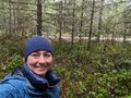
Me at the hashpoint
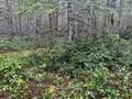
The hashpoint


Achievements
This user earned the Land geohash achievement
|