Difference between revisions of "2023-04-04 49 8"
Gefrierbrand (talk | contribs) (→Location) |
Gefrierbrand (talk | contribs) |
||
| Line 1: | Line 1: | ||
| − | + | {{meetup graticule | |
| − | |||
| − | |||
| − | |||
| − | |||
| − | |||
| − | |||
| − | |||
| − | |||
| lat=49 | | lat=49 | ||
| lon=8 | | lon=8 | ||
| Line 16: | Line 8: | ||
== Participants == | == Participants == | ||
| − | + | * [[User:Santu|Santu]] | |
| − | + | * [[User:Gefrierbrand|Gefrierbrand]] | |
| + | * Pedro the dog | ||
| − | |||
| − | |||
== Expedition == | == Expedition == | ||
| − | + | We were on or way back home and decided to take a small detour to go on a hashing adventure. We coudn't take the direct route since the path was blocked by an electric fence. So we tried walking around it on another path, which was a good thing: | |
| + | |||
| + | This hash was very close to a [[2021-08-27 49 8|previous one]] we did in 2021, but had almost forgotten. As soon as we came across a nice hut in the forest however, we remembered our earlier adventure there and recreated some of the pictures by climbing on a fallen tree. We would not have stumbled across this if the direct route had been available. | ||
| + | |||
| + | Shortly after, we found another way leading potentially towards the hash and we managed to get very close before being stopped by thorn bushes and a grid fence, but fortunately Pedro was not afraid to enter the shrubbery and we inched ourselves across it to get within GPS accuracy. | ||
| + | |||
| + | Right next to the field with the hash on it was a vineyard where some sheep were grazing and curiously approached us. Pedro was very eager to visit them and have a quick play, but we (and the fence) had to deny him that pleasure. We then headed back and had a very nice dinner in Seeheim before returning home. | ||
| + | |||
== Tracklog == | == Tracklog == | ||
| Line 29: | Line 27: | ||
== Photos == | == Photos == | ||
| − | + | ||
| − | |||
| − | |||
<gallery perrow="5"> | <gallery perrow="5"> | ||
| − | + | Image:2023-04-04_49_8_Gefrierbrand_1680698932604.jpg|nice tree stump | |
| − | Image:2023-04-04_49_8_Gefrierbrand_1680698702825.jpg|climbing | + | Image:2023-04-04_49_8_Gefrierbrand_1680698870938.jpg|Nice hut in the forest |
| − | + | Image:2023-04-04_49_8_Gefrierbrand_1680698702825.jpg|Gefrierbrand climbing | |
| + | Image:2023-04-04_49_8_Gefrierbrand_1680698889395.jpg|Santu recreating her earlier [[2021-08-27 49 8#Photos | monkey business]] | ||
| + | Image:2023-04-04_49_8_Gefrierbrand_1680698976402.jpg|Pedo on the rocks | ||
| + | Image:2023-04-04_49_8_Gefrierbrand_1680698846618.jpg|Gate almost stopping us ... | ||
| + | Image:2023-04-04_49_8_Gefrierbrand_1680699010539.jpg|... and thorny shrubbery and fence also almost stopping us | ||
| + | Image:2023-04-04_49_8_Gefrierbrand_1680698823844.jpg|StupidGrin<sup>TM</sup> | ||
| + | Image:2023-04-04_49_8_Gefrierbrand_1680698787298.jpg|watching sheep | ||
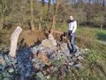
Image:2023-04-04_49_8_Gefrierbrand_1680698741836.jpg|Proof | Image:2023-04-04_49_8_Gefrierbrand_1680698741836.jpg|Proof | ||
| − | |||
| − | |||
| − | |||
| − | |||
| − | |||
| − | |||
| − | |||
| − | |||
| − | |||
| − | |||
| − | |||
| − | |||
| − | |||
| − | |||
| − | |||
</gallery> | </gallery> | ||
== Achievements == | == Achievements == | ||
{{#vardefine:ribbonwidth|100%}} | {{#vardefine:ribbonwidth|100%}} | ||
| − | + | {{land geohash | |
| + | |||
| + | | latitude = 49 | ||
| + | | longitude = 8 | ||
| + | | date = 2023-04-04 | ||
| + | | name = Gefrierbrand & Santu | ||
| + | }} | ||
__NOTOC__ | __NOTOC__ | ||
| − | |||
| − | |||
| − | |||
| − | |||
| − | |||
| − | |||
| − | |||
| − | |||
| − | |||
| − | |||
| − | |||
| − | |||
| − | |||
| − | |||
[[Category:Expeditions]] | [[Category:Expeditions]] | ||
| − | |||
[[Category:Expeditions with photos]] | [[Category:Expeditions with photos]] | ||
| − | |||
| − | |||
| − | |||
| − | |||
| − | |||
[[Category:Coordinates reached]] | [[Category:Coordinates reached]] | ||
| − | |||
| − | |||
| − | |||
| − | |||
| − | |||
| − | |||
| − | |||
| − | |||
| − | |||
| − | |||
| − | |||
| − | |||
| − | |||
| − | |||
| − | |||
| − | |||
| − | |||
| − | |||
Revision as of 13:25, 5 April 2023
| Tue 4 Apr 2023 in 49,8: 49.7706110, 8.6552800 geohashing.info google osm bing/os kml crox |
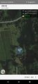
Location
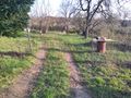
On the edge of a vineyard near Seeheim
Participants
- Santu
- Gefrierbrand
- Pedro the dog
Expedition
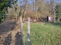
We were on or way back home and decided to take a small detour to go on a hashing adventure. We coudn't take the direct route since the path was blocked by an electric fence. So we tried walking around it on another path, which was a good thing:
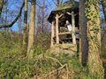
This hash was very close to a previous one we did in 2021, but had almost forgotten. As soon as we came across a nice hut in the forest however, we remembered our earlier adventure there and recreated some of the pictures by climbing on a fallen tree. We would not have stumbled across this if the direct route had been available.
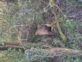
Shortly after, we found another way leading potentially towards the hash and we managed to get very close before being stopped by thorn bushes and a grid fence, but fortunately Pedro was not afraid to enter the shrubbery and we inched ourselves across it to get within GPS accuracy.
Right next to the field with the hash on it was a vineyard where some sheep were grazing and curiously approached us. Pedro was very eager to visit them and have a quick play, but we (and the fence) had to deny him that pleasure. We then headed back and had a very nice dinner in Seeheim before returning home.
Tracklog
Photos
nice tree stump
Nice hut in the forest
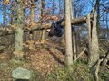
Gefrierbrand climbing
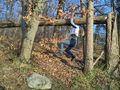
Santu recreating her earlier monkey business
Pedo on the rocks
Gate almost stopping us ...
... and thorny shrubbery and fence also almost stopping us

StupidGrinTM
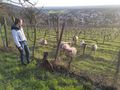
watching sheep
Proof


Achievements
Gefrierbrand & Santu earned the Land geohash achievement
|