Difference between revisions of "2023-04-07 41 -71"
From Geohashing
(→Photos) |
(→Photos) |
||
| Line 39: | Line 39: | ||
Image:2023_04_07_41_-71_Cabrio&Museum4.jpeg | My mistress and I parked near the hashpoint near Roger Williams Park Natural History Museum | Image:2023_04_07_41_-71_Cabrio&Museum4.jpeg | My mistress and I parked near the hashpoint near Roger Williams Park Natural History Museum | ||
Image:2023_04_07_41_-71_latlong1.jpeg | screenshot of our closest approach - about 115' too far north, and 36' too far east - I blame my driving glasses vs. reading glasses for not doing better. That, and almost being late for hot lunch date.... | Image:2023_04_07_41_-71_latlong1.jpeg | screenshot of our closest approach - about 115' too far north, and 36' too far east - I blame my driving glasses vs. reading glasses for not doing better. That, and almost being late for hot lunch date.... | ||
| − | Image:2023_04_07_41_-71_Vbob&Cabrio.jpeg | Silly | + | Image:2023_04_07_41_-71_Vbob&Cabrio.jpeg | Silly Grint™ |
| + | Image:2023_04_07_41_-71_poster_not_left.jpeg | decided NOT to leave the poster, as the grounds were immaculate! | ||
</gallery> | </gallery> | ||
Revision as of 18:46, 7 April 2023
| Fri 7 Apr 2023 in 41,-71: 41.7864111, -71.4120822 geohashing.info google osm bing/os kml crox |
Location
Just a few feet north of Natural History Avenue, the loop drive through Roger Williams Park, Providence, RI - should be very easy to get to.
Participants
Plans
Should be a fine day, and a Good Friday holiday, so the chance to get out and remember how to hash-dance seems ideal! Probably going to try to visit early afternoon, if there are any other Silly Grinners in these parts.
Expedition
Tracklog
Photos
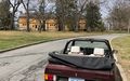
My mistress and I parked near the hashpoint near Roger Williams Park Natural History Museum
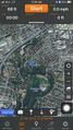
screenshot of our closest approach - about 115' too far north, and 36' too far east - I blame my driving glasses vs. reading glasses for not doing better. That, and almost being late for hot lunch date....
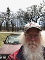
Silly Grint™
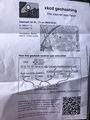
decided NOT to leave the poster, as the grounds were immaculate!


Achievements