Difference between revisions of "2023-04-11 48 7"
(→Location) |
(Coordinates reached) |
||
| Line 12: | Line 12: | ||
== Plans == | == Plans == | ||
[[User:Baarde|Baarde]] will cycle there after work. | [[User:Baarde|Baarde]] will cycle there after work. | ||
| + | |||
| + | == Expedition == | ||
| + | I left home after work and cycled from Sélestat to Elsenheim. The geohash was located in a wheat field near the village. A couple were walking their dogs near the field, then a farmer came and planted a couple of stake in an adjacent field. As I didn't want to attract too much attention, I waited for everybody to go away, standing next to my bicycle, casually looking at my phone, for 10 minutes, with my high-vis cycling jacket. | ||
| + | |||
| + | Once I was relatively alone, I left the path and walked the remaining 200 meters. There were large unsown tractor tracks that crossed the field from side to side. As I approached the hashpoint, the wheat plants became smaller and sparser, and I managed to reach the coordinates without damaging the crops. | ||
| + | |||
| + | After recording proof, I cycled back home. | ||
| + | |||
| + | == Photos == | ||
| + | <gallery> | ||
| + | File:2023-04-11 48 7 01.jpeg | In Elsenheim | ||
| + | File:2023-04-11 48 7 02.jpeg | Near the coordinates | ||
| + | File:2023-04-11 48 7 03.jpeg | Walking through the field | ||
| + | File:2023-04-11 48 7 04.png | Coordinates reached | ||
| + | File:2023-04-11 48 7 05.jpeg | Surroundings (South-East) | ||
| + | File:2023-04-11 48 7 06.jpeg | Surroundings (North-West) | ||
| + | File:2023-04-11 48 7 07.jpeg | Stupid grin | ||
| + | </gallery> | ||
| + | |||
| + | == Achievements == | ||
| + | {{#vardefine:ribbonwidth|100%}} | ||
| + | {{land geohash | ||
| + | | latitude = 48 | ||
| + | | longitude = 7 | ||
| + | | date = 2023-04-11 | ||
| + | | name = [[User:Baarde|Baarde]] | ||
| + | }} | ||
| + | {{bicycle geohash | ||
| + | | latitude = 48 | ||
| + | | longitude = 7 | ||
| + | | date = 2023-04-11 | ||
| + | | name = [[User:Baarde|Baarde]] | ||
| + | | distance = 37 km | ||
| + | | bothways = true | ||
| + | }} | ||
__NOTOC__ | __NOTOC__ | ||
| − | [[Category: | + | [[Category:Expeditions]] |
| + | [[Category:Coordinates reached]] | ||
| + | [[Category:Expeditions with photos]] | ||
{{location|FR|67}} | {{location|FR|67}} | ||
Latest revision as of 21:04, 11 April 2023
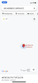
| Tue 11 Apr 2023 in 48,7: 48.1680829, 7.4905472 geohashing.info google osm bing/os kml crox |
Location
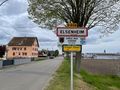
In a wheat field in Elsenheim.
Participants
Plans
Baarde will cycle there after work.
Expedition
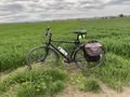
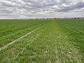
I left home after work and cycled from Sélestat to Elsenheim. The geohash was located in a wheat field near the village. A couple were walking their dogs near the field, then a farmer came and planted a couple of stake in an adjacent field. As I didn't want to attract too much attention, I waited for everybody to go away, standing next to my bicycle, casually looking at my phone, for 10 minutes, with my high-vis cycling jacket.
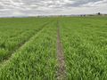
Once I was relatively alone, I left the path and walked the remaining 200 meters. There were large unsown tractor tracks that crossed the field from side to side. As I approached the hashpoint, the wheat plants became smaller and sparser, and I managed to reach the coordinates without damaging the crops.
After recording proof, I cycled back home.
Photos
In Elsenheim
Near the coordinates
Walking through the field
Coordinates reached
Surroundings (South-East)
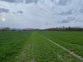
Surroundings (North-West)
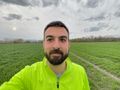
Stupid grin


Achievements
Baarde earned the Land geohash achievement
|
Baarde earned the Bicycle geohash achievement
|