Difference between revisions of "2023-04-12 48 7"
| Line 12: | Line 12: | ||
== Plans == | == Plans == | ||
[[User:Baarde|Baarde]] will cycle there after work. | [[User:Baarde|Baarde]] will cycle there after work. | ||
| + | |||
| + | == Plans == | ||
| + | I left home in the evening and cycled to the Haut-Koenigsbourg. The route was fairly short but quite steep and rainy. I arrived one hour later at the coordinates, which were located near some kind of precast concrete utility building. | ||
| + | |||
| + | After recording proof, I completed the remaining kilometer up to castle. There, I wrote and posted a hashcard (which I had bought in advance) to [[User:Kripakko|Kripakko]] while waiting for the clouds to go away. After 20 minutes, I got a nice view on the plain below. Then I went home, which was faster and much easier that the way there. | ||
| + | |||
| + | == Photos == | ||
| + | <gallery> | ||
| + | File:2023-04-12 48 7 01.jpg | The Haut-Koenisbourg in the distance | ||
| + | File:2023-04-12 48 7 02.jpg | My bicycle near the coordinates | ||
| + | File:2023-04-12 48 7 03.png | Coordinates reached | ||
| + | File:2023-04-12 48 7 04.jpg | Surroundings (South-West) | ||
| + | File:2023-04-12 48 7 05.jpg | Surroundings (North-East) | ||
| + | File:2023-04-12 48 7 06.jpg | Stupid grin | ||
| + | File:2023-04-12 48 7 07.jpg | The Haut-Koenisbourg up close | ||
| + | File:2023-04-12 48 7 08.jpg | Writing a hashcard | ||
| + | File:2023-04-12 48 7 09.jpg | The plain below | ||
| + | File:2023-04-12 48 7 10.jpg | In Orschwiller | ||
| + | </gallery> | ||
== Achievements == | == Achievements == | ||
| Line 47: | Line 66: | ||
__NOTOC__ | __NOTOC__ | ||
[[Category:Expeditions]] | [[Category:Expeditions]] | ||
| + | [[Category:Expeditions with photos]] | ||
| + | [[Category:Coordinates reached]] | ||
{{location|FR|67}} | {{location|FR|67}} | ||
Latest revision as of 18:12, 20 April 2023
| Wed 12 Apr 2023 in 48,7: 48.2470165, 7.3362533 geohashing.info google osm bing/os kml crox |
Location
In the woods around the Château du Haut-Koenigsbourg, in Orschwiller.
Participants
Plans
Baarde will cycle there after work.
Plans
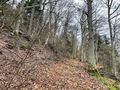
I left home in the evening and cycled to the Haut-Koenigsbourg. The route was fairly short but quite steep and rainy. I arrived one hour later at the coordinates, which were located near some kind of precast concrete utility building.
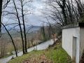
After recording proof, I completed the remaining kilometer up to castle. There, I wrote and posted a hashcard (which I had bought in advance) to Kripakko while waiting for the clouds to go away. After 20 minutes, I got a nice view on the plain below. Then I went home, which was faster and much easier that the way there.
Photos
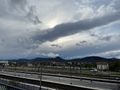
The Haut-Koenisbourg in the distance
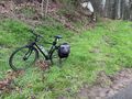
My bicycle near the coordinates
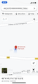
Coordinates reached
Surroundings (South-West)
Surroundings (North-East)
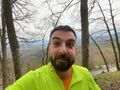
Stupid grin
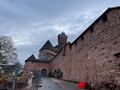
The Haut-Koenisbourg up close
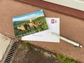
Writing a hashcard
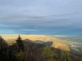
The plain below
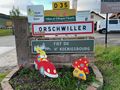
In Orschwiller


Achievements
Baarde earned the Land geohash achievement
|
Baarde earned the Bicycle geohash achievement
|
Baarde earned the Consecutive geohash achievement
|
Baarde earned the Hashcard achievement
|